
Highlights
- The updated consolidated Mineral Resource Estimate (“MRE”) reaffirms the Shaakichiuwaanaan Lithium Project as a Tier-1, world-class asset and positions it as the largest lithium pegmatite Indicated Mineral Resource in the Americas:
- Consolidated MRE statement (CV5 & CV13 spodumene pegmatites):
- Indicated: 108.0 Mt at 1.40% Li2O, 166 ppm Ta2O5, and 66 ppm Ga, and
- Inferred: 33.3 Mt at 1.33% Li2O, 156 ppm Ta2O5, and 65 ppm Ga.
- The MRE update represents an increase of ~30% and ~306% in Indicated Resources at the CV5 and CV13 pegmatites compared to the August 2024 MRE, respectively, with overall contained lithium carbonate equivalent (“LCE”) of 3.75 Mt Indicated and 1.09 Mt Inferred.
- Importantly, the high-grade Nova Zone (CV5) has now been fully delineated to an Indicated classification, as well as a significant portion of the high-grade Vega Zone (CV13) where size and lithium grade notably increased.
- The Company remains on track to deliver a maiden Ore Reserve and Feasibility Study for its CV5 Spodumene Pegmatite in CYQ3-2025 based on this updated MRE.
- The MRE includes 9 km of collective strike length confirmed to host continuous spodumene pegmatite Mineral Resources (4.6 km at CV5 and 2.3 km at CV13).
- Significant resource growth potential – both the CV5 and CV13 spodumene pegmatites remain open in multiple directions, as well as other spodumene pegmatite clusters at the Property that remain to be drill tested.
- Other high-grade/value critical/strategic metals such as tantalum, cesium and now gallium have been identified at the Property with potential to become meaningful future by-products.
- Cesium within the CV13 Pegmatite is anticipated to be included in a future MRE update for the Project.
- The MRE includes only the CV5 and CV13 spodumene pegmatites. It does not include any of the other known spodumene pegmatite clusters on the Property – CV4, CV8, CV9, CV10, CV12, CV14, and the recently discovered CV15 (fall 2024).
Darren L. Smith, Executive and Vice President of Exploration for the Company, comments: “The results of the updated MRE at CV5 have exceeded our expectations with over 100 Mt of Indicated Resources now defined, of which the vast majority resides within only a single pegmatite dyke and includes the high-grade Nova Zone. Additionally, at the CV13 Pegmatite while delineating the high-grade Vega Zone, a total of 6.1 Mt at 1.87% Li2O of Indicated Resources has now been defined, representing a 306% increase in Indicated tonnage and a 16% increase in Indicated grade compared to the August 2024 MRE.”
“Collectively, this updated MRE represents a significant increase in resource confidence and an important derisking event for the Project as it advances towards Feasibility on the path to production. Shaakichiuwaanaan continues to demonstrate its Tier-1, world-class nature and robustness as it further positions itself to be a key player in the lithium raw materials industry.”
Ken Brinsden, President, CEO, and Managing Director, comments: “This is another significant accomplishment for our team and a key milestone for the Company as we approach the completion of our Feasibility Study on the CV5 Pegmatite, which remains on schedule for CYQ3-2025. It further cements the position of the Shaakichiuwaanaan Project as one of the most important hard rock lithium assets in development globally.”
“The delivery of a substantial updated consolidated Indicated Resource of 108 Mt is a major milestone which will underpin our development studies. The continued derisking of the overall resource, while maintaining tonnage and grade, as well as the significant presence of other strategic and critical metals like tantalum, cesium, and now gallium, highlights the Tier-1 scale of the mineral system and the considerable potential for further growth and value creation for shareholders.”
“As we advance towards a Feasibility Study, the Company is firmly positioned to be able to provide long-term future spodumene supply and other critical metals to the North American and European markets. The combination of scale, management quality, balance sheet strength, and our high-quality strategic partnerships allows us to remain confident in the success of our strategy,” added Mr. Brinsden.
Patriot Battery Metals Inc. (the “Company” or “Patriot”) (TSX: PMET) (ASX: PMT) (OTCQX: PMETF) (FSE: R9GA) is pleased to announce an updated consolidated Mineral Resource Estimate (“MRE” or “Consolidated MRE”) for the CV5 and CV13 spodumene pegmatites at its 100%-owned Shaakichiuwaanaan Property (the “Property” or “Project”) located in the Eeyou Istchee James Bay region of Quebec. The CV5 Spodumene Pegmatite is situated approximately 13 km south of the regional and all‑weather Trans-Taiga Road and powerline infrastructure corridor, and is accessible year-round by all-season road. The CV13 Spodumene Pegmatite is located approximately 3 km west-southwest along geological trend of CV5.
The updated Consolidated MRE for the Project includes both the CV5 and CV13 spodumene pegmatites and totals 108.0 Mt at 1.40% Li2O Indicated and 33.3 Mt at 1.33% Li2O Inferred, for a contained lithium carbonate equivalent (“LCE”) of 3.75 Mt Indicated and 1.09 Mt Inferred (Table 1, Figure 1, and Figure 2). Presented by resource location/name, this MRE includes 101.8 Mt at 1.38% Li2O Indicated and 13.9 Mt at 1.21% Li2O Inferred at CV5, and 6.1 Mt at 1.87% Li2O Indicated and 19.4 Mt at 1.42% Li2O Inferred at CV13. The cut-off grade is variable depending on the mining method and pegmatite (see footnotes in Table 1 for details). Mineral Resources are not Mineral Reserves as they do not have demonstrated economic viability.
The Consolidated MRE for the Shaakichiuwaanaan Project, the third MRE for the Project, continues to reaffirm it as the largest lithium pegmatite Mineral Resource in the Americas and 8th largest globally (Figure 1, Figure 2, Appendix 2 through 4). Additionally, the MRE now ranks as the largest lithium pegmatite Indicated Mineral Resource in the Americas (Figure 3). These metrics and context entrench the Project as a Tier 1, world-class lithium pegmatite asset.
Since the last MRE (August 2024), the focus of drilling at the CV5 Pegmatite has been on infill (targeting ~50 m spaced pegmatite pierce points) to support an upgrade in Mineral Resource confidence from the Inferred category to the Indicated category. The overarching objective of defining the additional Indicated Resources is to underpin the Company’s maiden Ore Reserve and Feasibility Study for the CV5 Pegmatite – on schedule for CYQ3-2025 – and which is anticipated to have a production scenario similar to that outlined in the 2024 Preliminary Economic Assessment (see news release dated August 21, 2024)
The Consolidated MRE statement for the Shaakichiuwaanaan Project, presented in Table 1, includes only the CV5 and CV13 spodumene pegmatites, which remain open in multiple directions. Therefore, this Consolidated MRE does not include any of the other known spodumene pegmatite clusters on the Property – CV4, CV8, CV9, CV10, CV12, CV14, and the recently discovered CV15 (Figure 4 and Figure 36). Collectively, this highlights considerable potential for resource growth in lithium, and other critical and strategic metals, which could support a larger or extended mining operation, through continued drill exploration at the Property.
The Mineral Resource statement and relevant disclosure, sensitivity analysis, peer comparison, geological and block model views, and cross-sections are presented in the following figures and tables. A detailed overview of the MRE and Project is presented in the following sections in accordance with ASX Listing Rule 5.8.
Mineral Resource Statement (NI 43-101)
Table 1: NI 43-101 Mineral Resource Statement for the Shaakichiuwaanaan Project.
| Pegmatite | Classification | Tonnes
(t) |
Li2O (%) |
Ta2O5 (ppm) |
Ga (ppm) |
Contained LCE (Mt) |
| CV5 & CV13 | Indicated | 107,955,000 | 1.40 | 166 | 66 | 3.75 |
| Inferred | 33,280,000 | 1.33 | 156 | 65 | 1.09 |
- Mineral Resources were prepared in accordance with National Instrument 43-101 – Standards for Disclosure of Mineral Projects (“NI 43-101”) and the CIM Definition Standards (2014). Mineral Resources that are not Mineral Reserves do not have demonstrated economic viability. This estimate of Mineral Resources may be materially affected by environmental, permitting, legal, title, taxation, sociopolitical, marketing, economic, or other relevant issues.
- The independent Competent Person (CP), as defined under JORC, and Qualified Person (QP), as defined by NI 43‑101 for this estimate is Todd McCracken, P.Geo., Director – Mining & Geology – Central Canada, BBA Engineering Ltd. The Effective Date of the estimate is January 6, 2025 (through drill hole CV24-787).
- Estimation was completed using a combination of inverse distance squared (ID2) and ordinary kriging (OK) for CV5 and inverse distance squared (ID2) for CV13 in Leapfrog Edge software with dynamic anisotropy search ellipse on specific domains.
- Drill hole composites at 1 m in length. Block size is 10 m x 5 m x 5 m with sub-blocking.
- Both underground and open-pit conceptual mining shapes were applied as constraints to demonstrate reasonable prospects for eventual economic extraction. Cut-off grades for open-pit constrained resources are 0.40% Li2O for both CV5 and CV13, and for underground constrained resources are 0.60% Li2O for CV5 and 0.70% Li2O for CV13. Open-pit and underground Mineral Resource constraints are based on a long-term average spodumene concentrate price of US$1,500/tonne (6% basis FOB Bécancour) and an exchange rate of 0.70 USD/CAD.
- Rounding may result in apparent summation differences between tonnes, grade, and contained metal content.
- Tonnage and grade measurements are in metric units.
- Conversion factors used: Li2O = Li x 2.153; LCE (i.e., Li2CO3) = Li2O x 2.473, Ta2O5 = Ta x 1.221.
- Densities for pegmatite blocks (both CV5 & CV13) were estimated using a linear regression function (SG = 0.0674x (Li2O% + 0.81 x B2O3%) + 2.6202) derived from the specific gravity (“SG”) field measurements and Li2O grade. Non-pegmatite blocks were assigned a fixed SG based on the field measurement median value of their respective lithology.
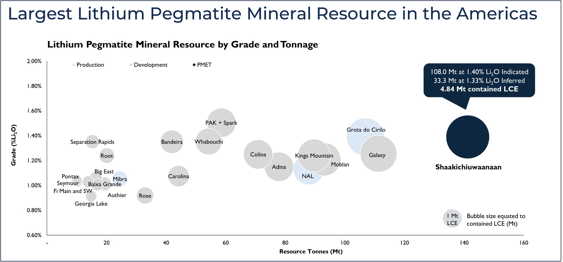
Figure 1: MRE tonnage vs grade chart highlighting Shaakichiuwaanaan as the largest lithium pegmatite Mineral Resource in the Americas. Mineral Resource data sourced through April 11, 2025, from corporate disclosure pursuant to NI 43-101, JORC, or equivalent regulatory body. Deposit/Project data presented includes the total resource tonnage. Mineral resources are presented on a 100% basis and inclusive of reserves where applicable. Data is presented for all pegmatite deposits/projects >10 Mt and >0.65% Li2O head grade. See Appendix 2 through 4 for further details and supporting information.
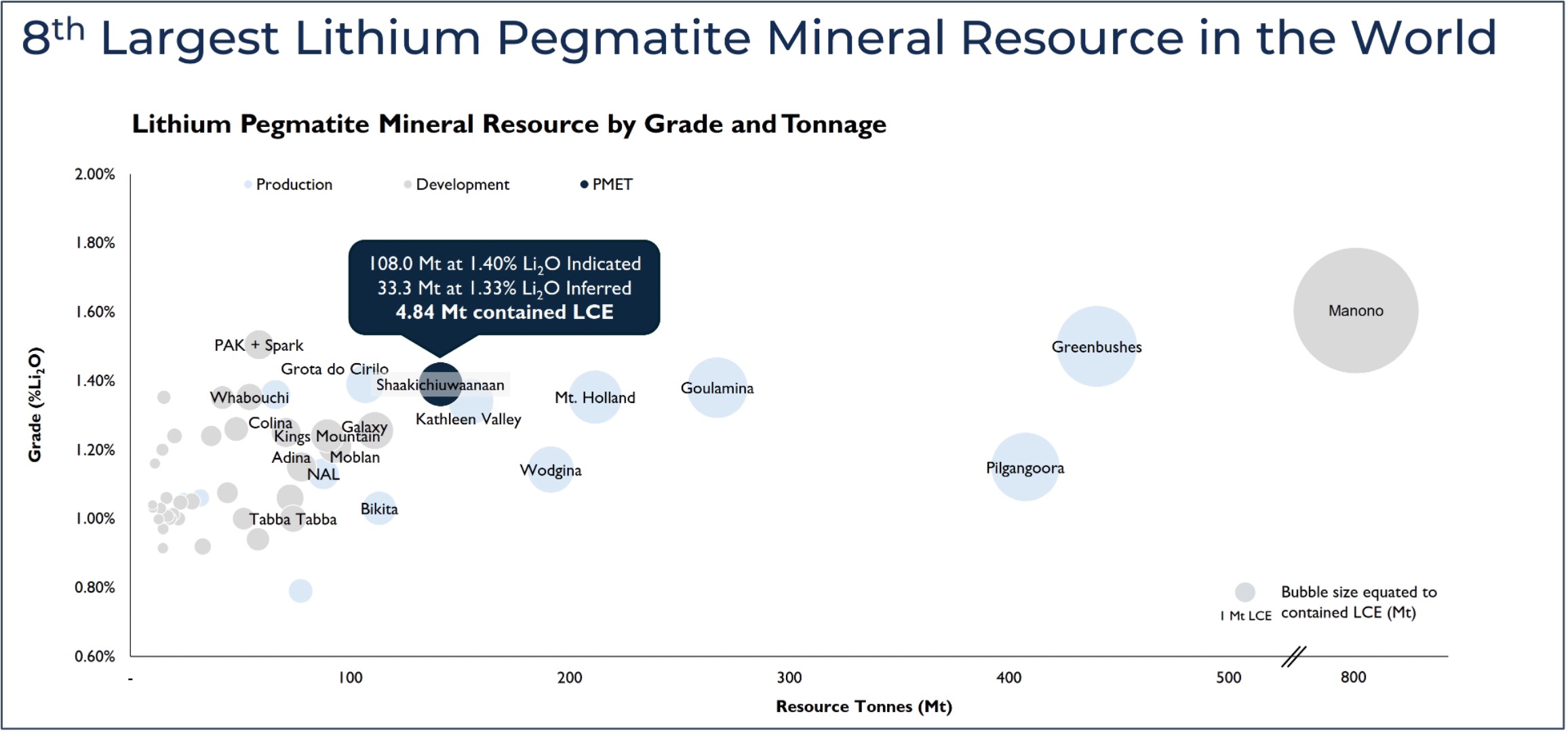
Figure 2: MRE tonnage vs grade chart highlighting Shaakichiuwaanaan as the 8th largest lithium pegmatite Mineral Resource in the world. See comments under Figure 1 and Appendix 2 through 4 for further details and supporting information.
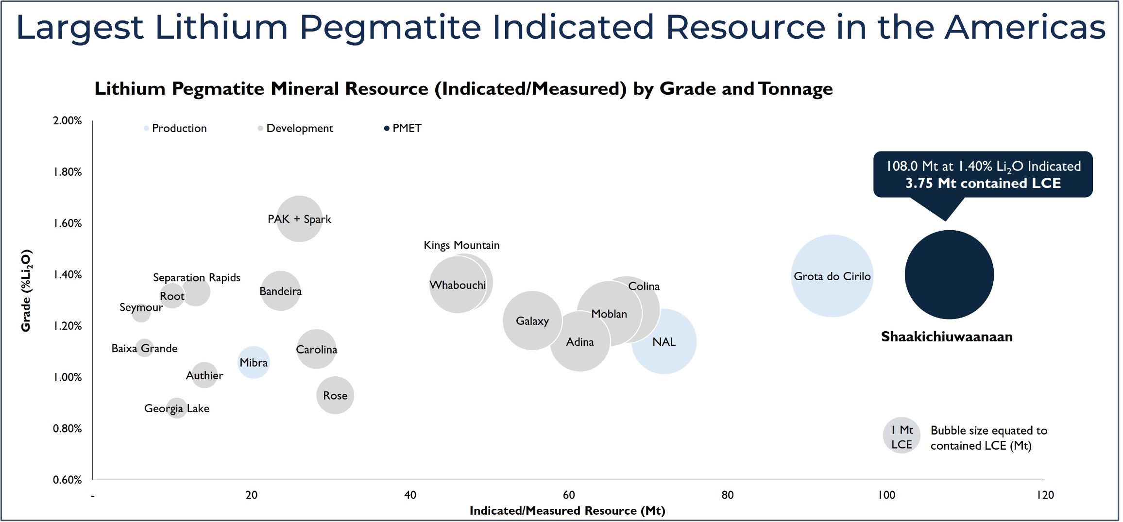
Figure 3: MRE tonnage vs grade chart highlighting Shaakichiuwaanaan as the largest lithium pegmatite Indicated Mineral Resource in the Americas. See comments under Figure 1 and Appendix 2 through 4 for further details and supporting information.
The Shaakichiuwaanaan MRE covers a collective strike length of approximately 6.9 km, drill hole to drill hole (4.6 km at CV5, and 2.3 km at CV13). The CV5 and CV13 pegmatites are situated along the same geological trend, separated by approximately 2.6 km of prospective trend (Figure 4). As such, given the similar mineralogy, geochemistry, host geological and structural trend, and close proximity to each other, the MREs for the CV5 and CV13 pegmatites have been presented as a consolidated MRE for the Project (Table 1). The MRE is further detailed below with respect to conceptual mining constraint shapes by resource location/name (Table 2).
Table 2: Shaakichiuwaanaan Mineral Resource by Pegmatite and Conceptual Mining Constraint.
| Cut-off Grade Li2O (%) |
Conceptual Mining Constraint | Pegmatite | Classification | Tonnes
(t) |
Li2O (%) |
Ta2O5 (ppm) |
Ga (ppm) |
Contained LCE (Mt) |
| 0.40 | Open-Pit | CV5 | Indicated | 97,757,000 | 1.39 | 163 | 66 | 3.35 |
| 0.60 | Underground | 4,071,000 | 1.08 | 186 | 66 | 0.11 | ||
| Total | 101,828,000 | 1.38 | 164 | 66 | 3.46 | |||
| 0.40 | Open-Pit | CV5 | Inferred | 5,745,000 | 1.16 | 163 | 61 | 0.17 |
| 0.60 | Underground | 8,153,000 | 1.24 | 136 | 60 | 0.25 | ||
| Total | 13,898,000 | 1.21 | 147 | 60 | 0.41 | |||
| 0.40 | Open-Pit | CV13 | Indicated | 5,960,000 | 1.90 | 200 | 76 | 0.28 |
| 0.70 | Underground | 167,000 | 0.86 | 131 | 60 | 0.00 | ||
| Total | 6,127,000 | 1.87 | 198 | 76 | 0.28 | |||
| 0.40 | Open-Pit | CV13 | Inferred | 17,920,000 | 1.45 | 169 | 70 | 0.64 |
| 0.70 | Underground | 1,462,000 | 1.05 | 75 | 55 | 0.04 | ||
| Total | 19,382,000 | 1.42 | 162 | 69 | 0.68 |
All Table 1 footnotes are applicable.
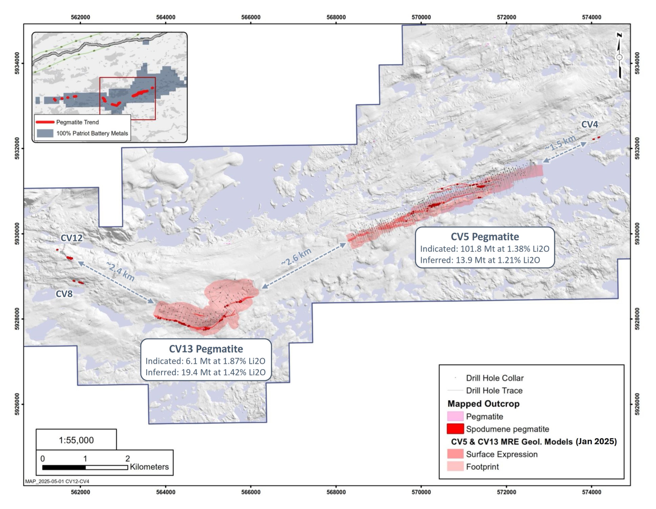
Figure 4: Extent of the Shaakichiuwaanaan MRE with respect to the spodumene pegmatite clusters in the area, highlighting potential for resource growth. CV5 and CV13 remain open in multiple directions.
Sensitivity Analysis
The sensitivity analysis for the Shaakichiuwaanaan MRE (Table 3 and Figure 5) is presented as the sum of the open-pit and underground constrained and classified resources at the same cut-off. The sensitivity analysis by cut-off grade (“COG”) defines significant tonnage at very high-grade, primarily reflecting the Nova Zone at CV5 and Vega Zone at CV13.
- At a 1.5% Li2O COG for the CV5 Pegmatite, there is a total of 35.8 Mt at 2.01 Li2O Indicated and 3.5 Mt at 1.98 Li2O Inferred.
- At a 1.5% Li2O COG for the CV13 Pegmatite, there is a total of 3.4 Mt at 2.62 Li2O Indicated and 6.7 Mt at 2.36 Li2O Inferred.
Both the Nova and Vega zones have been traced over a significant distance/area with multiple drill hole intercepts (core length) ranging from 2 to 25 m (CV5) and 2 to 10 m (CV13) at >5% Li2O, each within a significantly wider mineralized pegmatite zone of >2% Li2O (Figure 17, Figure 26, and Figure 27). These zones are located approximately 6 km apart, along the same geological trend, and emphasize not only the scale of the entire mineralized system at the Property but also its robustness in mineralized intensity defined to date.
The following Table 3 and Figure 5 outline the corresponding tonnage and lithium grade at various cut-off grades for the Shaakichiuwaanaan MRE. In addition to evaluating sensitivities to cut-off grades, this table can help relate the tonnage and grades at Shaakichiuwaanaan more directly to those calculated for peer deposits, which may have applied different cut-off grades to their resources.
Table 3: Sensitivity Analysis for the Shaakichiuwaanaan MRE.

- This table should not be interpreted as a Mineral Resource. The table presents the sum of the open-pit and underground constrained and classified resources at the same cut-off. The data is presented to demonstrate the Mineral Resource tonnage and grade sensitivity to various cut-off grades. The selected cut-off grade for the base case is 0.40% Li2O with the revenue factor 1 pit shell constraint for CV5 and CV13, with a 0.60% Li2O and 0.70% Li2O underground cut-off grade for CV5 and CV13, respectively.
- Errors may occur in totals due to rounding.
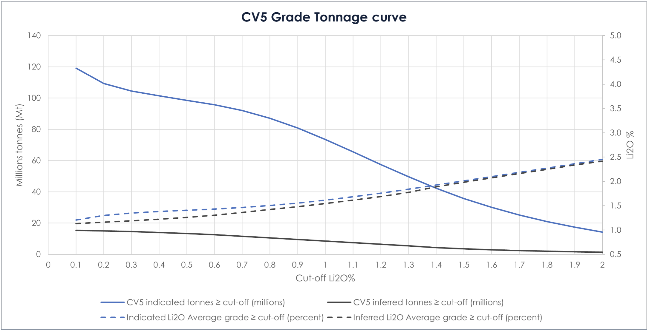
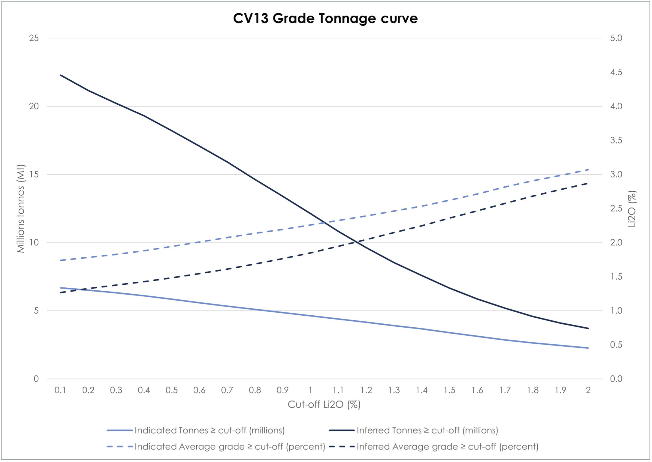
Figure 5: Shaakichiuwaanaan Mineral Resource grade-tonnage curves for the CV5 and CV13 spodumene pegmatites.
Tantalum
In addition to lithium as the primary commodity of interest, the CV5 and CV13 pegmatites also contain a significant amount of tantalum as a potentially recoverable by-product – 108.0 Mt at 1.40% Li2O and 166 ppm Ta2O5 Indicated, and 33.3 Mt at 1.33% Li2O and 156 ppm Ta2O5 Inferred. Potential mineable shapes are estimated based on the lithium cut-off grade only. Additionally, domaining of higher-grade tantalum zones within the overall pegmatite have not been incorporated into the MRE.
These tantalum grades are significant and rank Shaakichiuwaanaan as a top five tantalum pegmatite Mineral Resource in the world in terms of grade and tonnage (Figure 6).
Mineralogy completed to date indicates that tantalite is the tantalum-bearing mineral, which may be recoverable from the tailings of the primary lithium recovery process (i.e., potential valorization of waste streams). The Company is currently evaluating the potential for recovery of tantalum through an active mineral processing test program at SGS Canada’s Lakefield, ON, facility.
Tantalum is listed as a critical and strategic mineral by the province of Quebec (Canada), Canada, European Union, United Kingdom, Australia, Japan, India, South Korea, and the United States. Tantalum is a critical component required for a range of high-tech devices, electronics, and essential niche applications, including in capacitors as it has the highest capacitance of any metal. According to the United States Geological Survey, no significant amounts of tantalum are currently produced in North America or Europe, with a majority of production coming out of the Democratic Republic of Congo, Rwanda, and Brazil.
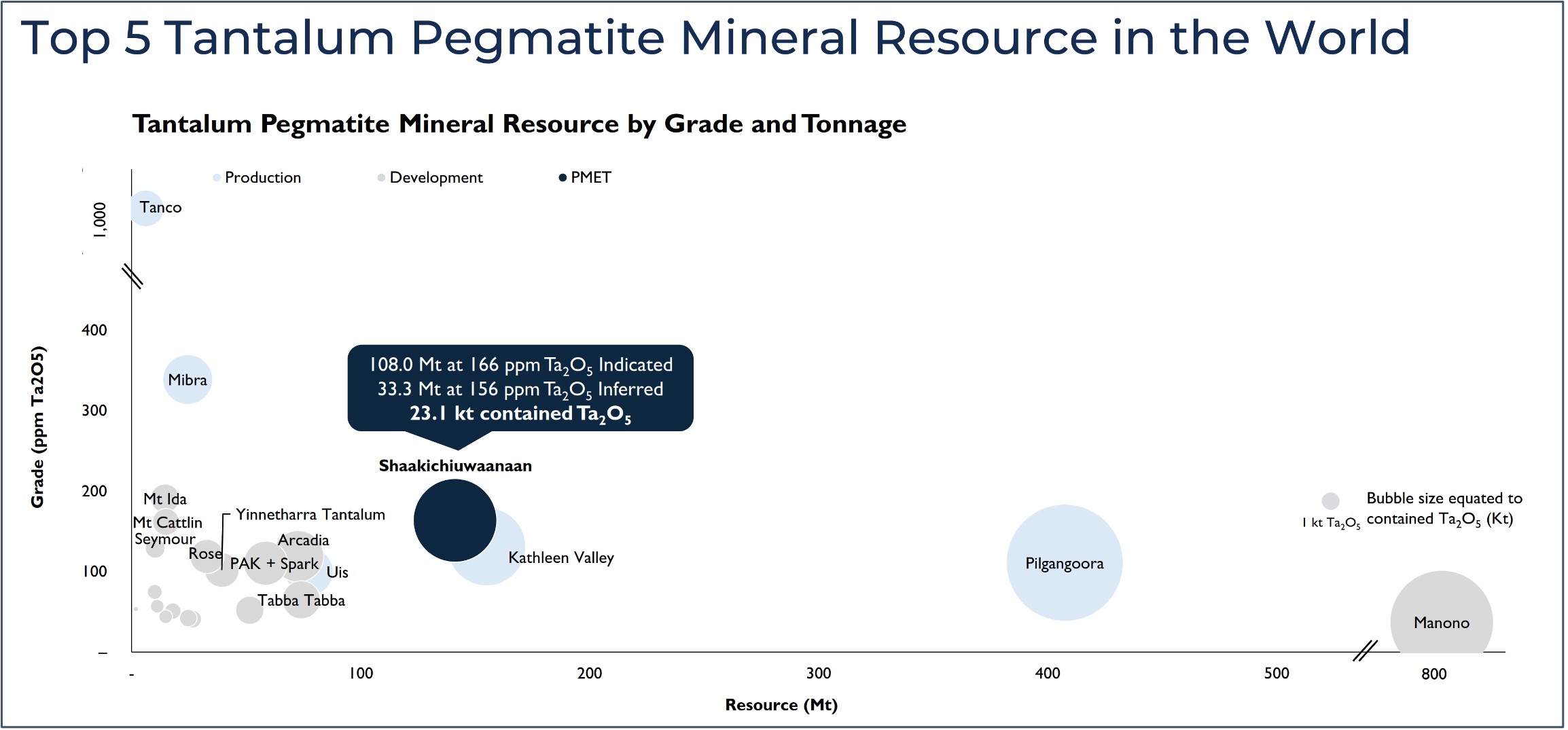
Figure 6: MRE tonnage vs grade chart highlighting Shaakichiuwaanaan as a top five tantalum pegmatite Mineral Resource globally. See comments under Figure 1 and Appendix 2 and 3 for further details and supporting information.
Gallium
As part of the Shaakichiuwaanaan MRE update, the Company has included gallium (Ga) – 108.0 Mt at 1.40% Li2O, 166 ppm Ta2O5, and 66 ppm Ga, Indicated, and 33.3 Mt at 1.33% Li2O, 156 ppm Ta2O5, 65 ppm Ga, Inferred. The gallium grades were not used in generating the potential mineable shapes at CV5 and CV13. Potential mineable shapes are estimated based on the lithium cut-off grade only. Additionally, domaining of potentially higher-grade gallium zones within the overall pegmatite have not been incorporated into the MRE.
Although the recovery of gallium from pegmatite has yet to be commercialized, there is a growing interest in lithium pegmatite as a potential source. The vast majority of current gallium production comes from bauxite (aluminum ore) processing, whereby the Ga has substituted for aluminum (Al) and is extracted (at very low overall recovery) out of the spent liquor when concentrations have reached sufficient levels. However, as lithium pegmatites may contain several aluminum rich minerals in abundance (feldspar, muscovite, spodumene), Ga may be present in reasonable concentrations that may encourage extraction in downstream processing. The Company is currently evaluating a metallurgical approach to recover gallium from the lithium waste stream(s).
Gallium is listed as a critical and strategic mineral by the province of Quebec (Canada), Canada, European Union, United Kingdom, Australia, Japan, India, South Korea, and the United States. China dominates global production of gallium and in late 2024 banned all exports of the metal to the United States, thus highlighting security of supply concerns. Gallium is used in various high-tech applications and primarily in the electronics industry as semiconductors.
Cesium
In news releases dated March 2 and April 9, 2025, the Company announced the discovery of significant cesium mineralization at the CV13 Pegmatite within the Vega and Rigel zones. Initial drill results returned 11.1 m at 4.87% Cs2O, including 7.1 m at 7.39% Cs2O (Vega, CV24-520) and 5.0 m at 13.32% Cs2O, including 2.0 m at 22.90% Cs2O (Rigel, CV23-255).
However, the MRE announced herein does not include cesium. This is in part due to the cesium overlimit analytical results being received after the determined Effective Date of the MRE announced herein (January 6, 2025), the geological modelling still required, as well as the overall ongoing Feasibility Study schedule requiring a frozen and classified block model earlier in the year. The Company anticipates advancing an updated Mineral Resource to include cesium in the CV13 Pegmatite as part of a future MRE update for the Project.
Cesium is listed as a critical and strategic mineral by the province of Quebec (Canada), Canada, Japan, and the United States. Mineral deposits of cesium (pollucite) are extremely rare globally and represent the most fractionated component of LCT pegmatite systems, which are effectively the only primary source of cesium globally. Due to its high-density, low toxicity, biodegradable nature, and recoverability, cesium is used to support the completion of oil and gas wells at high pressure and temperature. Cesium is also used in atomic clocks, GPS, aircraft guidance systems, and telecommunications.
Next Steps
With the updated MRE now completed, including a significant amount of Indicated Resource now estimated at CV5, the Company is focused on completion of the remaining deliverables for the Feasibility Study. The Feasibility Study, which includes only the CV5 Pegmatite (hosting the high-grade Nova Zone), remains on schedule for CYQ3-2025, with the Company recently announcing an update on its progress on March 18, 2025.
With respect to the cesium potential (see news releases dated March 2 and April 9, 2025), with the overlimit analysis now received, the Company is actively refining the geological models for the Vega and Rigel zones. An MRE update is anticipated to follow, which would include cesium, potentially later in 2025. Additionally, the Company will continue its exploratory drill program at CV13, focused on further delineation of the Vega and Rigel cesium zones. Various activities in support of potential development are also being considered.
Geological and Block Models
The geological model underpinning the MRE for CV5 interprets a single, steeply dipping (northerly), continuous, principal spodumene pegmatite body ranging in true thickness from <10 m to more than 125 m, extending over a strike length of approximately 4.6 km (drill hole to drill hole), which is flanked by multiple subordinate lenses. At CV5, the pegmatite may extend from surface to depths of more than 450 m in some locations and remains open in multiple directions.
The geological model underpinning the MRE for CV13 interprets a series of flat-lying to moderately dipping (northerly), sub-parallel trending spodumene pegmatite bodies, of which three appear to dominate. The pegmatite ranges in true thickness from <5 m to more than 40 m, extends over a strike length of approximately 2.5 km, and remains open in several directions.
The geological models of the CV5 and CV13 spodumene pegmatites are presented in plan, inclined, and side view in Figure 7, as well as Figure 8 to Figure 12, and Figure 20 and Figure 21, respectively. The MRE block model, block classifications, and cross-sections for CV5 and CV13 are presented in Figure 13 to Figure 19, and Figure 22 to Figure 29, respectively.
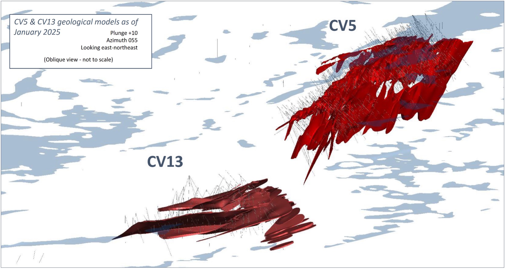
Figure 7: Oblique view (looking east-northeast) of CV5 and CV13 spodumene pegmatite geological models – all lenses.
CV5 Spodumene Pegmatite
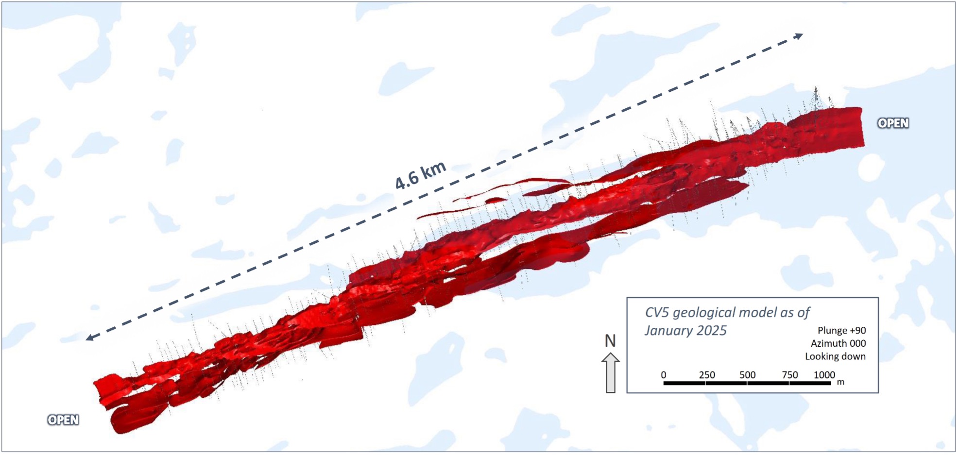
Figure 8: Plan view of CV5 Spodumene Pegmatite geological model – all lenses.
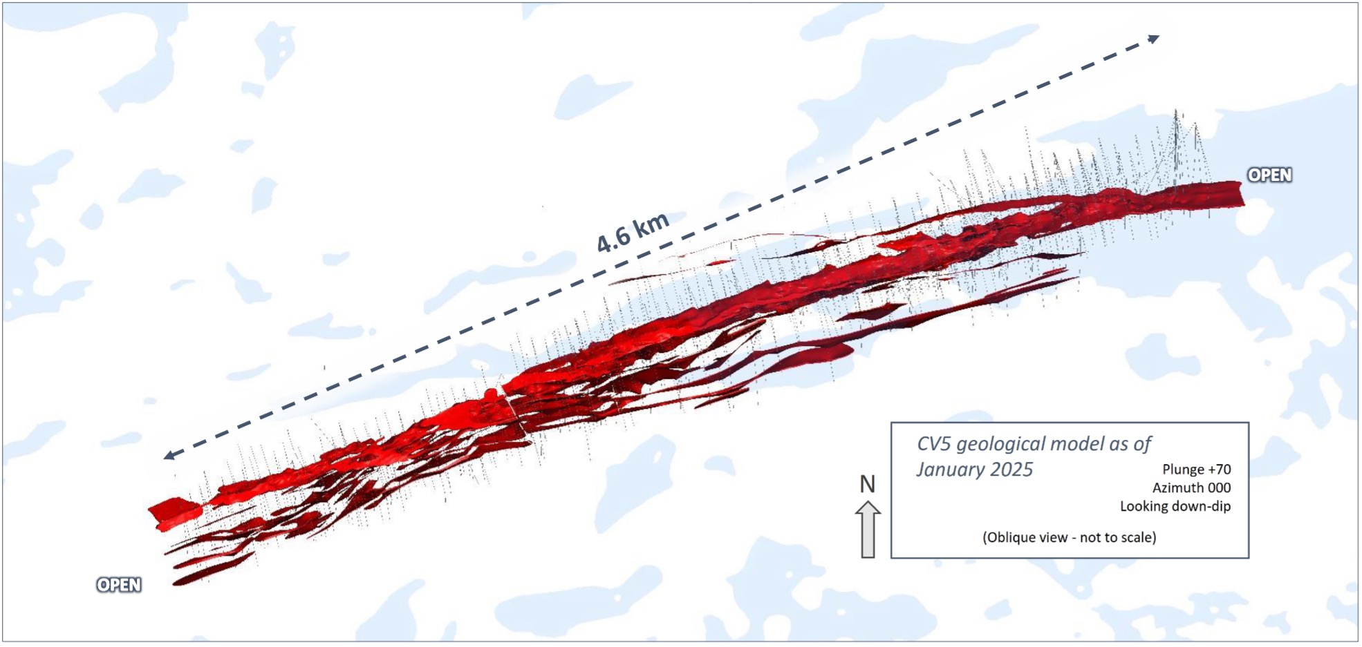
Figure 9: Inclined view of CV5 Spodumene Pegmatite geological model looking down dip (70°) – all lenses.
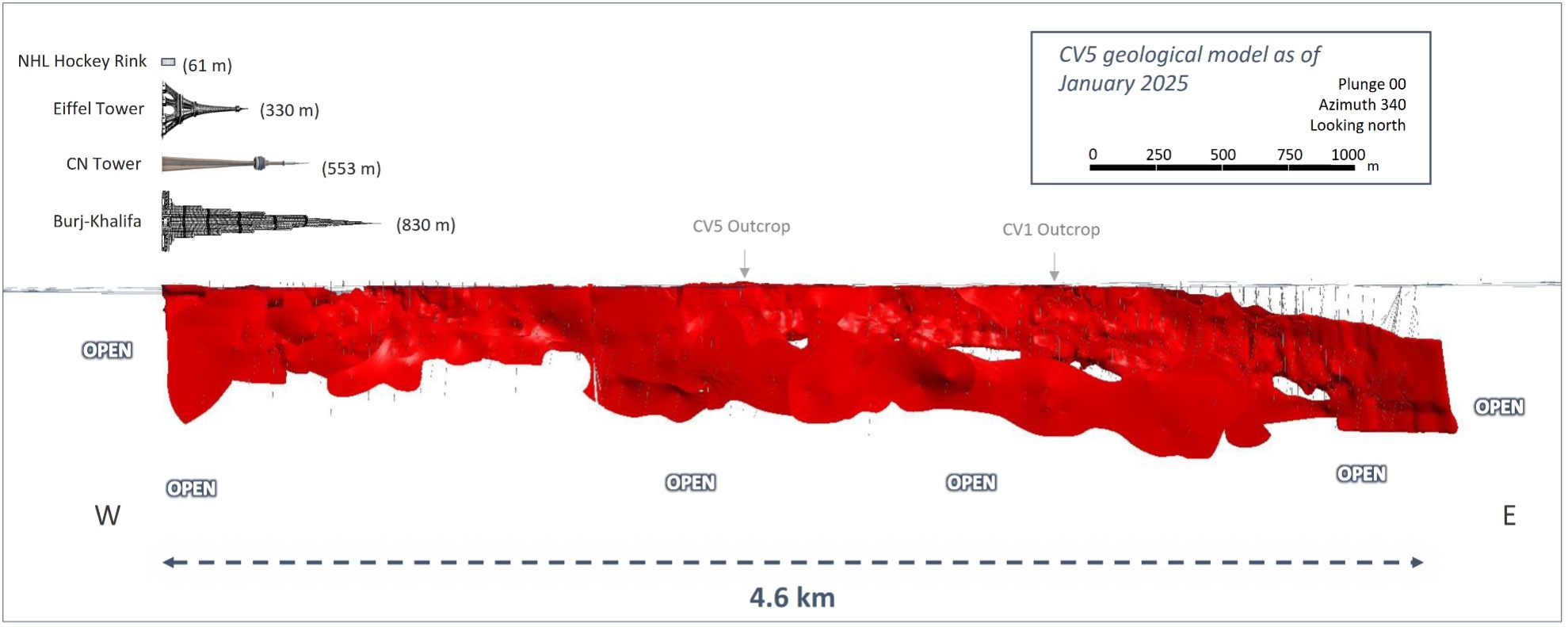
Figure 10: Side view of CV5 geological model looking north (340°) – all lenses – illustrating the scale of the CV5 Spodumene Pegmatite.
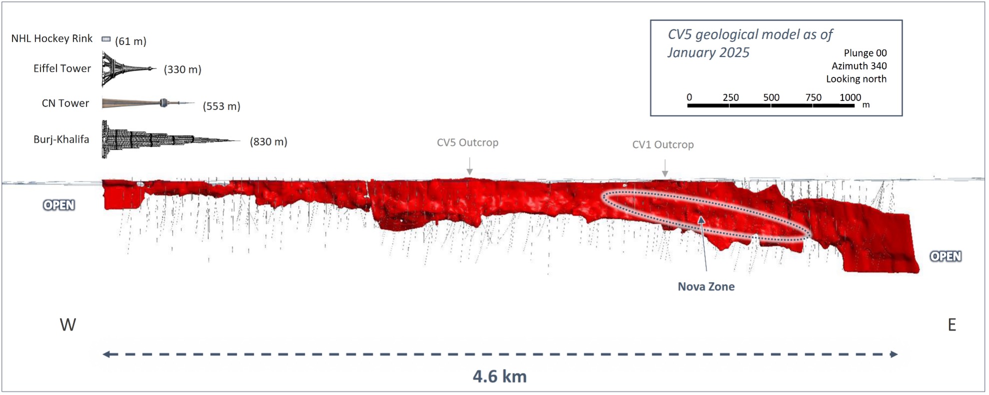
Figure 11: Side view of CV5 geological model looking north (340°) – principal pegmatite only.
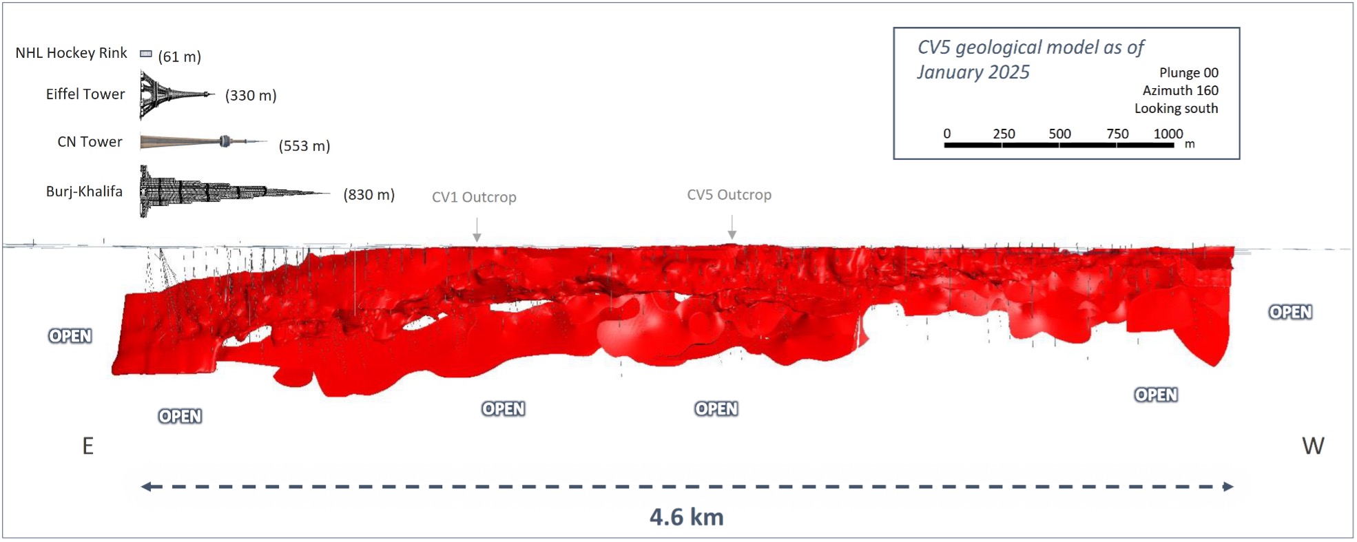
Figure 12: Side view of CV5 geological model looking south (160°) – all lenses.
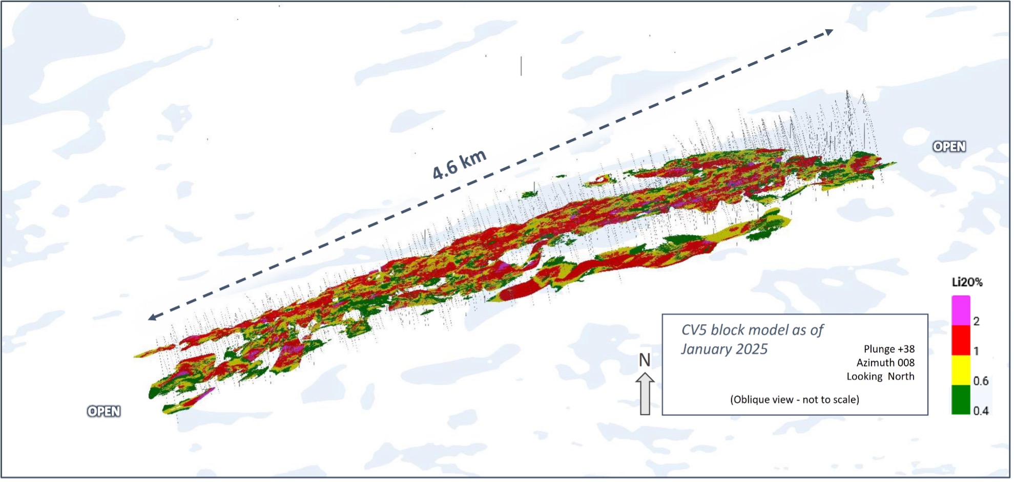
Figure 13: Oblique view of the CV5 Spodumene Pegmatite block model (unconstrained).
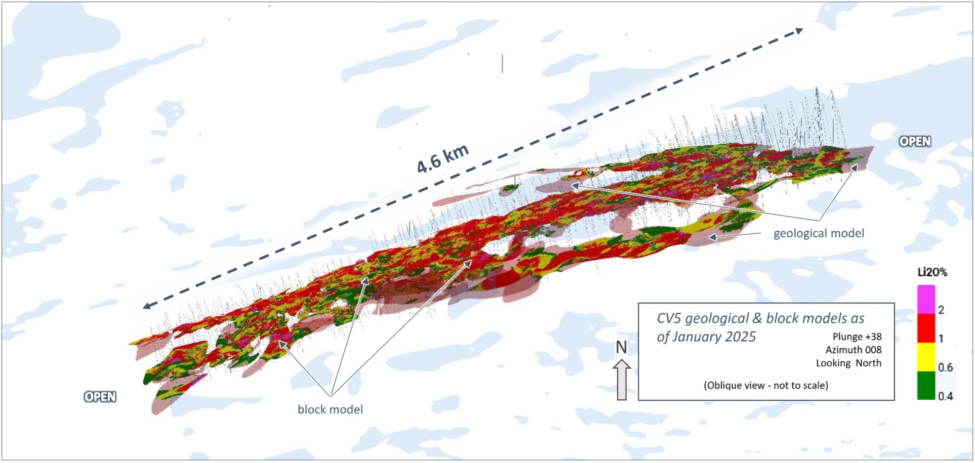
Figure 14: Oblique view of the CV5 Spodumene Pegmatite block model (unconstrained) overlaid with geological model (semi-transparent light red).
Geologically modelled pegmatite where blocks do not populate, have not reached the threshold confidence for the Inferred Mineral Resource category based on the classification criteria and/or mining constraint shape applied. Additional drilling is required to elevate confidence to the threshold allowing for an inferred classification of grade and tonnage to be assigned, and for these blocks to fall within a conceptual mining constraint shape required to satisfy reasonable prospects for eventual economic extraction (“RPEEE”) in accordance with NI 43-101.
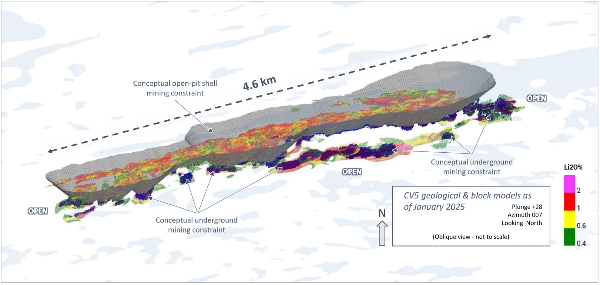
Figure 15: Oblique view of the CV5 Spodumene Pegmatite block model with respect to applied open-pit and underground conceptual mining constraint shapes.
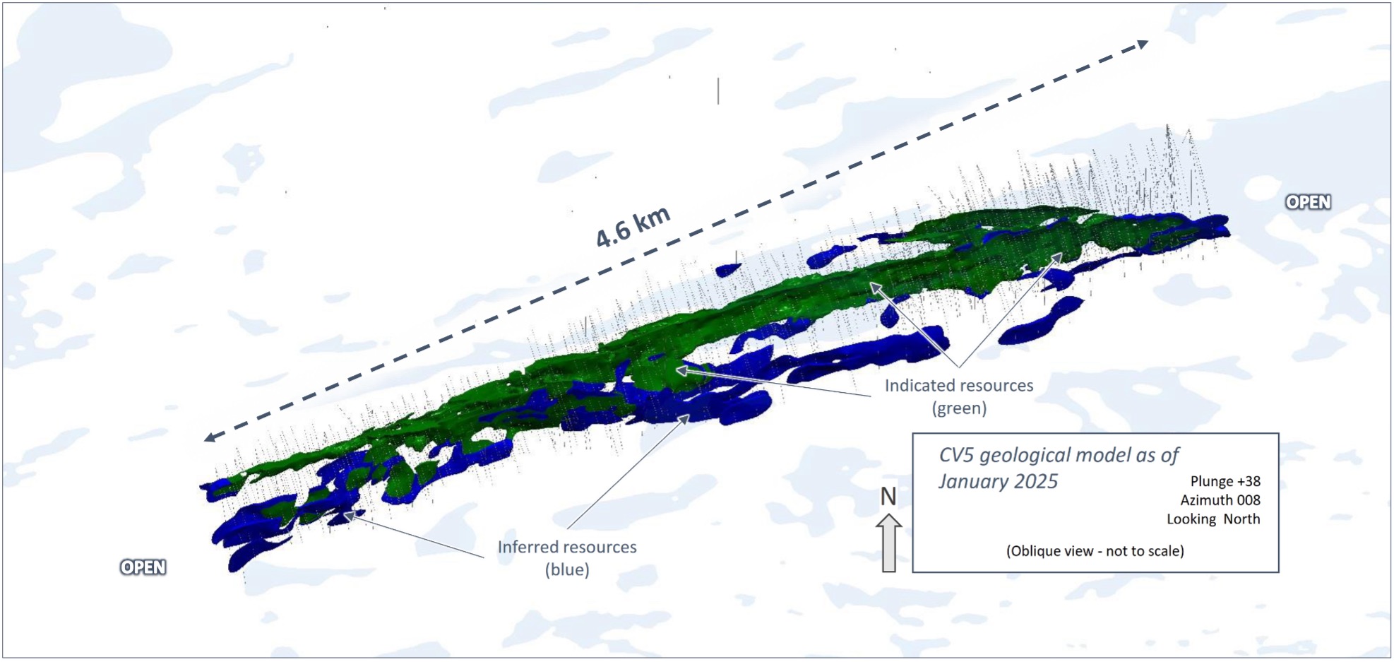
Figure 16: Oblique view of the global Indicated (green) and Inferred (blue) block model classifications for the CV5 Spodumene Pegmatite.
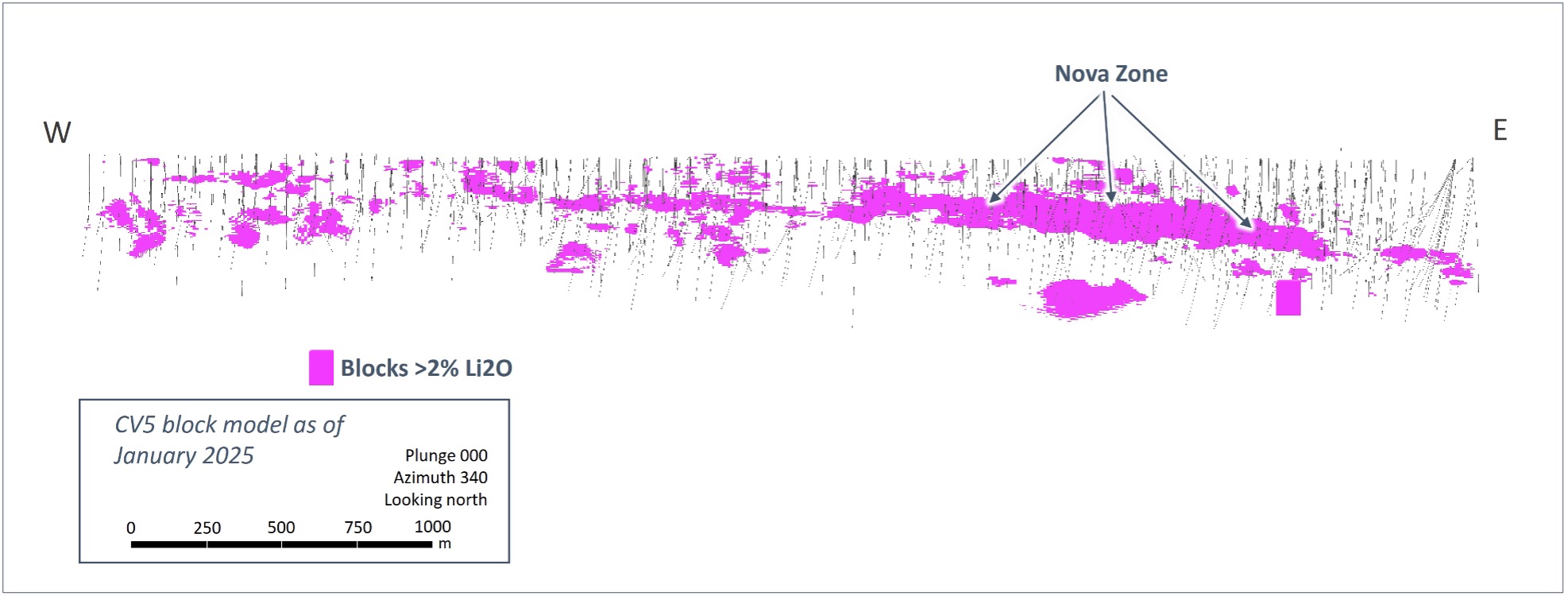
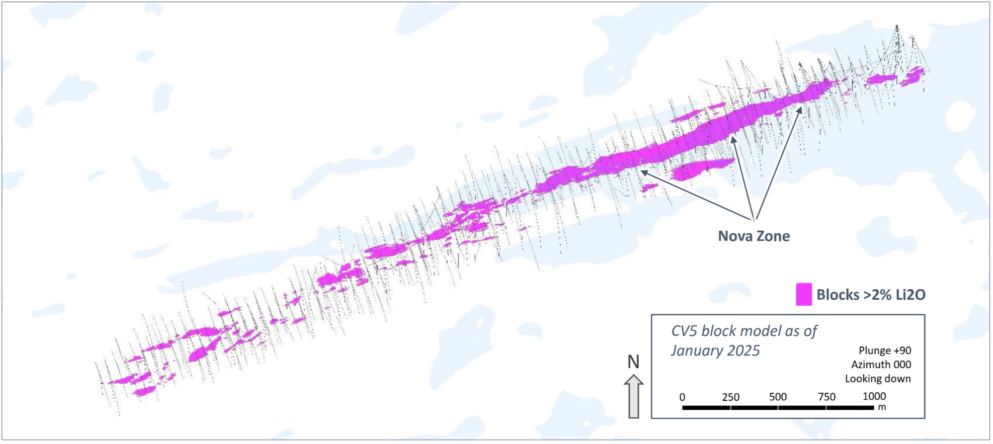

Figure 17: Select views of classified block model (CV5) highlighting the Nova Zone and continuity of high-grade mineralization along strike (blocks >2% Li2O at top and middle, blocks >3% Li2O at bottom).
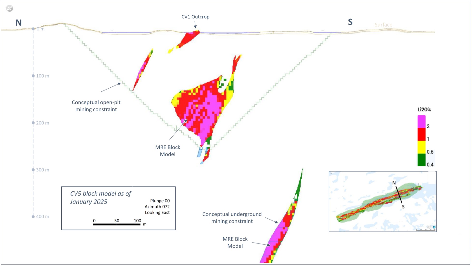
Figure 18: Cross-section of the CV5 Spodumene Pegmatite block model (Nova Zone) with conceptual mining constraint shapes.
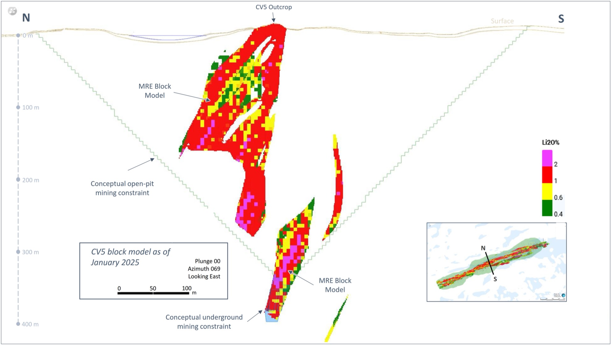
Figure 19: Cross-section of the CV5 Spodumene Pegmatite block model with conceptual mining constraints shapes.
CV13 Spodumene Pegmatite
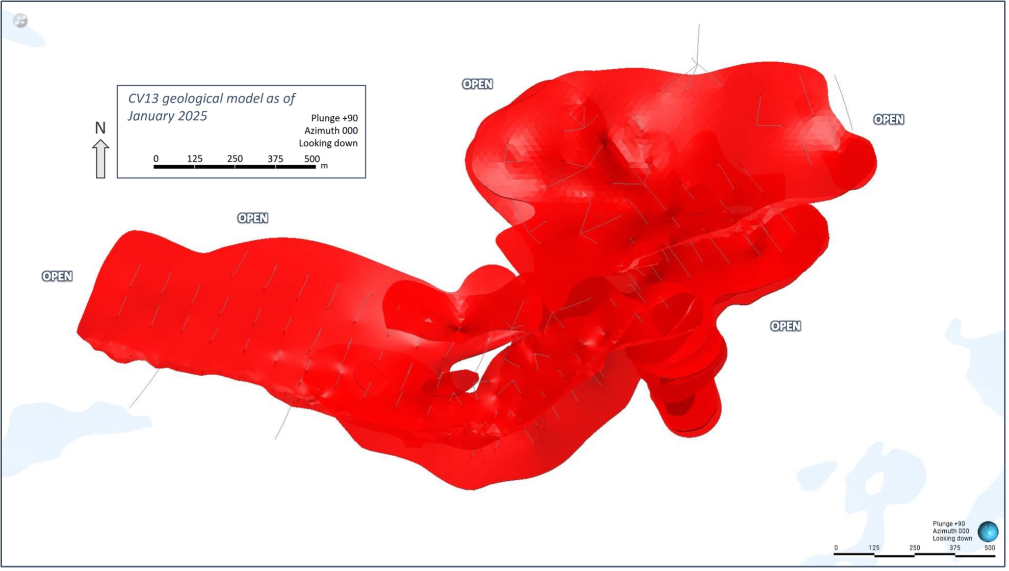
Figure 20: Plan view of CV13 Spodumene Pegmatite geological model – all lenses.
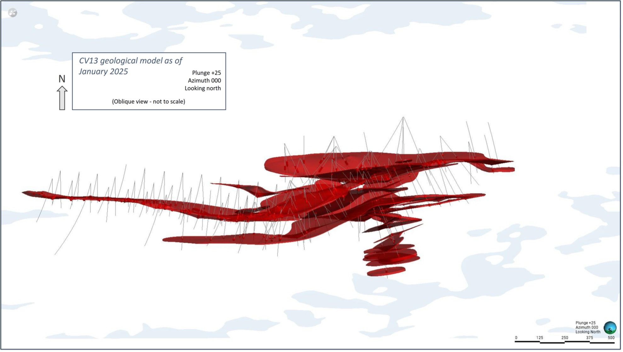
Figure 21: Inclined view of CV13 Spodumene Pegmatite geological model looking down dip (25°) – all lenses.
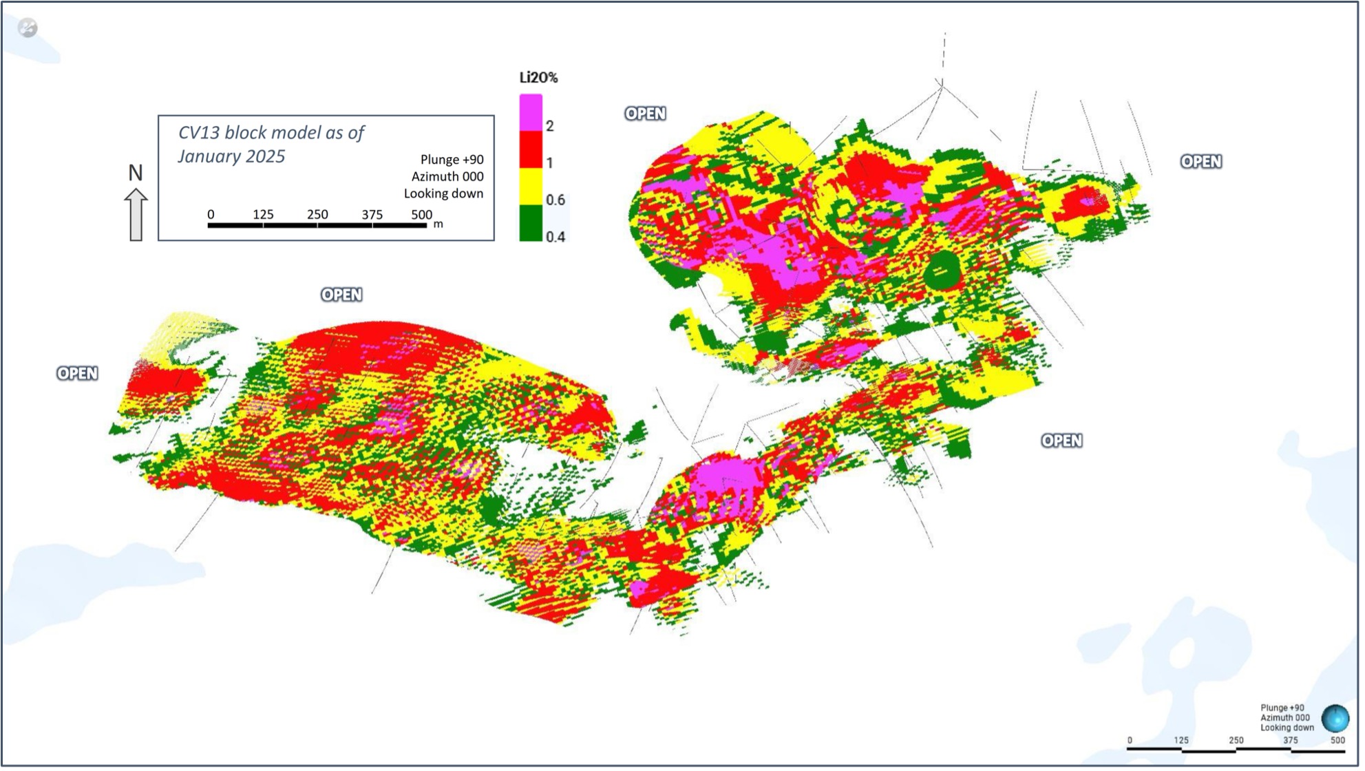
Figure 22: Plan view of the CV13 Spodumene Pegmatite block model (unconstrained)
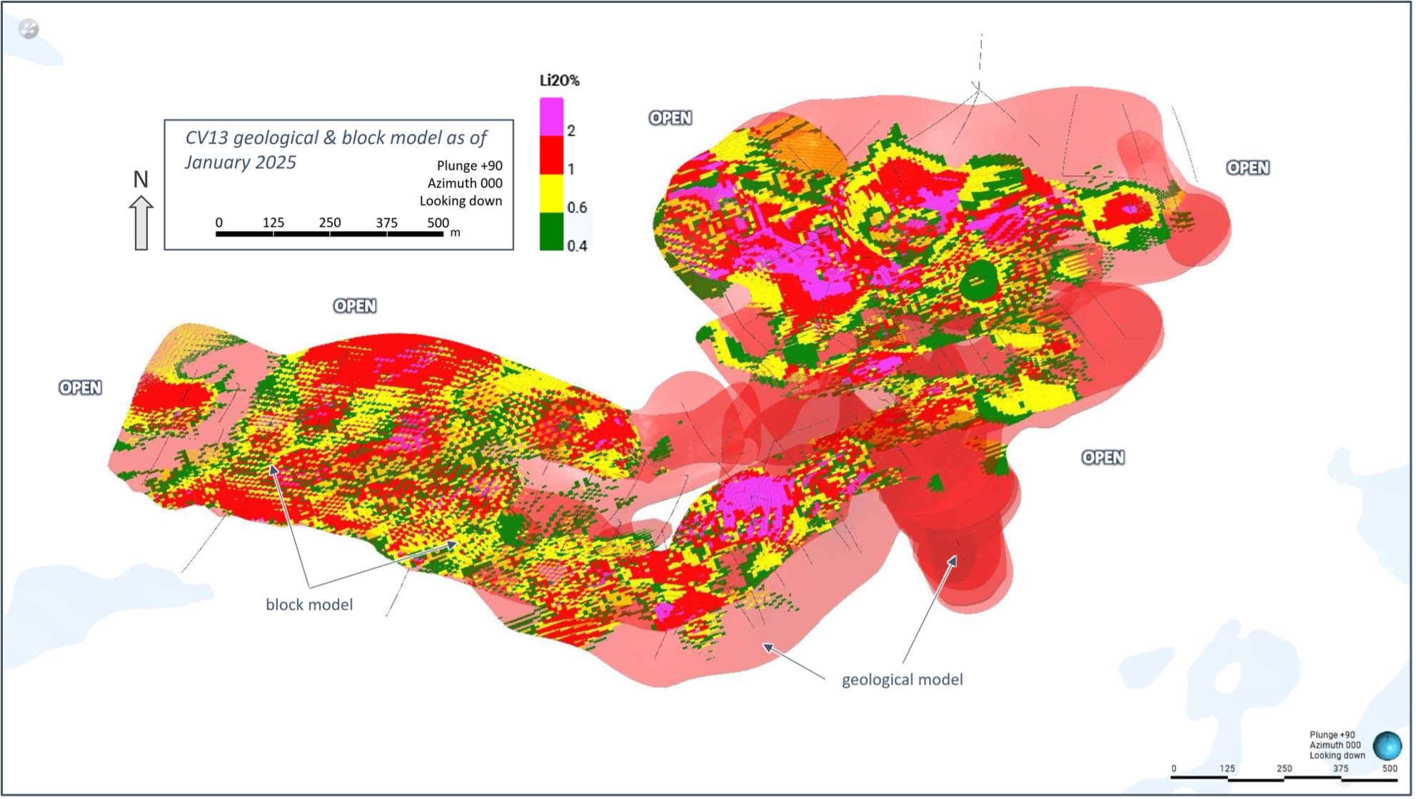
Figure 23: Plan view of the CV13 Spodumene Pegmatite block model (unconstrained) overlaid with geological model (semi-transparent light red).
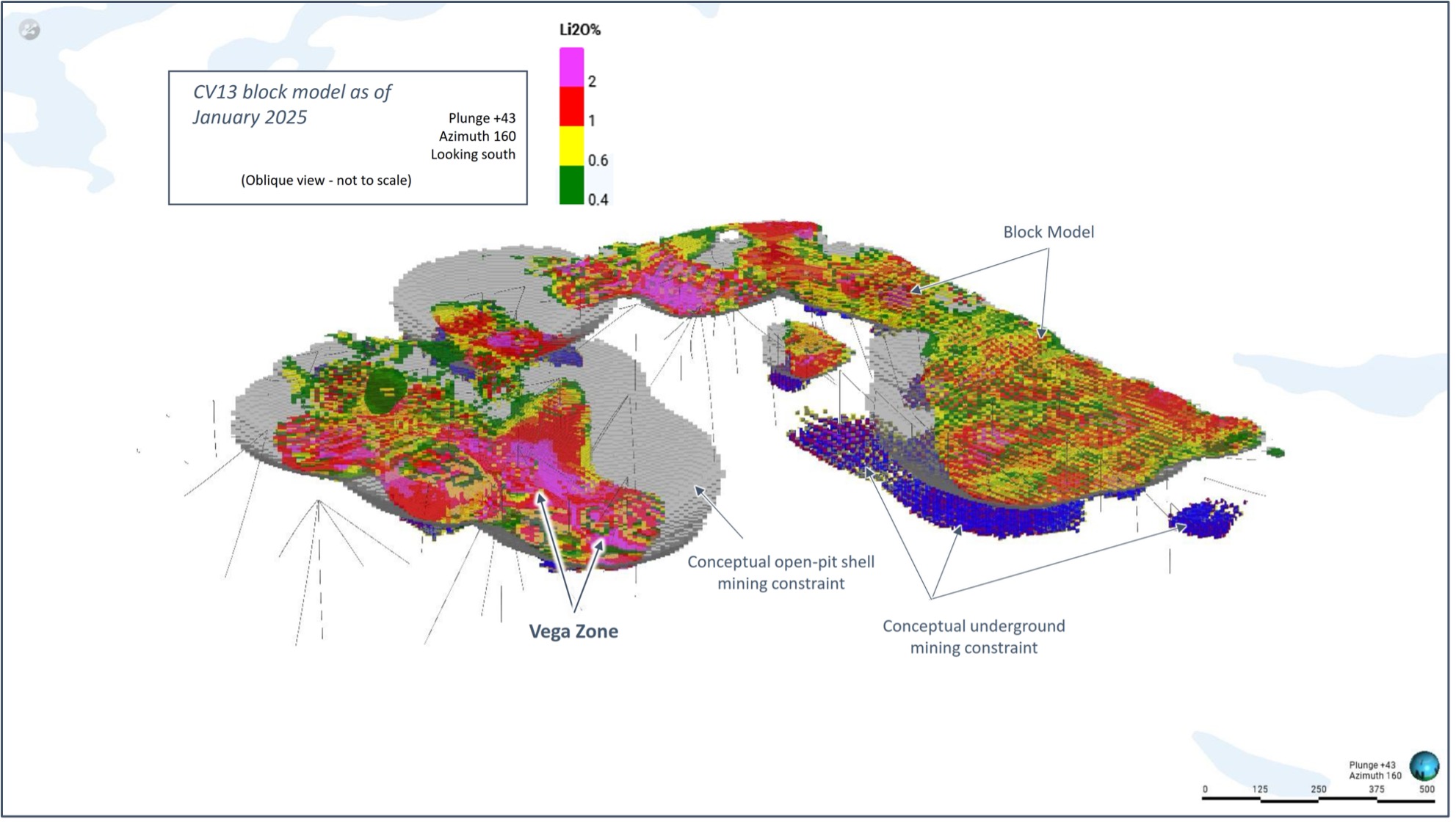
Figure 24: Oblique view of the CV13 Spodumene Pegmatite block model (classified & constrained) with respect to applied open-pit and underground conceptual mining constraint shapes.
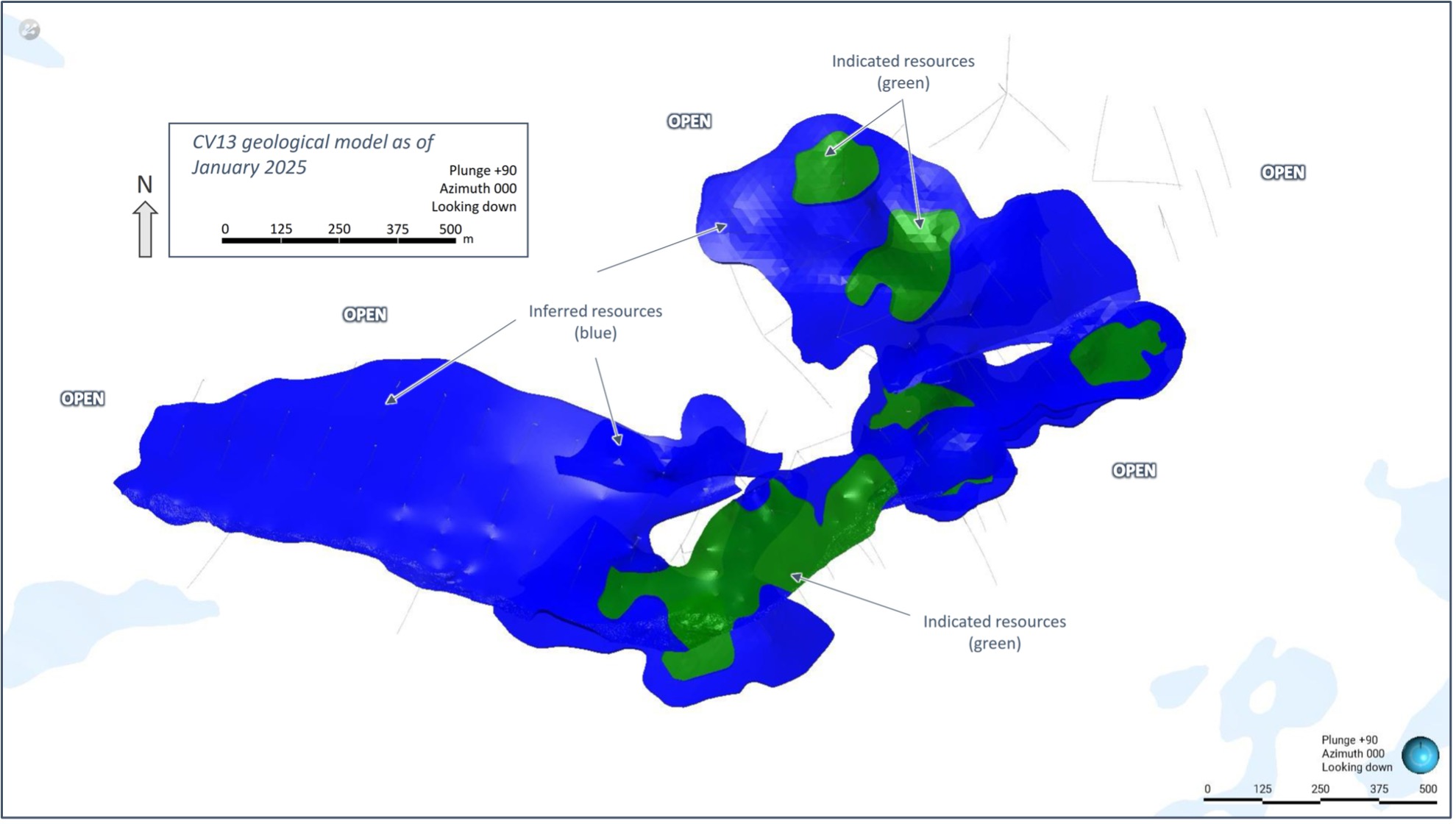
Figure 25: Plan view of the global Indicated (green) and Inferred (blue) block model classifications for the CV13 Spodumene Pegmatite.
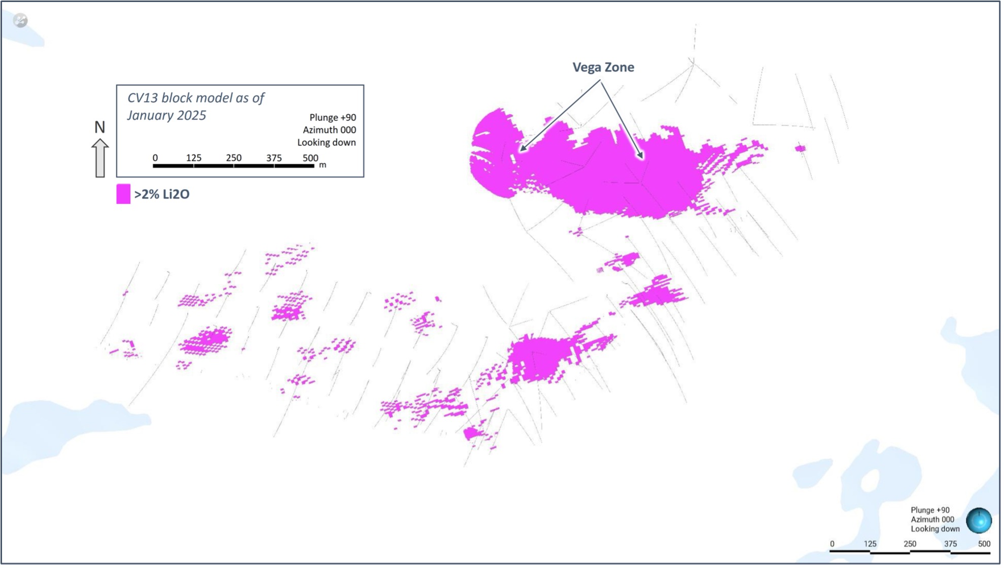
Figure 26: Plan view of the CV13 Spodumene Pegmatite block model with >2% Li2O blocks presented.
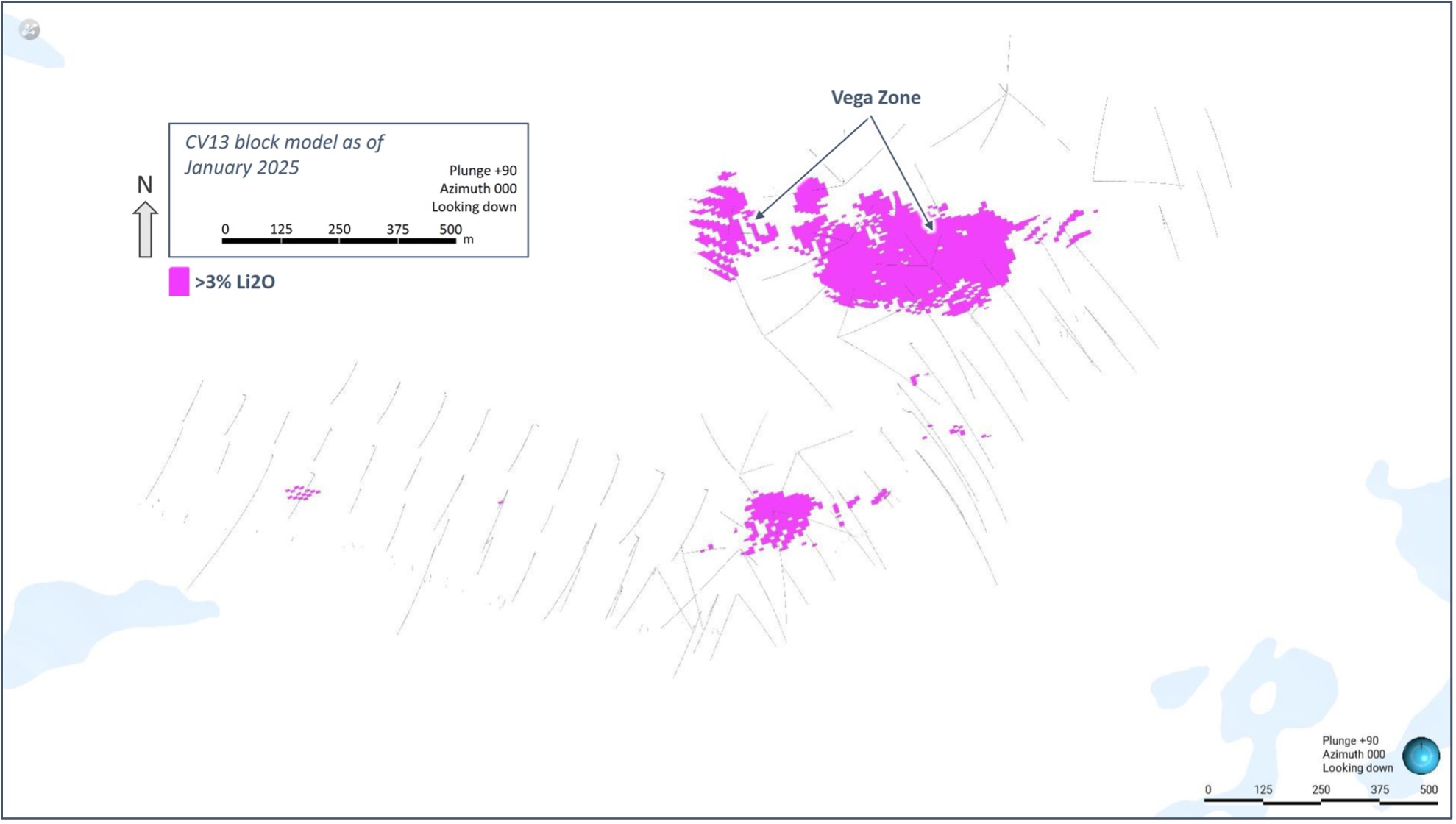
Figure 27: Plan view of the CV13 Spodumene Pegmatite block model, highlighting the Vega Zone, with >3% Li2O blocks presented.
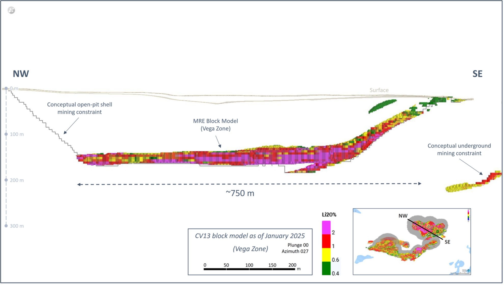
Figure 28: Cross-section of the CV13 Spodumene Pegmatite block model (Vega Zone, constrained), with conceptual open-pit constraint shapes.
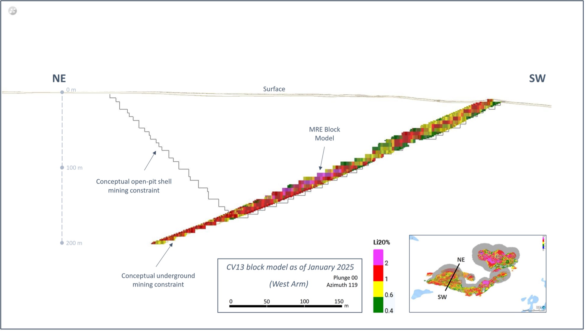
Figure 29: Cross-section of the CV13 Spodumene Pegmatite block model (west arm, constrained) with conceptual open-pit and underground constraint shapes.
ASX Listing Rule 5.8
As the Company is listed on both the Toronto Stock Exchange (the “TSX”) as well as the Australian Securities Exchange (the “ASX”), there are two applicable regulatory bodies resulting in additional disclosure requirements. This MRE has been completed in accordance with the Canadian National Instrument 43-101 – Standards of Disclosure for Mineral Projects. Additionally, in accordance with ASX Listing Rule 5.8 and the JORC 2012 reporting guidelines, a summary of the material information used to estimate the Mineral Resource for the Shaakichiuwaanaan Project is detailed below. For additional information, please refer to JORC Table 1, Section 1, 2, and 3, as presented in Appendix 1 of this announcement.
Mineral Title
The Shaakichiuwaanaan Property is located approximately 220 km east of Radisson, QC, and 240 km north-northeast of Nemaska, QC. The northern border of the Property’s primary claim grouping is located within approximately 6 km to the south of the Trans-Taiga Road and powerline infrastructure corridor (Figure 30). The La Grande-4 (LG4) hydroelectric dam complex is located approximately 40 km north-northeast of the Property. The CV5 Spodumene Pegmatite is located central to the Property, ~13 km south of KM-270 on the Trans-Taiga Road, and is accessible year-round by all-season road. The CV13 Spodumene Pegmatite is located ~3 km west-southwest of CV5.
The Property is comprised of 463 CDC mineral claims that cover an area of approximately 23,710 ha. All claims are registered 100% in the name of Lithium Innova Inc., a wholly owned subsidiary of Patriot Battery Metals Inc.
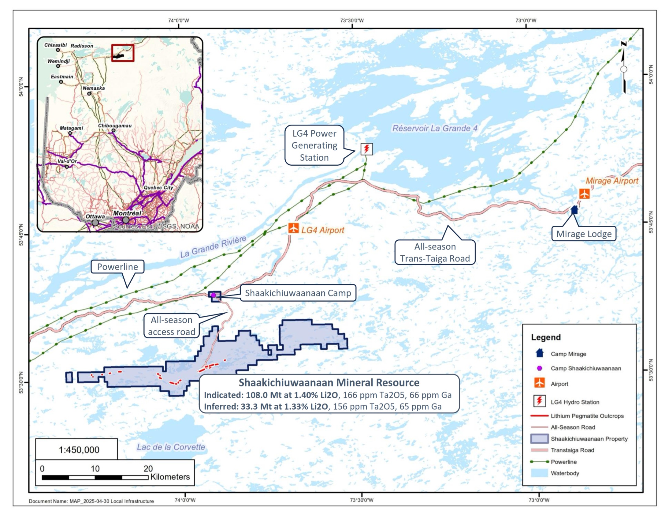
Figure 30: Shaakichiuwaanaan Property and regional infrastructure.
Geology and Geological Interpretation
The Property overlies a large portion of the Lac Guyer Greenstone Belt, considered part of the larger La Grande River Greenstone Belt, and is dominated by volcanic rocks metamorphosed to amphibolite facies. Rocks of the Guyer Group (amphibolite, iron formation, intermediate to mafic volcanics, peridotite, pyroxenite, komatiite, as well as felsic volcanics) predominantly underly the Property (Figure 35). The amphibolite rocks that trend east-west (generally steeply south dipping) through this region are bordered to the north by the Magin Formation (conglomerate and wacke) and to the south by an assemblage of tonalite, granodiorite, and diorite, in addition to metasediments of the Marbot Group (conglomerate, wacke) in the areas proximal to the CV5 Spodumene Pegmatite. Several regional-scale Proterozoic gabbroic dykes also cut through portions of the Property (Lac Spirt Dykes, Senneterre Dykes). The lithium pegmatites on the Property are hosted predominantly within amphibolites, metasediments, and to a lesser extent ultramafic rocks.
Exploration of the Property has outlined three primary mineral exploration trends, crossing dominantly east-west over large portions of the Property – Golden Trend (gold), Maven Trend (copper, gold, silver), and CV Trend (Li-Cs-Ta Pegmatite). The Golden Trend is focused over the northern areas of the Property, the Maven Trend in the southern areas, and the CV Trend “sandwiched” between. Historically, the Golden Trend has received the exploration focus followed by the Maven Trend. However, the identification of the CV Trend and the numerous lithium-tantalum pegmatites discovered to date, represents a previously unknown lithium pegmatite district that was first identified in 2016/2017 by Dahrouge Geological Consulting Ltd. and the Company.
At the Property, including CV5 and CV13, lithium mineralization is observed to occur within lithium-cesium-tantalum (“LCT”) pegmatites, which may be exposed at surface as both low and high relief landforms (i.e., outcrops) or present under shallow glacial till cover (Figure 31 and Figure 33). To date, the LCT pegmatites at the Property have been observed to occur within a corridor of generally ~1 km in width that extends in a general east-west direction across the Property for at least 25 km – the ‘CV Lithium Trend’ – with significant areas of prospective trend that remain to be assessed. To date, nine (9) distinct lithium pegmatite clusters have been reported along the CV Lithium Trend at the Property – CV4, CV5, CV8, CV9, CV10, CV12, CV13, CV14, and CV15.
The MRE reported herein is limited to only the CV5 and CV13 spodumene pegmatites (Figure 4), and represent the core area of the trend. The CV5 and CV13 pegmatites are situated along the same geological trend, with approximate strike lengths of 4.6 km and 2.5 km, respectively – as defined by drilling to date and which remain open – and are separated by a distance of ~2.6 km (Figure 4). The MRE covers ~6.9 km of the ~7.1 km of defined pegmatite trend and remains open.
The pegmatites at the Property, including CV5 and CV13, are very coarse-grained and off-white in appearance, with darker sections commonly composed of mica and smoky quartz, and occasionally tourmaline (Figure 32 and Figure 34). Spodumene is the dominant lithium-bearing mineral identified at all the lithium occurrences documented to date. It occurs as typically centimetre to decimetre-scale crystals that may exceed 1.5 m in length and range in colour from cream-white, to light-grey, to light-green. Minor localized lepidolite has been observed in core and in a small number of lithium pegmatite outcrops. Additionally, both CV5 and CV13 host a significant tantalum component (tantalite). A large zone of cesium mineralization (pollucite) has also been identified at the CV13 Pegmatite.
To date, at the CV5 Spodumene Pegmatite, multiple individual spodumene pegmatite dykes have been geologically modelled. However, a vast majority of the Mineral Resource is hosted within a single, large, principal spodumene pegmatite dyke, which is flanked on both sides by multiple, subordinate, sub-parallel trending dykes. The CV5 Spodumene Pegmatite, including the principal dyke, is modelled to extend continuously over a lateral distance of at least 4.6 km and remains open along strike at both ends and to depth along a large portion of its length. The width of the currently known mineralized corridor at CV5 is at least 500 m, with spodumene pegmatite intersected at depths of more than 450 m in some locations (vertical depth from surface). The pegmatite dykes at CV5 trend west-southwest (approximately 250°/070° RHR), and therefore dip northerly, which is different than the host amphibolites, metasediments, and ultramafics which dip moderately in a southerly direction.
The principal spodumene pegmatite dyke at CV5 ranges from <10 m to more than 125 m in true width, and may pinch and swell aggressively along strike, as well as up and down dip. It is primarily the thickest at near-surface to moderate depths (<225 m), forming a relatively bulbous, elongated shape, which may flair to surface and to depth variably along its length. The pegmatites that define CV5 are relatively undeformed and very competent, although they have meaningful structural control.
The geological model underpinning the MRE for the CV13 Spodumene Pegmatite interprets a series of flat-lying to moderately dipping (northerly), sub-parallel trending spodumene pegmatite bodies, of which three appear to dominate. The pegmatite bodies are coincident with the apex of a regional structural flexure whereby the pegmatite manifests a west arm trending ~290° and an east arm trending ~230°. Drilling to date indicates the east arm includes significantly more pegmatite stacking compared to the west, and also carries a significant amount of the overall CV13 Pegmatite tonnage and grade, highlighted by the high-grade Vega Zone.
The CV13 Pegmatite ranges in true thickness from <5 m to more than 40 m and extends continuously over a collective strike length of approximately 2.5 km, along its west and east arms. The CV13 Spodumene Pegmatite, which includes all proximal pegmatite lenses, remains open along strike at both ends and to depth along a significant portion of its length. Spodumene mineralization in the primary dykes has been traced more than 450 m down-dip (west arm) and over 800 m down-dip (near flat-lying east arm). However, due to the flat-lying to shallow dips of the pegmatite bodies, the mineralization is only ~200 m vertical depth from surface.
Both the CV5 and CV13 spodumene pegmatites display internal fractionation along strike and up/down dip, which is evidenced by variation in mineral abundance including spodumene and tantalite. This is highlighted by the high-grade Nova Zone (CV5) and Vega Zone (CV13), each situated at the base of their respective pegmatite lenses, and traced over a significant distance with multiple drill hole intercepts (core length) ranging from 2 to 25 m (CV5) and 2 to 10 m (CV13) at >5% Li2O, respectively, each within a significantly wider mineralized zone of >2% Li2O (Figure 17 and Figure 27). The Vega Zone is situated approximately 6 km south-west and along geological trend of the Nova Zone. Both zones share several similarities including lithium grades and very coarse decimetre to metre size spodumene crystals. However, both pegmatite zones have distinct orientations whereby the Vega Zone is relatively flat-lying to shallow dipping while the Nova Zone is steeply dipping to vertical.
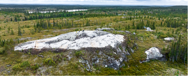
Figure 31: Principal spodumene pegmatite dyke outcropping at CV5 (looking southerly).
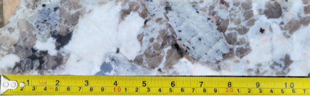
Figure 32: Drill core from CV5 (hole CV23-166A at depth of ~15 m) showing spodumene hosted within a quartz-feldspar pegmatite with accessory muscovite. No assay available as sample collected from within overburden (interpreted as frost heave). Visual estimates of mineral abundance should never be considered a proxy or substitute for laboratory analyses where concentrations or grades are the factor of principal economic interest. Visual estimates also potentially provide no information regarding impurities or deleterious physical properties relevant to valuations.
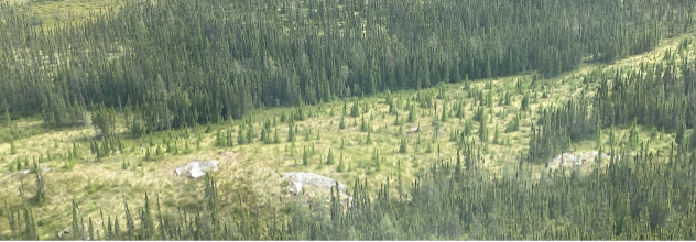
Figure 33: Spodumene pegmatite outcrop at CV13 (looking southerly).
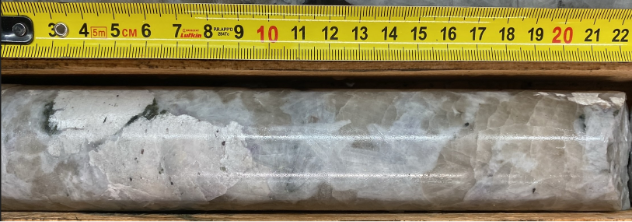
Figure 34: Spodumene pegmatite drill core from CV13 (hole CV24-524 at depth of ~159 m). Length of core in photo collected from interval grading 1.58% Li2O over 1.3 m.
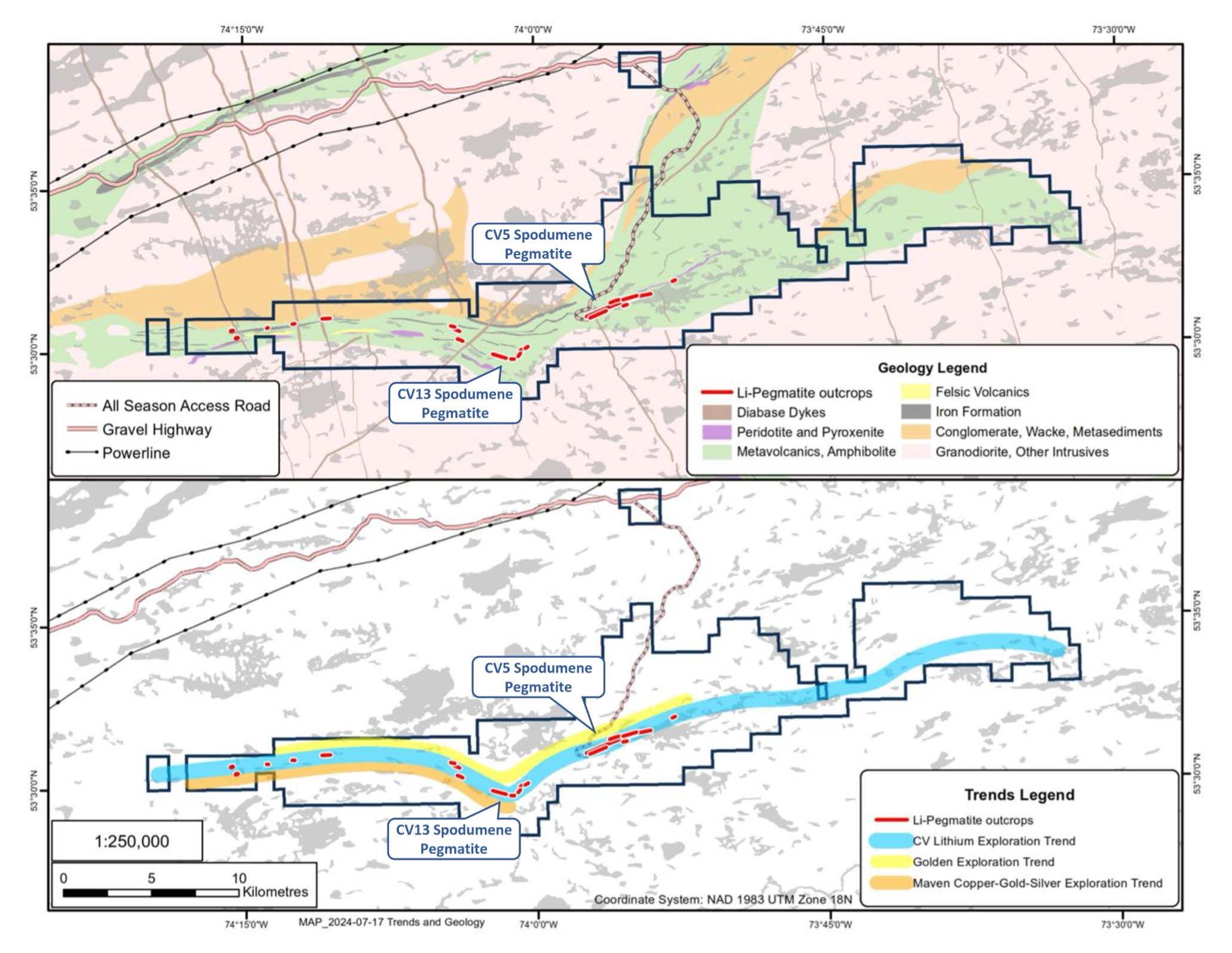
Figure 35: Property geology and mineral exploration trends.
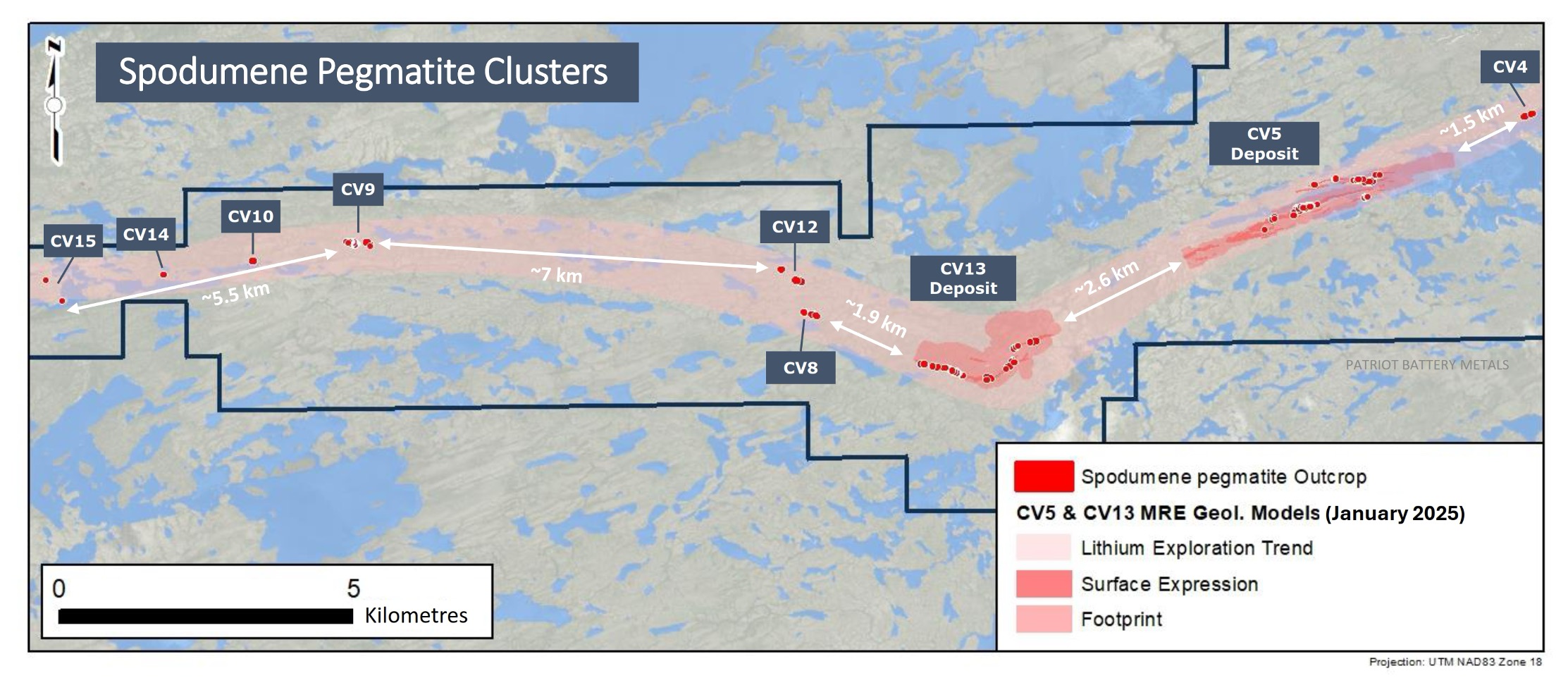
Figure 36: Spodumene pegmatite clusters at the Property discovered to date.
Drilling Techniques and Classification Criteria
The Shaakichiuwaanaan database includes 801 diamond drill holes completed over the 2021, 2022, 2023, and 2024 programs, for a collective total of 234,671 m, as well as outcrop channels totalling 800 m. The Shaakichiuwaanaan MRE, including the host geological models, are supported by 720 diamond drill holes of NQ (predominant) or HQ size, completed over the 2021, 2022, 2023, and 2024 (through the end of 2024 – drill hole CV24-787) programs, for a collective total of 227,703 m, as well 604 m of outcrop channels. This equates to 555 holes (188,695 m) and 179 m of outcrop channels at CV5, and 165 holes (39,008 m) and 425 m of outcrop channels at CV13 (Figure 37, Figure 38, and Figure 39).
Each drill hole collar was surveyed with an RTK tool (Topcon GR5 or Trimble Zephyr 3), with some minor exceptions that were surveyed using a handheld GPS (Garmin GPSMAP 64s) only (Table 4 and Table 5). Downhole deviation surveys for each drill hole were completed with a Devico DeviGyro tool (2021 and 2024 holes), Reflex Gyro Sprint IQ tool (2022, 2023, and 2024 holes), Axis Champ Gyro (2023 and 2024 holes), or Reflex OMNI Gyro Sprint IQ (2024 holes). Survey shots were typically continuous at approximate 3-5 m intervals. The use of the gyro tool system negated potential deflection issues arising from minor but common pyrrhotite within the host rock units. All collar and downhole deviation data have been validated by the project geologists on site, and by the database lead.
Drill core has not been oriented; however, downhole optical and acoustic televiewer surveys have been completed on multiple holes, at both CV5 and CV13, to assess overall structure. This data guided the current geological models supporting this MRE.
At CV5, drill hole collar spacing is dominantly grid based. Several collars are typically completed from the same pad at varied orientations targeting pegmatite pierce points of ~50 to 100 m spacing depending on the resource classification being targeted. Most holes completed to date are oriented southerly (typically 158°), to cross-cut perpendicular the steeply, northerly dipping pegmatite, apart from drill holes targeting specific structure or areas of the pegmatite.
At CV13, drill hole spacing is a combination of grid based (at ~100 m spacing) and fan based. Several collars are typically completed from the same pad at varied orientations targeting pegmatite pierce points of ~50 to 100 m spacing depending on the resource classification being targeted. Due to the varied orientation of the pegmatite bodies along strike at CV13, hole orientations vary widely with multiple holes often being completed from the same pad.
Drill hole spacing and orientation at the CV5 and CV13 pegmatites is sufficient to support the geological models and resource classifications applied herein.
All drill holes were completed by Fusion Forage Drilling Ltd. of Hawkesbury, ON. Procedures at the drill followed industry best practices with drill core placed in either 4 or 5 ft long, typically flat, square-bottom wooden boxes with the appropriate hole and box ID noted and block depth markers placed in the box. Core recovery typically exceeds 90%. Once full, the box was fibre taped shut with wooden lids at the drill and transported (helicopter or truck) to Mirage Lodge for processing.
Channel sampling followed industry best practices with a 3 to 5 cm wide, saw-cut channel completed across the pegmatite outcrop as practical, perpendicular to the interpreted pegmatite strike. Samples were collected at ~0.5 to 1 m contiguous intervals with the channel bearing noted, and GPS coordinate collected at the start and end points of the channel. Channel samples were transported along the same route as drill core for processing at Mirage Lodge.
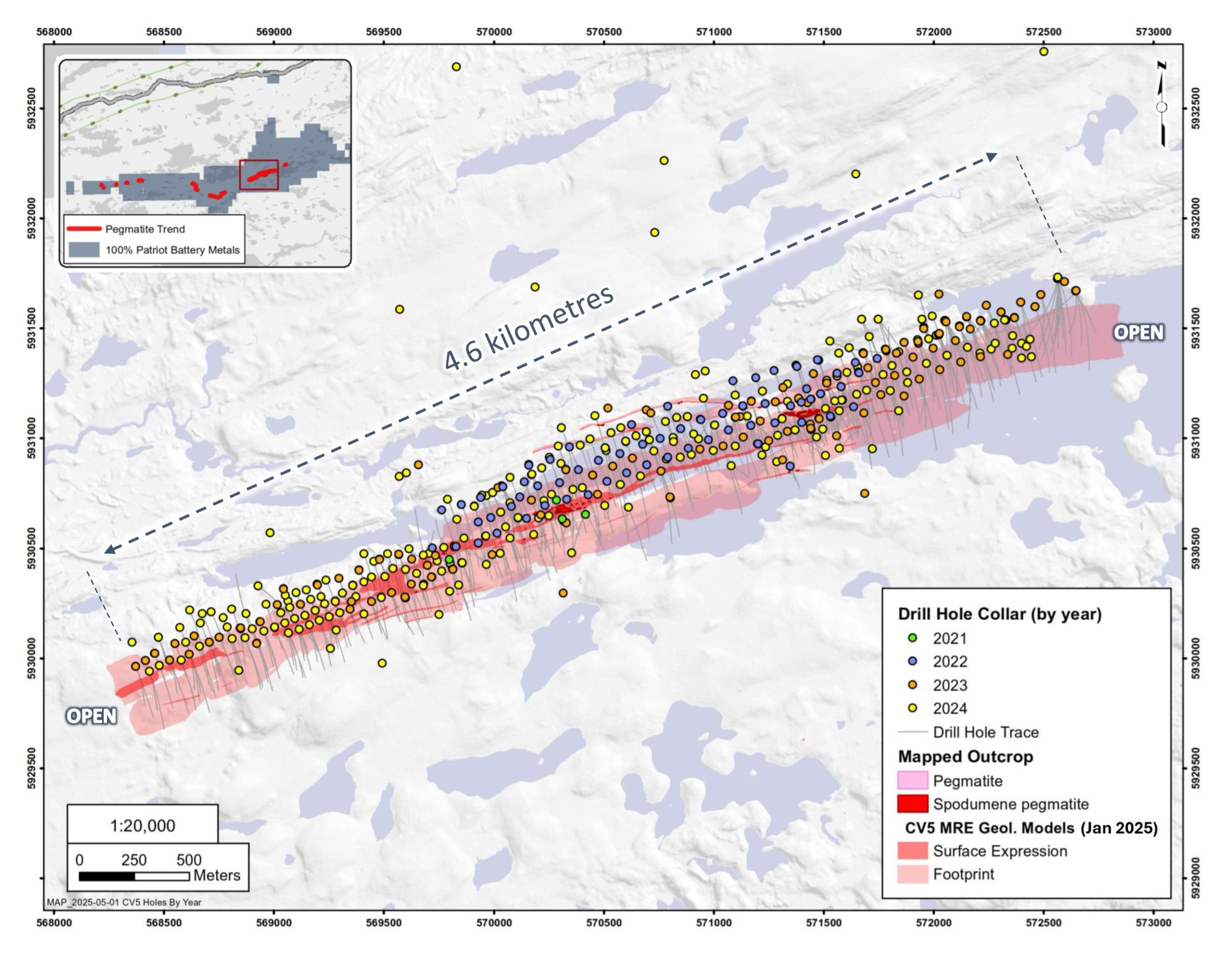
Figure 37: Diamond drill hole locations at the CV5 Spodumene Pegmatite, which form the basis of the MRE.
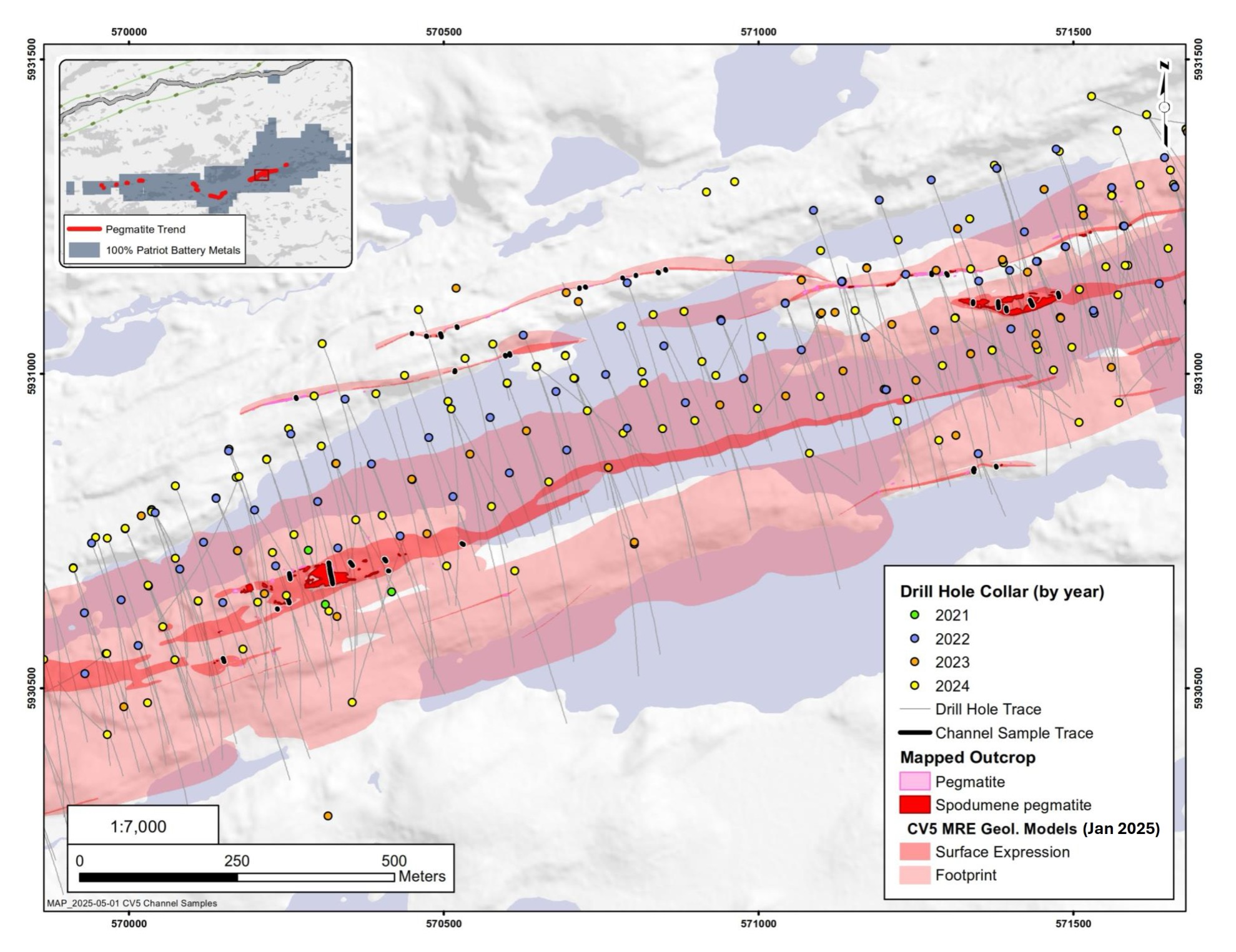
Figure 38: Channel locations at the CV5 Spodumene Pegmatite included in the MRE.
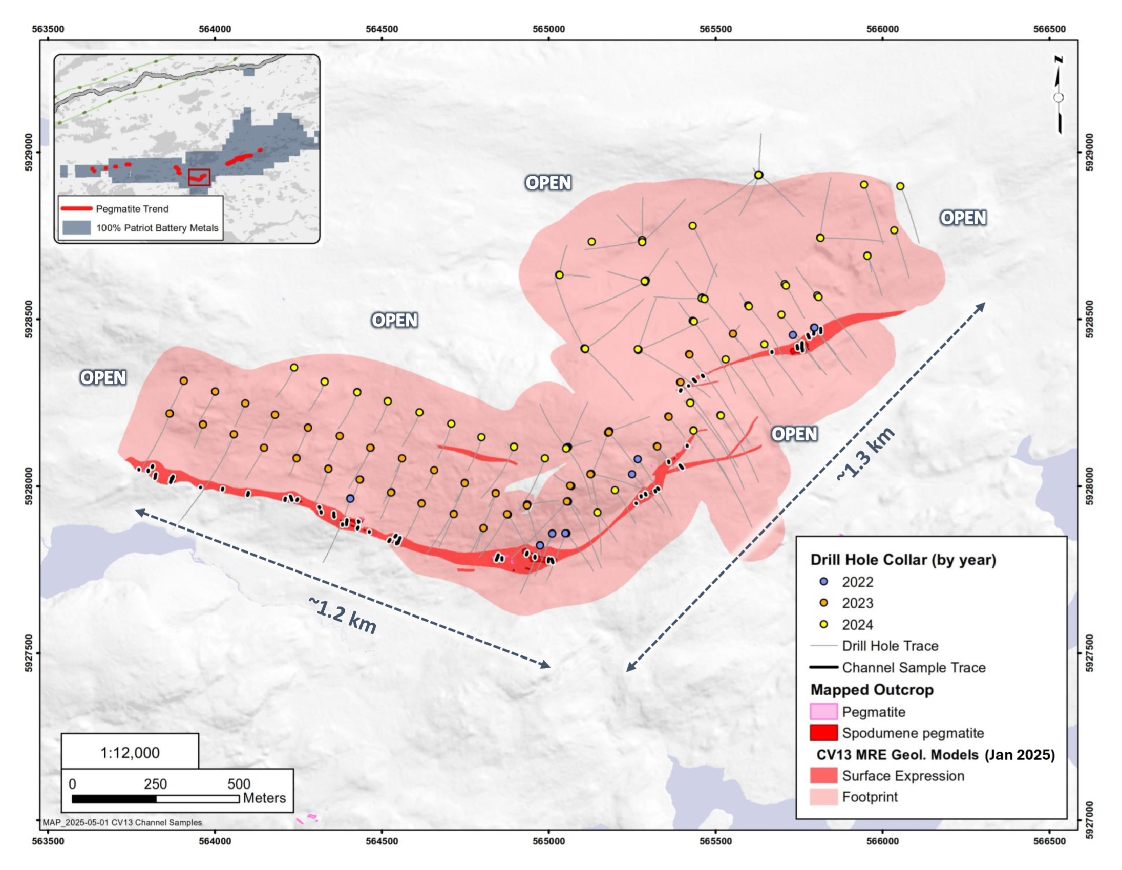
Figure 39: Diamond drill hole and channel locations at the CV13 Spodumene Pegmatite, which form the basis of the MRE.
Sampling and Sub-Sampling Techniques
Core sampling protocols meet industry standard practices. Upon receipt at the core shack at Mirage Lodge, all drill core is pieced together, oriented to maximum foliation, metre marked, geotechnically logged (TCR, RQD, ISRM, and Q-Method (since mid-winter 2023)), alteration logged, geologically logged (rock type), and sample logged on an individual sample basis. Wet and dry core box photos are also collected of all core drilled, regardless of perceived mineralization. Specific gravity (“SG”) measurements of entire pegmatite samples were collected at systematic intervals (approximately 1 SG measurement every 4-5 m) using the water immersion method. SG measurements are also collected systematically from host rock samples (i.e., non-pegmatite).
Core sampling was guided by rock type as determined during geological logging (i.e., by a geologist). All pegmatite intervals were sampled in their entirety, regardless of whether spodumene mineralization was noted or not (in order to ensure an unbiased sampling approach) in addition to ~1 to 3 m of sampling into the adjacent host rock (dependent on pegmatite interval length) to “bookend” the sampled pegmatite. The minimum individual sample length is typically 0.3-0.5 m and the maximum sample length is typically 2.0 m. Targeted individual pegmatite sample lengths are 1.0 to 1.5 m. All drill core was saw-cut, using an Almonte automatic core saw in 2022, 2023, and 2024 with one half-core collected for assay, and the other half-core remaining in the box for reference.
Channels were geologically logged upon collection on an individual sample basis; however, were not geotechnically logged. Channel recovery was effectively 100%.
The logging of drill core and channels was qualitative by nature, and included estimates of spodumene grain size, inclusions, and model mineral estimates. These logging practices meet or exceed current industry standard practices and are of appropriate detail to support a Mineral Resource estimation and disclosure herein.
All core samples were bagged and sealed individually, and then placed in large supersacs for added security, palleted, and shipped by third party transport, or directly by representatives of the Company, to the designated sample preparation laboratory (Activation Laboratories Ltd. (“Activation Laboratories”) in Ancaster, ON, in 2021, SGS Canada Inc. (“SGS Canada”) in either Lakefield, ON, Val-d’Or, QC, or Radisson, QC, in 2022, 2023, and 2024, being tracked during shipment along with chain of custody documentation. A small number of holes were sent for sample preparation to SGS Canada’s Sudbury, ON, and Burnaby, BC, facilities in 2022. Upon arrival at the laboratory, the samples were cross-referenced with the shipping manifest to confirm all samples were accounted for and had not been tampered with.
Sample Analysis Method and Quality Control
Core samples collected from 2021 drill holes were shipped to Activation Laboratories in Ancaster, ON, for standard sample preparation (code RX1) which included crushing to 80% passing 10 mesh, followed by a 250 g riffle split and pulverizing to 95% passing 105 microns. All 2021 core sample pulps were analyzed, at the same lab, for multi-element (including lithium) by four-acid digestion with ICP-OES finish (package 1F2) and tantalum by INAA (code 5B), with any samples returning >8,000 ppm Li by 1F2 reanalyzed for Li by code 8-4 Acid ICP Assay. Activation Laboratories is a commercial lab with the relevant accreditations (ISO 17025) and is independent of the Company.
Core samples collected from 2022 and 2023 drill holes CV22-015 through CV23-107 were shipped to SGS Canada’s laboratory in either Lakefield, ON (vast majority), Sudbury, ON (CV22-028, 029, 030), or Burnaby, BC (CV22-031, 032, 033, and 034), for standard sample preparation (code PRP89) which included drying at 105°C, crush to 75% passing 2 mm, riffle split 250 g, and pulverize 85% passing 75 microns. Core samples collected from 2023 drill holes CV23-108 through 365 were shipped to SGS Canada’s laboratory in Val-d’Or, QC, for standard sample preparation (code PRP89).
Core samples collected from 2024 drill holes were shipped to SGS Canada’s laboratory in either Val-d’Or, QC, or Radisson, QC, for a sample preparation (code PRP90 special) which includes drying at 105°C, crush to 90% passing 2 mm, riffle split 250 g, and pulverize 85% passing 75 microns.
All 2022, 2023, and 2024 (through drill hole CV24-787) core sample pulps were shipped by air to SGS Canada’s laboratory in Burnaby, BC, where the samples were homogenized and subsequently analyzed for multi-element (including Li and Ta) using sodium peroxide fusion with ICP-AES/MS finish (codes GE_ICP91A50 and GE_IMS91A50). SGS Canada is a commercial lab with the relevant accreditations (ISO 17025) and is independent of the Company.
A Quality Assurance / Quality Control (QAQC) protocol following industry best practices was incorporated into the drill programs and included systematic insertion of quartz blanks and certified reference materials into sample batches, as well as collection of quarter-core duplicates (through hole CV23-190 only), at a rate of approximately 5% each. Additionally, analysis of pulp-split and coarse-split (through hole CV23-365 only) sample duplicates were completed to assess analytical precision at different stages of the laboratory preparation process, and external (secondary) laboratory pulp-split duplicates were prepared at the primary lab for subsequent check analysis and validation at a secondary lab (SGS Canada in 2021, and ALS Canada in 2022, 2023, and 2024).
Channel samples collected in 2017 were shipped to SGS Canada’s laboratory in Lakefield, ON, for standard preparation. Pulps were analyzed at SGS Canada’s laboratory in either Lakefield, ON, (2017), or Burnaby, BC (2022), for multi-element (including Li and Ta) using sodium peroxide fusion with ICP-AES/MS finish. All subsequent channel samples were shipped to Val-d’Or, QC for standard sample preparation with the pulps shipped by air to SGS Canada’s laboratory in Burnaby, BC, where the samples were homogenized and subsequently analyzed for multi-element (including Li and Ta) using sodium peroxide fusion with ICP-AES/MS finish (codes GE_ICP91A50 and GE_IMS91A50).
A QAQC protocol following industry best practices was incorporated into the channel programs and included systematic insertion of quartz blanks and certified reference materials into sample batches.
Criteria Used for Classification
The Shaakichiuwaanaan resource classification has been completed in accordance with the NI 43-101, JORC 2012, and CIM Definition Standards for Mineral Resources and Reserves reporting guidelines. All reported Mineral Resources have been constrained by conceptual open-pit or underground mineable shapes to demonstrate reasonable prospects for eventual economic extraction (“RPEEE”).
Blocks were classified as Indicated when drill spacing was 70 m or lower, blocks were estimated with at least 2 drill holes, and meeting the minimum estimation criteria parameters. Geological continuity and a minimum thickness of 2 m were mandatory, as well grade continuity demonstrated at the reported cut-off grade.
Blocks were classified Inferred when drill spacing was between 70 m and 140 m and meeting the minimum estimation criteria parameters. Geological continuity and a minimum thickness of 2 m were also mandatory.
There are no measured classified blocks. Pegmatite dykes or extension with lower level of information / confidence were also not classified.
Classification shapes are created around contiguous blocks at the stated criteria with consideration for the selected mining method. The MRE appropriately reflect the view of the Competent Person.
Estimation Methodology
Compositing was done every 1.0 m. Unsampled intervals were assigned a grade of 0.0005% Li and 0.25 ppm Ta. Capping was done after compositing. Based on the statistical analysis capping varies by lithological domain.
CV5 Parameters
For the spodumene-rich domain within the CV5 principal pegmatite, no capping was required for Li2O, but Ta2O5 was capped at 3,000 ppm. For the feldspar-rich domain within the CV5 principal pegmatite, a capping of 3.5% Li2O and 1,500 ppm Ta2O5 was applied. For the parallel dykes a capping of 5% Li2O and 1,200 ppm Ta2O5 was applied.
Variography was done both in Leapfrog Edge and Supervisor. For Li2O, a well-structured variogram model was obtained for the CV5 principal pegmatite’s spodumene-rich domain. For the CV5 principal pegmatite, both domains (spodumene-rich and feldspar-rich domains), and vein CV_160 were estimated using ordinary kriging (OK), using Leapfrog Edge.
For Ta2O5, a well-structured variogram was obtained for the spodumene-rich domain, the feldspar-rich domain within CV5 principal pegmatite, and vein CV_160. Therefore, Ta2O5 was estimated using ordinary kriging (OK). The remaining pegmatite dykes at CV5 (8) did not yield well-structured variograms for either Li2O and Ta2O5 and therefore were estimated using Inverse Distance Squared (ID2), also using Leapfrog Edge.
Three (3) orientated search ellipsoids were used to select data and interpolate Li2O and Ta2O5 grades in successively less restrictive passes. The ellipse sizes and anisotropies were based on the variography, drillhole spacing, and pegmatite geometry. For Li2O, the ellipsoids ranges of the first pass is two (2) x 2nd structure, the second pass is one (1) x 2nd structure and the third pass is one point five (1.5) x 2nd structure. For Ta2O5, the ellipsoids ranges of the first pass is two (2) x 2nd structure, the second pass is one (1) x 2nd structure and the third pass is one point seventy five (1.75) x 2nd structure. For the first pass interpolation a minimum of five (5) composites and a maximum of twelve (15) composites with a minimum of two (2) holes were needed to interpolate. For the second and third pass a minimum of three (3) composites with a maximum of twelve (15) without a minimum per hole was used. Variable search ellipse orientations (dynamic anisotropy) were used to interpolate for the eight (8) parallel dykes. Spatial anisotropy of the dykes is respected during estimation using Leapfrog Edge’s Variable Orientation tool. The search ellipse follows the trend of the central reference plane of each dyke.
CV13 Parameters
For the CV13 Pegmatite dykes, it was determined that no capping was required for Li2O, but Ta2O5 was capped at 3,000 ppm for 3 domains (CV13_100, CV13_101, and CV13_100C) and at 1,200 ppm for the remaining 20 domains. Variography analysis did not yield a well-structured variogram. On CV13, Li2O and Ta2O5 were estimated using ID2 in Leapfrog Edge.
The twenty-three (23) different domains were separated in 3 groups with the same orientation. Different orientated search ellipsoids per group of domains were used to select data and interpolate Li2O and Ta2O5 grades respectively in successively less restrictive passes. The ellipse sizes and anisotropies were based on the variography, drillhole spacing, and pegmatite geometry. The ellipsoid ranges of the first pass is 0.5 x 2nd structure, the second pass is one (1) x 2nd structure and the third pass is two (2) x 2nd structure. For the first and second pass interpolation a minimum of three (3) composites and a maximum of eight (8) composites with a minimum of two (2) holes were needed to interpolate. For the third pass a minimum of two (2) composites with a maximum of eight (8) without a minimum per hole was used. Variable search ellipse orientations (dynamic anisotropy) were used to interpolate the dykes. Spatial anisotropy of the dykes is respected during estimation using Leapfrog Edge’s Variable Orientation tool. The search ellipse follows the trend of the central reference plane of each dyke.
Parent cells of 10 m x 5 m x 5 m, subblocked four (4) times in each direction (for minimum subcells of 2.5 m in x, 1.25 m in y, and 1.25 m in z were used. Subblocks are triggered by the geological model. Li2O and Ta2O5 grades are estimated on the parent cells and automatically populated to subblocks.
The CV5 and CV13 block model is rotated around the Z axis (Leapfrog 340°). Hard boundaries between all the pegmatite domains were used for all Li2O and Ta2O5 estimates. For CV5, the MRE includes blocks within the pit shell above the cut-off grade of 0.40% Li2O or all blocks within underground mining shapes constructed with a 0.60% cut-off grade. For CV13, the MRE includes blocks within the pit shell above the cut-off grade of 0.40% Li2O or all blocks within underground mining shapes constructed with a 0.70% cut-off grade.
Validation of the block model was performed using Swath Plots, nearest neighbours grade estimates, global means comparisons, and by visual inspection in 3D and along plan views and cross-sections.
Cut-off Grade and Basis for Selection
The cut-off grade (“COG”) adopted for the MRE is 0.40% Li2O for open-pit resources (CV5 and CV13), 0.60% Li2O for underground resources at CV5, and 0.70% Li2O for underground resources at CV13. It has been determined based on operational cost estimates, primarily through benchmarking, for mining (open-pit and underground methods), tailings management, G&A, and concentrate transport costs from the mine site to Bécancour, QC, as the base case. Process recovery assumed a Dense Media Separation (“DMS”) only operation at approximately 70% average recovery into a 5.5% Li2O spodumene concentrate (Figure 40). A long term average SC 6.0 spodumene concentrate price of US $1,500 was assumed with USD/CAD exchange rate of 0.70. A royalty of 2% was applied.
Mining & Metallurgical Methods and Parameters, and Other Modifying Factors Considered
Mineral Resources that are not Mineral Reserves do not have demonstrated economic viability. This estimate of Mineral Resources may be materially affected by environmental, permitting, legal, title, taxation, sociopolitical, marketing, economic, or other relevant issues.
The extraction scenario constraint retained for the MRE at the CV5 Spodumene Pegmatite is mainly open-pit. A pit slope ranging between 45° and 53° was assumed, resulting in a strip ratio of 7.8 (waste to minable resource) at a revenue factor of 1. Underground long hole mining method accounts for approximately 11% of CV5 resources.
The extraction scenario constraint retained for the MRE at the CV13 Spodumene Pegmatite is mainly open-pit. A pit slope of 45° was assumed, resulting in a strip ratio of 10 (waste to minable resource) at a revenue factor of 1. Underground mining method accounts for approximately 8.5% of CV13 resources.
The metallurgical assumptions are supported by metallurgical test programs completed by SGS Canada at their Lakefield, ON, facility. The testwork included Heavy Liquid Separation (“HLS”) and magnetic separations, which has produced 6+% Li2O spodumene concentrates at >70% recovery on drill core samples from both the CV5 and CV13 pegmatites. Subsequent HLS as well Dense Media Separation (“DMS”) testwork on CV5 material returned a spodumene concentrate grading >5.5% Li2O at >75% recovery, strongly indicating a DMS only operation to be applicable. For the Mineral Resource conceptual mining shapes, based on a grade versus recovery curve of the test work completed to date, an average recovery of approximately 70% to produce a 5.5% Li2O spodumene concentrate was used (Figure 40).
Various mandates required for advancing the Project towards economic studies have been initiated, including but not limited to, environmental baseline, metallurgy, geotechnical, geomechanics, hydrogeology, hydrology, stakeholder engagement, geochemical characterization, as well as concentrate transport and logistical studies.
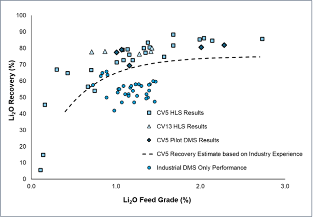
Figure 40: Metallurgical testwork results of global lithium recoveries for HLS (for the CV5 and CV13 pegmatites) as well as DMS for the CV5 Pegmatite. The estimated recovery of a three-size range DMS concentrator is shown as a recovery curve (generating a 5.5 % Li2O concentrate).
Qualified/Competent Person
The information in this news release that relates the Mineral Resource Estimate for the Shaakichiuwaanaan Project (CV5 and CV13 spodumene pegmatites), as well as other relevant technical information for the Property, is based on, and fairly represents, information compiled by Mr. Todd McCracken, P.Geo., who is a Qualified Person as defined by NI 43-101, and member in good standing with the Ordre des Géologues du Québec and with the Professional Geoscientists of Ontario. Mr. McCracken has reviewed and approved the technical information in this news release.
Mr. McCracken is Director – Mining & Geology – Central Canada, of BBA Engineering Ltd. and is independent of the Company. Mr. McCracken does not hold any securities in the Company.
Mr. McCracken has sufficient experience, which is relevant to the style of mineralization, type of deposit under consideration, and to the activities being undertaken to qualify as a Competent Person as described by the JORC Code, 2012. Mr. McCracken consents to the inclusion in this news release of the matters based on his information in the form and context in which it appears.
Table 4: Attributes for drill holes and channels included in the Shaakichiuwaanaan MRE (CV5).
| Hole ID | Hole Type | Substrate | Total Depth (m) |
Azimuth (°) |
Dip (°) |
Easting | Northing | Elevation (m) |
Core Size | Area |
| CF21-001 | DD | Land | 229.1 | 340 | -45 | 570312.0 | 5930632.4 | 382.9 | NQ | CV5 |
| CF21-002 | DD | Land | 274.2 | 340 | -45 | 570417.4 | 5930652.0 | 382.9 | NQ | CV5 |
| CF21-003 | DD | Land | 106.1 | 160 | -45 | 570284.8 | 5930718.2 | 377.5 | NQ | CV5 |
| CF21-004 | DD | Land | 148.3 | 340 | -45 | 569797.9 | 5930446.4 | 379.7 | NQ | CV5 |
| CV22-015 | DD | Ice | 176.9 | 158 | -45 | 570514.7 | 5930803.9 | 372.8 | NQ | CV5 |
| CV22-016 | DD | Ice | 252.1 | 158 | -45 | 570476.4 | 5930897.7 | 372.9 | NQ | CV5 |
| CV22-017 | DD | Ice | 344.7 | 158 | -45 | 571422.5 | 5931224.6 | 372.9 | NQ | CV5 |
| CV22-018 | DD | Ice | 149.9 | 158 | -45 | 570604.1 | 5930841.2 | 372.9 | NQ | CV5 |
| CV22-019 | DD | Ice | 230.9 | 158 | -45 | 570573.7 | 5930929.8 | 373.0 | NQ | CV5 |
| CV22-020 | DD | Ice | 203.8 | 338 | -45 | 571532.0 | 5931099.6 | 372.9 | NQ | CV5 |
| CV22-021 | DD | Ice | 246.0 | 158 | -45 | 571533.1 | 5931095.7 | 372.9 | NQ | CV5 |
| CV22-022 | DD | Ice | 184.0 | 158 | -45 | 570695.2 | 5930878.2 | 372.9 | NQ | CV5 |
| CV22-023 | DD | Ice | 285.0 | 338 | -45 | 571202.6 | 5930974.2 | 372.8 | NQ | CV5 |
| CV22-024 | DD | Ice | 156.0 | 158 | -45 | 570791.5 | 5930912.6 | 372.7 | NQ | CV5 |
| CV22-025 | DD | Ice | 153.0 | 158 | -45 | 570883.9 | 5930953.5 | 372.8 | NQ | CV5 |
| CV22-026 | DD | Ice | 156.0 | 0 | -90 | 571203.1 | 5930973.7 | 372.8 | NQ | CV5 |
| CV22-027 | DD | Ice | 150.1 | 158 | -45 | 570976.2 | 5930991.9 | 372.8 | NQ | CV5 |
| CV22-028 | DD | Ice | 291.0 | 158 | -45 | 570940.9 | 5931083.5 | 372.9 | NQ | CV5 |
| CV22-029 | DD | Ice | 165.0 | 158 | -45 | 571068.2 | 5931036.9 | 372.6 | NQ | CV5 |
| CV22-030 | DD | Ice | 258.0 | 158 | -45 | 570385.1 | 5930855.6 | 372.8 | NQ | CV5 |
| CV22-031 | DD | Ice | 231.0 | 158 | -45 | 570849.7 | 5931043.2 | 372.7 | NQ | CV5 |
| CV22-032 | DD | Land | 120.6 | 158 | -45 | 570138.4 | 5930800.9 | 380.6 | NQ | CV5 |
| CV22-033 | DD | Land | 261.1 | 158 | -45 | 571349.6 | 5931146.9 | 376.3 | NQ | CV5 |
| CV22-034 | DD | Land | 329.8 | 158 | -55 | 570138.4 | 5930801.6 | 380.8 | NQ | CV5 |
| CV22-035 | DD | Land | 281.0 | 158 | -45 | 571233.8 | 5931157.5 | 378.2 | NQ | CV5 |
| CV22-036 | DD | Land | 334.8 | 158 | -45 | 570041.9 | 5930778.2 | 379.9 | NQ | CV5 |
| CV22-037 | DD | Land | 311.0 | 158 | -45 | 571441.5 | 5931177.6 | 377.3 | NQ | CV5 |
| CV22-038 | DD | Land | 316.8 | 158 | -45 | 569940.4 | 5930729.6 | 377.1 | NQ | CV5 |
| CV22-039 | DD | Land | 256.9 | 158 | -45 | 571398.5 | 5931163.6 | 377.0 | NQ | CV5 |
| CV22-040 | DD | Land | 403.8 | 158 | -45 | 569853.1 | 5930698.0 | 375.6 | NQ | CV5 |
| CV22-041 | DD | Land | 295.9 | 158 | -45 | 571487.3 | 5931201.3 | 379.2 | NQ | CV5 |
| CV22-042 | DD | Land | 393.0 | 158 | -65 | 571487.1 | 5931201.7 | 379.1 | NQ | CV5 |
| CV22-043 | DD | Land | 513.6 | 158 | -59 | 569853.0 | 5930698.2 | 375.5 | NQ | CV5 |
| CV22-044 | DD | Land | 414.5 | 158 | -45 | 571378.4 | 5931326.0 | 379.1 | NQ | CV5 |
| CV22-045 | DD | Land | 377.4 | 158 | -45 | 569764.1 | 5930673.7 | 377.3 | NQ | CV5 |
| CV22-046 | DD | Land | 463.9 | 158 | -50 | 570343.7 | 5930959.1 | 383.3 | NQ | CV5 |
| CV22-047 | DD | Land | 554.1 | 158 | -59 | 571378.5 | 5931326.2 | 378.9 | NQ | CV5 |
| CV22-048 | DD | Land | 449.2 | 158 | -45 | 570257.0 | 5930903.3 | 381.1 | NQ | CV5 |
| CV22-049 | DD | Land | 304.8 | 158 | -45 | 571132.3 | 5931145.9 | 376.5 | NQ | CV5 |
| CV22-050 | DD | Land | 339.0 | 158 | -60 | 571132.6 | 5931146.4 | 376.4 | NQ | CV5 |
| CV22-051 | DD | Land | 520.8 | 158 | -58 | 570158.5 | 5930876.4 | 382.2 | NQ | CV5 |
| CV22-052 | DD | Land | 284.8 | 158 | -45 | 571042.1 | 5931111.4 | 375.5 | NQ | CV5 |
| CV22-053 | DD | Water | 218.5 | 158 | -45 | 570756.9 | 5930998.2 | 373.1 | NQ | CV5 |
| CV22-054 | DD | Land | 126.4 | 158 | -58 | 570014.4 | 5930567.1 | 378.9 | NQ | CV5 |
| CV22-055 | DD | Land | 320.0 | 158 | -60 | 571042.1 | 5931111.7 | 375.5 | NQ | CV5 |
| CV22-056 | DD | Water | 241.9 | 158 | -45 | 570678.6 | 5930970.9 | 373.3 | NQ | CV5 |
| CV22-057 | DD | Land | 443.1 | 158 | -45 | 570014.4 | 5930566.9 | 379.0 | NQ | CV5 |
| CV22-058 | DD | Land | 299.0 | 158 | -45 | 571169.8 | 5931057.3 | 376.4 | NQ | CV5 |
| CV22-059 | DD | Water | 352.9 | 158 | -45 | 570300.2 | 5930796.4 | 373.2 | NQ | CV5 |
| CV22-060 | DD | Land | 147.1 | 158 | -45 | 570148.9 | 5930635.1 | 383.4 | NQ | CV5 |
| CV22-061 | DD | Land | 340.9 | 158 | -45 | 571279.4 | 5931068.3 | 378.9 | NQ | CV5 |
| CV22-062 | DD | Land | 220.8 | 158 | -45 | 570233.0 | 5930693.9 | 375.8 | NQ | CV5 |
| CV22-063 | DD | Land | 325.4 | 158 | -45 | 571580.8 | 5931234.3 | 376.5 | NQ | CV5 |
| CV22-064 | DD | Water | 340.7 | 158 | -53 | 570199.3 | 5930782.3 | 373.2 | NQ | CV5 |
| CV22-065 | DD | Land | 242.0 | 158 | -45 | 570331.7 | 5930722.3 | 381.7 | NQ | CV5 |
| CV22-066 | DD | Land | 437.0 | 158 | -48 | 571560.9 | 5931295.4 | 377.0 | NQ | CV5 |
| CV22-067 | DD | Land | 281.1 | 158 | -45 | 570430.5 | 5930741.1 | 380.0 | NQ | CV5 |
| CV22-068 | DD | Land | 233.0 | 158 | -45 | 569930.0 | 5930522.4 | 378.2 | NQ | CV5 |
| CV22-069 | DD | Land | 494.1 | 158 | -65 | 571560.6 | 5931295.6 | 377.0 | NQ | CV5 |
| CV22-070 | DD | Water | 297.4 | 158 | -45 | 570118.7 | 5930731.4 | 373.2 | NQ | CV5 |
| CV22-071 | DD | Land | 377.0 | 158 | -45 | 569827.9 | 5930505.3 | 377.5 | NQ | CV5 |
| CV22-072 | DD | Water | 404.0 | 158 | -45 | 570080.9 | 5930689.0 | 373.2 | NQ | CV5 |
| CV22-073 | DD | Land | 541.9 | 158 | -52 | 571274.6 | 5931307.1 | 381.4 | NQ | CV5 |
| CV22-074 | DD | Land | 398.0 | 158 | -45 | 569719.7 | 5930500.1 | 385.9 | NQ | CV5 |
| CV22-075 | DD | Water | 372.4 | 158 | -45 | 569987.6 | 5930639.4 | 373.7 | NQ | CV5 |
| CV22-076 | DD | Land | 161.0 | 158 | -45 | 571349.0 | 5930872.5 | 377.7 | NQ | CV5 |
| CV22-078 | DD | Land | 163.8 | 158 | -65 | 571348.8 | 5930872.4 | 377.4 | NQ | CV5 |
| CV22-079 | DD | Land | 425.0 | 158 | -45 | 571661.1 | 5931296.1 | 379.5 | NQ | CV5 |
| CV22-080 | DD | Water | 359.0 | 158 | -45 | 569929.5 | 5930618.7 | 374.3 | NQ | CV5 |
| CV22-083 | DD | Land | 440.0 | 158 | -65 | 571660.9 | 5931296.4 | 379.5 | NQ | CV5 |
| CV22-086 | DD | Water | 200.0 | 158 | -45 | 571400.8 | 5931070.6 | 373.6 | NQ | CV5 |
| CV22-087 | DD | Land | 461.0 | 158 | -45 | 571192.0 | 5931275.1 | 380.1 | NQ | CV5 |
| CV22-089 | DD | Water | 251.0 | 158 | -45 | 571636.1 | 5931142.4 | 373.1 | NQ | CV5 |
| CV22-090 | DD | Land | 416.0 | 158 | -45 | 571743.8 | 5931362.1 | 378.3 | NQ | CV5 |
| CV22-093 | DD | Land | 408.2 | 158 | -65 | 571743.5 | 5931362.3 | 378.3 | NQ | CV5 |
| CV22-094 | DD | Land | 320.0 | 158 | -45 | 571087.1 | 5931259.2 | 382.9 | NQ | CV5 |
| CV22-097 | DD | Land | 506.1 | 158 | -72 | 571644.7 | 5931342.7 | 378.5 | NQ | CV5 |
| CV22-098 | DD | Land | 374.0 | 158 | -45 | 570791.5 | 5931143.5 | 380.7 | NQ | CV5 |
| CV22-100 | DD | Land | 458.0 | 158 | -45 | 571472.6 | 5931356.6 | 376.6 | NQ | CV5 |
| CV22-102 | DD | Land | 393.2 | 158 | -45 | 570626.6 | 5931060.4 | 378.5 | NQ | CV5 |
| CV23-105 | DD | Land | 452.0 | 158 | -65 | 571832.1 | 5931386.7 | 376.5 | NQ | CV5 |
| CV23-106 | DD | Land | 491.0 | 158 | -65 | 571929.5 | 5931439.0 | 377.8 | NQ | CV5 |
| CV23-107 | DD | Land | 428.2 | 158 | -65 | 572027.0 | 5931475.3 | 374.5 | NQ | CV5 |
| CV23-108 | DD | Land | 461.0 | 158 | -65 | 572118.4 | 5931506.1 | 374.0 | NQ | CV5 |
| CV23-109 | DD | Land | 392.1 | 158 | -45 | 571832.3 | 5931386.2 | 376.5 | NQ | CV5 |
| CV23-110 | DD | Land | 431.0 | 158 | -45 | 571866.1 | 5931434.5 | 375.7 | NQ | CV5 |
| CV23-111 | DD | Land | 356.0 | 158 | -45 | 572027.2 | 5931474.7 | 374.4 | NQ | CV5 |
| CV23-112 | DD | Land | 377.1 | 158 | -45 | 571929.7 | 5931438.5 | 377.8 | NQ | CV5 |
| CV23-113 | DD | Land | 389.0 | 158 | -45 | 572118.5 | 5931505.7 | 374.2 | NQ | CV5 |
| CV23-114 | DD | Land | 500.1 | 158 | -55 | 571865.9 | 5931434.7 | 375.7 | NQ | CV5 |
| CV23-115 | DD | Land | 431.1 | 158 | -45 | 572056.8 | 5931529.0 | 373.0 | NQ | CV5 |
| CV23-116 | DD | Land | 476.0 | 158 | -65 | 572214.5 | 5931532.1 | 373.5 | NQ | CV5 |
| CV23-117 | DD | Land | 566.1 | 158 | -75 | 571865.9 | 5931434.7 | 375.7 | NQ | CV5 |
| CV23-118 | DD | Land | 437.1 | 158 | -45 | 572214.8 | 5931531.4 | 373.4 | NQ | CV5 |
| CV23-119 | DD | Land | 389.0 | 158 | -45 | 572099.4 | 5931442.2 | 373.8 | NQ | CV5 |
| CV23-120 | DD | Land | 443.0 | 158 | -45 | 572150.2 | 5931552.7 | 376.5 | NQ | CV5 |
| CV23-121 | DD | Land | 454.7 | 158 | -48 | 571782.1 | 5931402.9 | 377.0 | NQ | CV5 |
| CV23-122 | DD | Land | 403.9 | 158 | -45 | 572167.6 | 5931496.0 | 375.3 | NQ | CV5 |
| CV23-123 | DD | Land | 386.0 | 158 | -45 | 571997.7 | 5931407.9 | 374.2 | NQ | CV5 |
| CV23-124 | DD | Land | 653.0 | 158 | -45 | 571955.3 | 5931497.9 | 374.4 | NQ | CV5 |
| CV23-125 | DD | Land | 545.0 | 158 | -65 | 572647.7 | 5931670.5 | 382.4 | NQ | CV5 |
| CV23-126 | DD | Land | 83.1 | 158 | -47 | 571680.9 | 5931383.6 | 375.3 | NQ | CV5 |
| CV23-127 | DD | Land | 548.0 | 158 | -59 | 571680.9 | 5931383.8 | 375.3 | NQ | CV5 |
| CV23-128 | DD | Land | 362.0 | 158 | -45 | 571212.0 | 5931077.7 | 376.5 | NQ | CV5 |
| CV23-129 | DD | Land | 380.0 | 158 | -45 | 571100.3 | 5931096.5 | 375.6 | NQ | CV5 |
| CV23-130 | DD | Land | 377.0 | 158 | -45 | 571171.8 | 5931167.6 | 374.9 | NQ | CV5 |
| CV23-131 | DD | Ice | 454.9 | 158 | -45 | 571907.3 | 5931366.9 | 373.2 | NQ | CV5 |
| CV23-132 | DD | Land | 374.0 | 158 | -49 | 571068.0 | 5931148.3 | 374.7 | NQ | CV5 |
| CV23-133 | DD | Land | 604.8 | 220 | -45 | 572646.6 | 5931668.7 | 382.6 | NQ | CV5 |
| CV23-134 | DD | Land | 331.0 | 158 | -45 | 571281.9 | 5931163.8 | 379.2 | NQ | CV5 |
| CV23-135 | DD | Land | 360.6 | 158 | -60 | 571171.6 | 5931167.9 | 374.9 | NQ | CV5 |
| CV23-136 | DD | Ice | 403.9 | 158 | -45 | 572240.8 | 5931603.3 | 373.1 | NQ | CV5 |
| CV23-137 | DD | Land | 389.0 | 158 | -65 | 571067.9 | 5931148.6 | 374.7 | NQ | CV5 |
| CV23-138 | DD | Land | 359.1 | 158 | -60 | 571281.9 | 5931163.8 | 379.2 | NQ | CV5 |
| CV23-139 | DD | Ice | 565.9 | 158 | -65 | 572396.1 | 5931617.8 | 372.9 | NQ | CV5 |
| CV23-140 | DD | Ice | 545.3 | 158 | -65 | 572306.4 | 5931573.2 | 373.0 | NQ | CV5 |
| CV23-141 | DD | Land | 400.9 | 158 | -60 | 571781.4 | 5931403.7 | 377.9 | NQ | CV5 |
| CV23-142 | DD | Land | 359.0 | 158 | -73 | 571387.3 | 5931180.7 | 377.2 | NQ | CV5 |
| CV23-143 | DD | Land | 530.2 | 158 | -45 | 572647.9 | 5931670.0 | 382.4 | NQ | CV5 |
| CV23-144 | DD | Land | 25.7 | 0 | -90 | 570316.3 | 5930295.9 | 380.0 | HQ | CV5 |
| CV23-145 | DD | Land | 53.0 | 0 | -90 | 569657.7 | 5930878.2 | 372.7 | HQ | CV5 |
| CV23-146 | DD | Ice | 416.0 | 158 | -45 | 572306.4 | 5931573.2 | 373.0 | NQ | CV5 |
| CV23-147 | DD | Land | 185.0 | 0 | -90 | 571121.4 | 5931096.9 | 376.0 | NQ | CV5 |
| CV23-148 | DD | Land | 332.0 | 158 | -58 | 571387.4 | 5931180.3 | 377.3 | NQ | CV5 |
| CV23-150 | DD | Land | 302.1 | 0 | -90 | 571426.9 | 5931160.9 | 376.7 | NQ | CV5 |
| CV23-151 | DD | Ice | 486.0 | 158 | -45 | 572396.1 | 5931617.8 | 372.9 | NQ | CV5 |
| CV23-152 | DD | Land | 398.0 | 158 | -47 | 570714.1 | 5931114.0 | 378.8 | NQ | CV5 |
| CV23-153 | DD | Land | 300.1 | 0 | -90 | 571785.2 | 5931397.3 | 378.6 | NQ | CV5 |
| CV23-154 | DD | Ice | 574.9 | 158 | -65 | 572487.3 | 5931652.3 | 372.9 | NQ | CV5 |
| CV23-155 | DD | Land | 24.9 | 0 | -90 | 571686.6 | 5930748.6 | 379.8 | HQ | CV5 |
| CV23-156 | DD | Land | 581.3 | 176 | -67 | 572647.4 | 5931670.4 | 382.6 | NQ | CV5 |
| CV23-157 | DD | Land | 278.1 | 0 | -90 | 570694.6 | 5931128.2 | 379.0 | NQ | CV5 |
| CV23-159 | DD | Land | 50.0 | 0 | -90 | 570520.0 | 5931135.3 | 375.6 | HQ | CV5 |
| CV23-160A | DD | Land | 443.0 | 158 | -45 | 569567.5 | 5930470.9 | 380.4 | NQ | CV5 |
| CV23-161 | DD | Land | 360.0 | 158 | -45 | 569627.6 | 5930449.9 | 384.8 | NQ | CV5 |
| CV23-162 | DD | Ice | 482.0 | 158 | -45 | 572487.3 | 5931652.3 | 372.9 | NQ | CV5 |
| CV23-164 | DD | Land | 200.0 | 0 | -90 | 570020.1 | 5930773.5 | 378.1 | NQ | CV5 |
| CV23-165 | DD | Land | 555.1 | 165 | -60 | 572647.7 | 5931669.8 | 382.4 | NQ | CV5 |
| CV23-166A | DD | Land | 50.0 | 0 | -90 | 569353.0 | 5930256.3 | 389.1 | HQ | CV5 |
| CV23-167 | DD | Land | 25.5 | 0 | -90 | 572024.6 | 5931654.1 | 374.9 | HQ | CV5 |
| CV23-168A | DD | Ice | 388.1 | 158 | -47 | 571515.8 | 5931250.9 | 373.0 | NQ | CV5 |
| CV23-169 | DD | Land | 302.0 | 0 | -90 | 569733.9 | 5930466.5 | 379.2 | NQ | CV5 |
| CV23-170 | DD | Ice | 431.6 | 158 | -45 | 572461.9 | 5931596.5 | 373.0 | NQ | CV5 |
| CV23-171 | DD | Land | 373.4 | 158 | -63 | 569568.8 | 5930470.2 | 380.1 | NQ | CV5 |
| CV23-172 | DD | Land | 404.0 | 158 | -45 | 569479.9 | 5930448.2 | 384.1 | NQ | CV5 |
| CV23-173 | DD | Ice | 516.7 | 158 | -65 | 572461.9 | 5931596.5 | 373.0 | NQ | CV5 |
| CV23-174 | DD | Land | 421.7 | 0 | -90 | 569992.0 | 5930469.4 | 381.0 | NQ | CV5 |
| CV23-175 | DD | Ice | 458.0 | 158 | -57 | 571316.1 | 5931230.2 | 372.9 | NQ | CV5 |
| CV23-176 | DD | Land | 434.0 | 158 | -45 | 569388.0 | 5930399.5 | 386.2 | NQ | CV5 |
| CV23-177 | DD | Ice | 394.7 | 158 | -45 | 571453.4 | 5931292.5 | 373.0 | NQ | CV5 |
| CV23-178 | DD | Land | 473.2 | 158 | -62 | 569479.8 | 5930448.6 | 384.1 | NQ | CV5 |
| CV23-179 | DD | Ice | 437.0 | 158 | -45 | 572368.8 | 5931547.6 | 372.9 | NQ | CV5 |
| CV23-180 | DD | Land | 379.6 | 158 | -60 | 569387.8 | 5930400.0 | 386.2 | NQ | CV5 |
| CV23-181 | DD | Ice | 354.0 | 158 | -46 | 571316.2 | 5931230.0 | 372.9 | NQ | CV5 |
| CV23-182 | DD | Land | 369.0 | 158 | -45 | 569295.1 | 5930361.6 | 389.4 | NQ | CV5 |
| CV23-183 | DD | Ice | 477.1 | 158 | -65 | 572368.7 | 5931548.1 | 372.8 | NQ | CV5 |
| CV23-184 | DD | Land | 417.4 | 158 | -45 | 569198.6 | 5930332.0 | 392.7 | NQ | CV5 |
| CV23-185 | DD | Ice | 425.0 | 158 | -60 | 571453.3 | 5931292.7 | 372.9 | NQ | CV5 |
| CV23-186 | DD | Land | 49.6 | 0 | -90 | 572596.5 | 5931710.3 | 374.2 | HQ | CV5 |
| CV23-187 | DD | Land | 287.0 | 158 | -45 | 569698.8 | 5930420.6 | 381.0 | NQ | CV5 |
| CV23-188 | DD | Land | 362.0 | 158 | -60 | 569294.9 | 5930361.9 | 389.3 | NQ | CV5 |
| CV23-189 | DD | Land | 287.0 | 158 | -45 | 571702.0 | 5931318.4 | 380.1 | NQ | CV5 |
| CV23-190 | DD | Land | 303.3 | 338 | -45 | 569596.9 | 5930277.1 | 382.2 | NQ | CV5 |
| CV23-192 | DD | Land | 354.0 | 0 | -90 | 570330.5 | 5930613.3 | 383.4 | NQ | CV5 |
| CV23-193 | DD | Land | 250.9 | 0 | -90 | 569597.2 | 5930276.2 | 381.2 | NQ | CV5 |
| CV23-194 | DD | Land | 282.0 | 0 | -90 | 570802.4 | 5930731.5 | 382.1 | NQ | CV5 |
| CV23-196 | DD | Land | 263.0 | 158 | -45 | 569599.0 | 5930272.7 | 381.3 | NQ | CV5 |
| CV23-197 | DD | Land | 254.0 | 158 | -45 | 570803.1 | 5930728.3 | 382.0 | NQ | CV5 |
| CV23-199 | DD | Land | 261.1 | 0 | -90 | 570473.2 | 5930744.8 | 376.9 | NQ | CV5 |
| CV23-201 | DD | Land | 385.8 | 158 | -45 | 569015.1 | 5930242.6 | 390.3 | NQ | CV5 |
| CV23-203 | DD | Land | 374.0 | 158 | -45 | 569121.0 | 5930244.3 | 396.1 | NQ | CV5 |
| CV23-205 | DD | Land | 353.0 | 158 | -60 | 569015.0 | 5930242.8 | 390.2 | NQ | CV5 |
| CV23-206 | DD | Land | 322.8 | 158 | -60 | 569120.8 | 5930244.6 | 396.1 | NQ | CV5 |
| CV23-208 | DD | Land | 368.0 | 158 | -45 | 568937.2 | 5930165.2 | 391.0 | NQ | CV5 |
| CV23-209 | DD | Land | 434.0 | 158 | -45 | 569043.4 | 5930314.1 | 384.9 | NQ | CV5 |
| CV23-211 | DD | Land | 425.0 | 158 | -60 | 568937.1 | 5930165.5 | 391.0 | NQ | CV5 |
| CV23-212 | DD | Water | 296.0 | 158 | -45 | 571736.6 | 5931251.3 | 372.7 | NQ | CV5 |
| CV23-214 | DD | Land | 502.1 | 158 | -55 | 569043.3 | 5930314.3 | 384.7 | NQ | CV5 |
| CV23-217 | DD | Land | 329.0 | 158 | -45 | 568751.3 | 5930093.9 | 390.0 | NQ | CV5 |
| CV23-219 | DD | Land | 380.1 | 158 | -45 | 568848.3 | 5930136.9 | 394.8 | NQ | CV5 |
| CV23-220 | DD | Water | 275.0 | 158 | -45 | 571824.6 | 5931284.7 | 372.2 | NQ | CV5 |
| CV23-222 | DD | Land | 404.0 | 158 | -65 | 568751.1 | 5930094.6 | 390.1 | NQ | CV5 |
| CV23-223 | DD | Land | 428.0 | 158 | -60 | 568848.3 | 5930137.2 | 394.9 | NQ | CV5 |
| CV23-225 | DD | Water | 452.0 | 158 | -45 | 571936.0 | 5931267.6 | 372.2 | NQ | CV5 |
| CV23-226 | DD | Land | 338.0 | 158 | -45 | 568706.3 | 5930070.7 | 386.7 | NQ | CV5 |
| CV23-228 | DD | Land | 510.0 | 158 | -80 | 568847.6 | 5930136.7 | 394.7 | NQ | CV5 |
| CV23-230 | DD | Water | 311.0 | 158 | -45 | 570172.3 | 5930717.7 | 372.7 | NQ | CV5 |
| CV23-231 | DD | Land | 359.0 | 158 | -65 | 568706.0 | 5930071.1 | 386.6 | NQ | CV5 |
| CV23-232 | DD | Water | 388.9 | 158 | -45 | 572029.7 | 5931311.9 | 373.4 | NQ | CV5 |
| CV23-236 | DD | Land | 383.1 | 158 | -45 | 568615.9 | 5930016.6 | 387.6 | NQ | CV5 |
| CV23-240 | DD | Land | 377.0 | 158 | -45 | 568637.2 | 5930099.9 | 391.5 | NQ | CV5 |
| CV23-241 | DD | Water | 418.9 | 158 | -62 | 570172.4 | 5930717.8 | 372.6 | NQ | CV5 |
| CV23-243 | DD | Land | 395.0 | 158 | -65 | 568615.8 | 5930017.1 | 387.4 | NQ | CV5 |
| CV23-244 | DD | Water | 313.0 | 158 | -45 | 572125.2 | 5931345.5 | 372.9 | NQ | CV5 |
| CV23-246 | DD | Land | 431.0 | 0 | -90 | 570215.1 | 5930649.7 | 382.3 | NQ | CV5 |
| CV23-248 | DD | Land | 466.1 | 158 | -65 | 568636.9 | 5930100.4 | 391.6 | NQ | CV5 |
| CV23-251 | DD | Water | 160.9 | 158 | -45 | 570938.7 | 5930950.0 | 373.2 | NQ | CV5 |
| CV23-252 | DD | Water | 281.0 | 158 | -45 | 572214.3 | 5931370.1 | 372.2 | NQ | CV5 |
| CV23-256 | DD | Water | 296.2 | 158 | -45 | 571043.3 | 5930964.1 | 372.1 | NQ | CV5 |
| CV23-259 | DD | Land | 383.0 | 158 | -45 | 568550.1 | 5930065.0 | 393.5 | NQ | CV5 |
| CV23-260 | DD | Water | 260.0 | 158 | -45 | 572336.8 | 5931379.7 | 372.1 | NQ | CV5 |
| CV23-262 | DD | Land | 245.1 | 0 | -90 | 571313.5 | 5930901.0 | 377.6 | NQ | CV5 |
| CV23-265 | DD | Water | 277.9 | 158 | -45 | 571134.0 | 5931003.5 | 372.3 | NQ | CV5 |
| CV23-268 | DD | Land | 417.6 | 158 | -65 | 568550.3 | 5930064.6 | 393.4 | NQ | CV5 |
| CV23-272A | DD | Water | 410.2 | 158 | -45 | 570328.8 | 5930856.6 | 372.8 | NQ | CV5 |
| CV23-273 | DD | Land | 359.0 | 158 | -45 | 568457.9 | 5930020.1 | 392.5 | NQ | CV5 |
| CV23-274 | DD | Water | 226.4 | 158 | -45 | 571199.9 | 5930974.4 | 372.6 | NQ | CV5 |
| CV23-279 | DD | Water | 227.7 | 158 | -45 | 571250.2 | 5930988.5 | 373.1 | NQ | CV5 |
| CV23-283 | DD | Land | 362.0 | 158 | -45 | 568526.0 | 5929989.7 | 387.7 | NQ | CV5 |
| CV23-285 | DD | Water | 469.9 | 158 | -60 | 570328.4 | 5930856.8 | 372.8 | NQ | CV5 |
| CV23-287 | DD | Water | 176.0 | 158 | -45 | 571336.6 | 5931031.0 | 372.8 | NQ | CV5 |
| CV23-290 | DD | Land | 443.0 | 158 | -60 | 569197.2 | 5930336.0 | 392.0 | NQ | CV5 |
| CV23-291 | DD | Water | 169.2 | 158 | -70 | 571336.7 | 5931031.4 | 372.3 | NQ | CV5 |
| CV23-292 | DD | Land | 389.1 | 158 | -65 | 568457.4 | 5930020.9 | 392.5 | NQ | CV5 |
| CV23-295 | DD | Land | 362.9 | 158 | -65 | 568526.0 | 5929990.0 | 387.7 | NQ | CV5 |
| CV23-297 | DD | Water | 194.0 | 158 | -45 | 571682.5 | 5931113.0 | 372.5 | NQ | CV5 |
| CV23-298 | DD | Water | 440.1 | 158 | -64 | 570449.3 | 5930831.3 | 372.7 | NQ | CV5 |
| CV23-303 | DD | Land | 290.9 | 158 | -45 | 568922.1 | 5930064.4 | 395.4 | NQ | CV5 |
| CV23-307 | DD | Land | 357.3 | 285 | -45 | 569814.2 | 5930403.6 | 382.3 | NQ | CV5 |
| CV23-308 | DD | Water | 171.2 | 158 | -46 | 571479.7 | 5931087.4 | 372.9 | NQ | CV5 |
| CV23-313 | DD | Water | 371.0 | 158 | -45 | 570449.7 | 5930830.8 | 372.7 | NQ | CV5 |
| CV23-314 | DD | Water | 359.0 | 338 | -45 | 571479.2 | 5931088.9 | 372.1 | NQ | CV5 |
| CV23-317 | DD | Land | 431.9 | 338 | -45 | 568922.9 | 5930067.3 | 395.1 | NQ | CV5 |
| CV23-321 | DD | Land | 252.1 | 158 | -45 | 569813.6 | 5930404.2 | 381.9 | NQ | CV5 |
| CV23-325 | DD | Water | 238.9 | 158 | -47 | 571440.8 | 5931045.2 | 372.2 | NQ | CV5 |
| CV23-327 | DD | Water | 386.0 | 158 | -45 | 570541.7 | 5930871.4 | 372.7 | NQ | CV5 |
| CV23-329 | DD | Land | 277.8 | 310 | -55 | 569812.8 | 5930405.2 | 381.9 | NQ | CV5 |
| CV23-331 | DD | Land | 423.0 | 158 | -45 | 568415.4 | 5929988.0 | 395.9 | NQ | CV5 |
| CV23-334 | DD | Land | 70.4 | 338 | -45 | 569813.6 | 5930403.6 | 381.9 | NQ | CV5 |
| CV23-335 | DD | Water | 263.0 | 158 | -76 | 571440.5 | 5931063.1 | 372.7 | NQ | CV5 |
| CV23-337 | DD | Land | 427.9 | 338 | -45 | 569717.2 | 5930368.0 | 382.0 | NQ | CV5 |
| CV23-338 | DD | Water | 176.0 | 158 | -45 | 570761.8 | 5930850.3 | 372.9 | NQ | CV5 |
| CV23-340 | DD | Water | 212.0 | 158 | -60 | 571760.9 | 5931197.6 | 372.9 | NQ | CV5 |
| CV23-342 | DD | Water | 212.0 | 158 | -45 | 570631.7 | 5930908.8 | 372.8 | NQ | CV5 |
| CV23-344 | DD | Land | 530.2 | 158 | -65 | 568415.3 | 5929988.4 | 395.9 | NQ | CV5 |
| CV23-347 | DD | Land | 230.0 | 158 | -45 | 569717.7 | 5930367.4 | 382.0 | NQ | CV5 |
| CV23-349 | DD | Water | 133.9 | 158 | -45 | 571865.8 | 5931191.5 | 373.4 | NQ | CV5 |
| CV23-352 | DD | Land | 227.0 | 158 | -45 | 569626.0 | 5930335.2 | 381.7 | NQ | CV5 |
| CV23-354 | DD | Land | 296.0 | 158 | -45 | 569536.2 | 5930296.9 | 381.9 | NQ | CV5 |
| CV23-357 | DD | Land | 328.8 | 158 | -45 | 568371.0 | 5929961.8 | 392.7 | NQ | CV5 |
| CV23-359 | DD | Land | 251.1 | 158 | -45 | 569443.3 | 5930256.2 | 383.8 | NQ | CV5 |
| CV23-362 | DD | Land | 356.1 | 338 | -45 | 571560.3 | 5931009.3 | 373.3 | NQ | CV5 |
| CV23-363 | DD | Land | 218.0 | 158 | -45 | 569347.1 | 5930221.6 | 389.4 | NQ | CV5 |
| CV23-364 | DD | Land | 401.0 | 158 | -65 | 568370.8 | 5929962.2 | 392.6 | NQ | CV5 |
| CV24-366 | DD | Land | 489.4 | 158 | -52 | 570954.3 | 5931181.8 | 376.3 | NQ | CV5 |
| CV24-367 | DD | Land | 459.2 | 160 | -49 | 571374.2 | 5931330.7 | 378.5 | NQ | CV5 |
| CV24-368 | DD | Land | 493.9 | 158 | -50 | 569790.2 | 5930721.4 | 375.2 | NQ | CV5 |
| CV24-369 | DD | Land | 532.7 | 158 | -62 | 570253.4 | 5930912.1 | 381.3 | NQ | CV5 |
| CV24-370 | DD | Land | 511.8 | 158 | -48 | 570073.6 | 5930820.6 | 381.2 | NQ | CV5 |
| CV24-371 | DD | Land | 561.9 | 158 | -57 | 571477.3 | 5931353.1 | 374.7 | NQ | CV5 |
| CV24-372 | DD | Land | 487.9 | 158 | -45 | 570218.9 | 5930863.1 | 375.2 | NQ | CV5 |
| CV24-373 | DD | Land | 479.2 | 160 | -45 | 569832.6 | 5930629.6 | 373.0 | NQ | CV5 |
| CV24-374 | DD | Land | 470.0 | 158 | -46 | 570693.3 | 5931027.8 | 373.3 | NQ | CV5 |
| CV24-375 | DD | Land | 302.1 | 158 | -45 | 569251.7 | 5930186.6 | 395.0 | NQ | CV5 |
| CV24-376 | DD | Land | 583.7 | 158 | -60 | 570036.0 | 5930779.8 | 377.9 | NQ | CV5 |
| CV24-377 | DD | Land | 451.9 | 158 | -45 | 569911.5 | 5930690.1 | 374.0 | NQ | CV5 |
| CV24-378 | DD | Land | 493.0 | 158 | -47 | 571569.3 | 5931385.6 | 374.0 | NQ | CV5 |
| CV24-379 | DD | Land | 613.9 | 158 | -60 | 570693.4 | 5931028.3 | 373.3 | NQ | CV5 |
| CV24-380 | DD | Land | 559.9 | 158 | -60 | 570218.9 | 5930863.3 | 374.9 | NQ | CV5 |
| CV24-381 | DD | Land | 302.1 | 158 | -45 | 569160.9 | 5930149.9 | 395.0 | NQ | CV5 |
| CV24-382 | DD | Land | 506.0 | 158 | -56 | 569911.6 | 5930690.5 | 373.9 | NQ | CV5 |
| CV24-383 | DD | Land | 166.0 | 158 | -45 | 569002.5 | 5930140.8 | 396.8 | NQ | CV5 |
| CV24-383A | DD | Land | 308.0 | 158 | -45 | 569003.7 | 5930137.6 | 396.3 | NQ | CV5 |
| CV24-384 | DD | Land | 545.9 | 158 | -57 | 569946.9 | 5930739.3 | 376.4 | NQ | CV5 |
| CV24-385 | DD | Land | 382.9 | 158 | -45 | 569148.4 | 5930308.3 | 394.3 | NQ | CV5 |
| CV24-386 | DD | Land | 552.6 | 158 | -58 | 571388.7 | 5931175.9 | 376.5 | NQ | CV5 |
| CV24-387 | DD | Land | 627.9 | 158 | -52 | 570307.0 | 5931047.4 | 377.0 | NQ | CV5 |
| CV24-388 | DD | Land | 515.0 | 158 | -58 | 571569.1 | 5931386.1 | 374.1 | NQ | CV5 |
| CV24-389 | DD | Land | 388.2 | 158 | -45 | 569443.3 | 5930367.7 | 383.5 | NQ | CV5 |
| CV24-390 | DD | Land | 620.0 | 158 | -45 | 570392.4 | 5930967.3 | 379.2 | NQ | CV5 |
| CV24-391 | DD | Land | 341.0 | 158 | -45 | 569214.2 | 5930279.5 | 396.6 | NQ | CV5 |
| CV24-392 | DD | Land | 633.1 | 165 | -58 | 571841.1 | 5931393.0 | 377.3 | NQ | CV5 |
| CV24-393 | DD | Land | 462.3 | 158 | -75 | 569003.4 | 5930138.0 | 396.2 | NQ | CV5 |
| CV24-394 | DD | Land | 575.2 | 158 | -47 | 571605.9 | 5931299.3 | 377.2 | NQ | CV5 |
| CV24-395 | DD | Land | 296.1 | 158 | -45 | 569280.1 | 5930256.9 | 394.0 | NQ | CV5 |
| CV24-398 | DD | Land | 431.0 | 158 | -45 | 569409.3 | 5930473.0 | 374.9 | NQ | CV5 |
| CV24-399 | DD | Ice | 527.0 | 158 | -60 | 570600.6 | 5930984.8 | 372.1 | NQ | CV5 |
| CV24-400 | DD | Land | 551.0 | 158 | -52 | 571388.7 | 5931175.6 | 376.5 | NQ | CV5 |
| CV24-401 | DD | Land | 280.9 | 158 | -58 | 572052.4 | 5931534.8 | 373.7 | NQ | CV5 |
| CV24-401A | DD | Land | 626.1 | 158 | -58 | 572056.2 | 5931528.9 | 373.1 | NQ | CV5 |
| CV24-402 | DD | Land | 444.4 | 158 | -75 | 569280.1 | 5930257.5 | 393.9 | NQ | CV5 |
| CV24-403 | DD | Land | 373.9 | 158 | -45 | 569031.2 | 5930205.5 | 393.6 | NQ | CV5 |
| CV24-404 | DD | Land | 668.2 | 162 | -59 | 571931.0 | 5931431.7 | 377.3 | NQ | CV5 |
| CV24-405 | DD | Land | 439.9 | 158 | -60 | 571659.0 | 5931300.4 | 378.4 | NQ | CV5 |
| CV24-407 | DD | Land | 296.0 | 158 | -45 | 569066.8 | 5930115.0 | 394.7 | NQ | CV5 |
| CV24-408 | DD | Land | 410.0 | 158 | -45 | 569237.8 | 5930354.0 | 389.3 | NQ | CV5 |
| CV24-409 | DD | Land | 356.1 | 158 | -45 | 569542.0 | 5930406.0 | 383.7 | NQ | CV5 |
| CV24-410 | DD | Ice | 609.0 | 158 | -47 | 570507.2 | 5930955.1 | 372.0 | NQ | CV5 |
| CV24-413 | DD | Ice | 431.0 | 158 | -62 | 570940.7 | 5931079.8 | 372.1 | NQ | CV5 |
| CV24-414 | DD | Land | 425.0 | 158 | -45 | 569516.5 | 5930473.0 | 383.8 | NQ | CV5 |
| CV24-415 | DD | Land | 91.6 | 158 | -45 | 571679.3 | 5931388.0 | 374.3 | NQ | CV5 |
| CV24-415A | DD | Land | 576.4 | 158 | -45 | 571679.3 | 5931388.3 | 374.3 | NQ | CV5 |
| CV24-416 | DD | Land | 334.8 | 158 | -45 | 569358.6 | 5930330.1 | 389.7 | NQ | CV5 |
| CV24-418 | DD | Ice | 624.4 | 158 | -47 | 570600.7 | 5930984.1 | 372.1 | NQ | CV5 |
| CV24-419 | DD | Land | 595.9 | 165 | -45 | 572117.8 | 5931509.9 | 372.8 | NQ | CV5 |
| CV24-422 | DD | Land | 572.8 | 160 | -58 | 571955.7 | 5931504.0 | 373.3 | NQ | CV5 |
| CV24-423A | DD | Land | 329.0 | 158 | -75 | 569358.9 | 5930329.9 | 389.6 | NQ | CV5 |
| CV24-424 | DD | Land | 389.0 | 158 | -53 | 569615.3 | 5930495.5 | 378.1 | NQ | CV5 |
| CV24-426 | DD | Ice | 587.0 | 158 | -45 | 571004.5 | 5931058.8 | 371.9 | NQ | CV5 |
| CV24-428 | DD | Ice | 543.1 | 158 | -45 | 570728.4 | 5930940.4 | 372.1 | NQ | CV5 |
| CV24-430 | DD | Land | 361.9 | 158 | -45 | 569187.9 | 5930215.3 | 397.6 | NQ | CV5 |
| CV24-431 | DD | Land | 352.9 | 338 | -60 | 569800.9 | 5930431.0 | 379.5 | NQ | CV5 |
| CV24-433 | DD | Ice | 508.9 | 158 | -48 | 570881.7 | 5931098.0 | 372.1 | NQ | CV5 |
| CV24-434 | DD | Ice | 467.8 | 158 | -60 | 570507.2 | 5930955.1 | 372.0 | NQ | CV5 |
| CV24-435 | DD | Land | 502.9 | 158 | -60 | 572117.8 | 5931509.9 | 372.8 | NQ | CV5 |
| CV24-437 | DD | Land | 433.9 | 158 | -55 | 571679.2 | 5931388.7 | 374.3 | NQ | CV5 |
| CV24-438 | DD | Ice | 408.3 | 158 | -48 | 571812.0 | 5931329.7 | 372.0 | NQ | CV5 |
| CV24-440 | DD | Land | 438.5 | 158 | -75 | 569187.5 | 5930215.9 | 397.5 | NQ | CV5 |
| CV24-441 | DD | Ice | 342.2 | 158 | -65 | 571004.7 | 5931058.3 | 372.0 | NQ | CV5 |
| CV24-442 | DD | Land | 299.1 | 158 | -87 | 569802.0 | 5930429.6 | 379.4 | NQ | CV5 |
| CV24-443 | DD | Ice | 383.2 | 158 | -45 | 570818.0 | 5930984.2 | 372.0 | NQ | CV5 |
| CV24-445 | DD | Ice | 295.3 | 158 | -45 | 571968.9 | 5931339.0 | 371.9 | NQ | CV5 |
| CV24-447 | DD | Land | 308.4 | 130 | -55 | 571152.3 | 5931101.1 | 375.1 | NQ | CV5 |
| CV24-448 | DD | Land | 341.9 | 158 | -75 | 569802.0 | 5930430.0 | 379.4 | NQ | CV5 |
| CV24-449 | DD | Ice | 291.8 | 158 | -62 | 570881.7 | 5931098.3 | 372.0 | NQ | CV5 |
| CV24-450 | DD | Land | 299.0 | 160 | -45 | 569864.8 | 5930545.1 | 373.3 | NQ | CV5 |
| CV24-451 | DD | Ice | 503.0 | 158 | -45 | 571771.2 | 5931288.6 | 372.0 | NQ | CV5 |
| CV24-452 | DD | Land | 505.9 | 145 | -50 | 571679.5 | 5931388.0 | 374.3 | NQ | CV5 |
| CV24-455 | DD | Ice | 379.8 | 158 | -45 | 570909.9 | 5931018.4 | 372.0 | NQ | CV5 |
| CV24-456 | DD | Land | 456.9 | 200 | -55 | 570174.5 | 5930836.0 | 378.3 | NQ | CV5 |
| CV24-458 | DD | Ice | 328.0 | 156 | -62 | 571968.6 | 5931339.6 | 371.9 | NQ | CV5 |
| CV24-459 | DD | Land | 314.1 | 296 | -60 | 571508.9 | 5930921.8 | 374.6 | NQ | CV5 |
| CV24-460 | DD | Ice | 263.0 | 158 | -45 | 571650.2 | 5931198.3 | 372.0 | NQ | CV5 |
| CV24-462 | DD | Land | 299.5 | 158 | -45 | 569773.4 | 5930503.0 | 377.2 | NQ | CV5 |
| CV24-463 | DD | Land | 337.9 | 158 | -45 | 570612.9 | 5930686.0 | 378.8 | NQ | CV5 |
| CV24-465 | DD | Ice | 325.0 | 158 | -48 | 571877.8 | 5931300.2 | 372.1 | NQ | CV5 |
| CV24-466 | DD | Ice | 530.3 | 338 | -45 | 571841.0 | 5931124.0 | 372.0 | NQ | CV5 |
| CV24-467 | DD | Ice | 539.2 | 158 | -45 | 570782.1 | 5931075.0 | 372.3 | NQ | CV5 |
| CV24-468 | DD | Ice | 461.0 | 158 | -46 | 571695.3 | 5931217.0 | 372.0 | NQ | CV5 |
| CV24-469 | DD | Land | 409.9 | 40 | -60 | 571572.0 | 5930953.4 | 373.2 | NQ | CV5 |
| CV24-472 | DD | Land | 355.9 | 338 | -45 | 570503.6 | 5930694.8 | 379.8 | NQ | CV5 |
| CV24-473 | DD | Ice | 359.0 | 153 | -58 | 571514.3 | 5931262.1 | 371.9 | NQ | CV5 |
| CV24-474 | DD | Land | 223.9 | 159 | -46 | 569207.2 | 5930170.9 | 396.0 | NQ | CV5 |
| CV24-475 | DD | Ice | 280.1 | 158 | -45 | 572062.4 | 5931376.6 | 371.9 | NQ | CV5 |
| CV24-476 | DD | Land | 557.0 | 154 | -55 | 570170.7 | 5930834.1 | 378.4 | NQ | CV5 |
| CV24-479 | DD | Land | 467.1 | 16 | -55 | 570355.0 | 5930476.9 | 379.2 | NQ | CV5 |
| CV24-480 | DD | Land | 560.3 | 158 | -65 | 571994.4 | 5931554.1 | 372.2 | NQ | CV5 |
| CV24-481 | DD | Land | 272.3 | 157 | -46 | 569311.2 | 5930294.6 | 391.0 | NQ | CV5 |
| CV24-482 | DD | Ice | 305.0 | 158 | -55 | 572062.4 | 5931376.0 | 371.9 | NQ | CV5 |
| CV24-485 | DD | Ice | 365.0 | 150 | -45 | 571515.2 | 5931261.4 | 371.9 | NQ | CV5 |
| CV24-486 | DD | Ice | 299.0 | 156 | -45 | 571551.6 | 5931169.2 | 372.0 | NQ | CV5 |
| CV24-488 | DD | Land | 197.0 | 160 | -45 | 569373.9 | 5930278.5 | 390.3 | NQ | CV5 |
| CV24-489 | DD | Land | 356.0 | 158 | -45 | 570204.3 | 5930636.1 | 382.0 | NQ | CV5 |
| CV24-490 | DD | Ice | 314.3 | 158 | -47 | 572155.1 | 5931412.9 | 372.1 | NQ | CV5 |
| CV24-493 | DD | Land | 218.1 | 160 | -45 | 569649.4 | 5930384.4 | 381.0 | NQ | CV5 |
| CV24-494 | DD | Land | 439.9 | 158 | -60 | 570227.9 | 5930714.7 | 374.8 | NQ | CV5 |
| CV24-495 | DD | Ice | 230.3 | 158 | -45 | 571803.4 | 5931216.2 | 372.0 | NQ | CV5 |
| CV24-496 | DD | Land | 509.0 | 113 | -55 | 571529.1 | 5931440.2 | 390.7 | NQ | CV5 |
| CV24-500 | DD | Land | 512.1 | 158 | -65 | 571932.1 | 5931649.5 | 378.7 | NQ | CV5 |
| CV24-501 | DD | Land | 46.7 | 155 | -49 | 572024.8 | 5931469.7 | 377.9 | NQ | CV5 |
| CV24-501A | DD | Land | 403.2 | 155 | -49 | 572023.6 | 5931471.2 | 374.6 | NQ | CV5 |
| CV24-502 | DD | Land | 476.5 | 145 | -52 | 570360.1 | 5930766.7 | 374.0 | NQ | CV5 |
| CV24-503 | DD | Land | 533.1 | 160 | -45 | 570305.6 | 5930884.3 | 372.1 | NQ | CV5 |
| CV24-504 | DD | Land | 302.4 | 158 | -45 | 570181.3 | 5930561.3 | 385.0 | NQ | CV5 |
| CV24-505 | DD | Land | 581.0 | 158 | -58 | 569994.1 | 5930753.1 | 376.5 | NQ | CV5 |
| CV24-509 | DD | Land | 425.4 | 157 | -53 | 570262.4 | 5930743.7 | 373.9 | NQ | CV5 |
| CV24-512 | DD | Land | 317.0 | 158 | -46 | 570054.0 | 5930596.6 | 376.9 | NQ | CV5 |
| CV24-514 | DD | Land | 601.3 | 158 | -50 | 570459.7 | 5931100.8 | 378.2 | NQ | CV5 |
| CV24-515 | DD | Ice | 424.4 | 160 | -58 | 572240.8 | 5931602.7 | 371.8 | NQ | CV5 |
| CV24-516 | DD | Land | 517.9 | 170 | -45 | 572564.5 | 5931732.2 | 375.0 | NQ | CV5 |
| CV24-517 | DD | Land | 428.1 | 152 | -56 | 570402.3 | 5930773.8 | 374.1 | NQ | CV5 |
| CV24-521 | DD | Land | 504.1 | 158 | -45 | 568928.0 | 5930328.5 | 377.9 | NQ | CV5 |
| CV24-522 | DD | Land | 260.2 | 159 | -45 | 570073.4 | 5930544.4 | 379.3 | NQ | CV5 |
| CV24-526 | DD | Land | 442.9 | 158 | -45 | 569994.4 | 5930752.6 | 376.4 | NQ | CV5 |
| CV24-527 | DD | Water | 8.6 | 0 | -90 | 571468.7 | 5931004.9 | 372.8 | NQ | CV5 |
| CV24-528 | DD | Water | 108.7 | 0 | -90 | 571721.4 | 5930952.2 | 372.4 | NQ | CV5 |
| CV24-530 | DD | Water | 12.0 | 0 | -90 | 571443.6 | 5931037.8 | 373.0 | NQ | CV5 |
| CV24-531 | DD | Water | 99.4 | 0 | -90 | 572280.4 | 5931431.0 | 379.8 | NQ | CV5 |
| CV24-533 | DD | Land | 51.9 | 0 | -90 | 568982.8 | 5930569.5 | 378.5 | HQ | CV5 |
| CV24-534 | DD | Land | 56.0 | 0 | -90 | 569493.0 | 5929975.9 | 384.3 | HQ | CV5 |
| CV24-536 | DD | Land | 53.0 | 0 | -90 | 568354.6 | 5930071.6 | 397.6 | HQ | CV5 |
| CV24-537 | DD | Land | 30.6 | 0 | -90 | 570702.3 | 5931577.7 | 384.3 | HQ | North CV5 |
| CV24-541 | DD | Water | 13.1 | 0 | -90 | 571882.6 | 5931252.9 | 371.9 | NQ | CV5 |
| CV24-542 | DD | Water | 11.1 | 0 | -90 | 571235.6 | 5930959.1 | 372.9 | NQ | CV5 |
| CV24-547 | DD | Land | 10.3 | 0 | -90 | 570060.1 | 5931470.4 | 390.2 | HQ | North CV5 |
| CV24-548 | DD | Land | 14.8 | 0 | -90 | 569250.7 | 5931589.7 | 375.1 | HQ | North CV5 |
| CV24-552 | DD | Land | 11.9 | 0 | -90 | 568913.4 | 5931773.2 | 379.4 | HQ | North CV5 |
| CV24-558 | DD | Land | 11.0 | 0 | -90 | 569570.6 | 5930824.8 | 370.9 | NQ | CV5 |
| CV24-559 | DD | Land | 558.8 | 170 | -53 | 572567.1 | 5931725.4 | 374.8 | NQ | CV5 |
| CV24-562 | DD | Land | 11.0 | 0 | -90 | 569602.1 | 5930842.2 | 371.3 | NQ | CV5 |
| CV24-563 | DD | Land | 459.2 | 157 | -46 | 568571.5 | 5930137.8 | 390.6 | NQ | CV5 |
| CV24-564 | DD | Land | 317.0 | 159 | -46 | 568577.9 | 5929989.5 | 389.5 | NQ | CV5 |
| CV24-567 | DD | Land | 334.9 | 160 | -45 | 568868.6 | 5930091.3 | 397.2 | NQ | CV5 |
| CV24-568 | DD | Land | 8.4 | 0 | -90 | 569900.5 | 5931287.3 | 382.2 | NQ | North CV5 |
| CV24-573 | DD | Land | 328.9 | 160 | -45 | 568662.2 | 5930054.0 | 387.0 | NQ | CV5 |
| CV24-574 | DD | Land | 502.4 | 158 | -47 | 572567.8 | 5931725.4 | 374.8 | NQ | CV5 |
| CV24-576 | DD | Land | 358.8 | 160 | -45 | 568902.0 | 5930133.2 | 394.3 | NQ | CV5 |
| CV24-577 | DD | Land | 418.5 | 155 | -45 | 568665.2 | 5930158.2 | 388.4 | NQ | CV5 |
| CV24-580 | DD | Land | 100.4 | 0 | -90 | 568133.9 | 5932019.0 | 370.3 | PQ | North CV5 |
| CV24-581 | DD | Land | 301.9 | 160 | -45 | 568810.4 | 5930087.1 | 394.7 | NQ | CV5 |
| CV24-585 | DD | Land | 480.3 | 180 | -45 | 572566.5 | 5931726.1 | 374.8 | NQ | CV5 |
| CV24-586 | DD | Land | 395.9 | 156 | -45 | 568872.3 | 5930201.4 | 390.1 | NQ | CV5 |
| CV24-589 | DD | Land | 468.0 | 155 | -45 | 568616.1 | 5930217.1 | 390.1 | NQ | CV5 |
| CV24-591 | DD | Land | 544.9 | 160 | -50 | 570294.1 | 5930963.7 | 384.3 | NQ | CV5 |
| CV24-592 | DD | Land | 395.1 | 160 | -52 | 568787.4 | 5930140.6 | 392.8 | NQ | CV5 |
| CV24-596 | DD | Land | 551.0 | 175 | -65 | 572564.2 | 5931726.1 | 374.5 | NQ | CV5 |
| CV24-597 | DD | Land | 287.1 | 157 | -56 | 568963.7 | 5930244.4 | 386.5 | NQ | CV5 |
| CV24-598 | DD | Land | 237.0 | 155 | -45 | 568673.3 | 5930200.9 | 389.4 | NQ | CV5 |
| CV24-599 | DD | Land | 257.3 | 156 | -45 | 568955.3 | 5930122.4 | 393.4 | NQ | CV5 |
| CV24-600 | DD | Land | 347.0 | 156 | -45 | 569049.7 | 5930158.9 | 395.9 | NQ | CV5 |
| CV24-602 | DD | Land | 219.0 | 155 | -47 | 568714.9 | 5930207.4 | 388.6 | NQ | CV5 |
| CV24-603 | DD | Land | 422.0 | 158 | -45 | 569072.2 | 5930230.8 | 396.1 | NQ | CV5 |
| CV24-604 | DD | Water | 365.0 | 0 | -90 | 572400.8 | 5931363.4 | 373.1 | NQ | CV5 |
| CV24-606 | DD | Land | 422.0 | 160 | -55 | 568769.6 | 5930183.7 | 386.7 | NQ | CV5 |
| CV24-607 | DD | Land | 236.0 | 156 | -45 | 569093.9 | 5930179.0 | 398.0 | NQ | CV5 |
| CV24-609 | DD | Land | 314.0 | 160 | -46 | 570437.9 | 5930996.3 | 384.9 | NQ | CV5 |
| CV24-610 | DD | Land | 566.0 | 170 | -60 | 572564.4 | 5931725.5 | 374.5 | NQ | CV5 |
| CV24-612 | DD | Land | 125.0 | 156 | -45 | 569114.5 | 5930130.7 | 393.4 | NQ | CV5 |
| CV24-613 | DD | Water | 364.9 | 156 | -62 | 570030.5 | 5930662.8 | 373.4 | NQ | CV5 |
| CV24-614 | DD | Land | 134.0 | 156 | -45 | 569141.9 | 5930193.2 | 399.7 | NQ | CV5 |
| CV24-615 | DD | Water | 409.8 | 0 | -90 | 572357.9 | 5931408.6 | 373.0 | NQ | CV5 |
| CV24-616 | DD | Land | 398.1 | 156 | -45 | 569100.9 | 5930296.8 | 389.9 | NQ | CV5 |
| CV24-617 | DD | Land | 458.0 | 158 | -57 | 568808.3 | 5930221.3 | 383.3 | NQ | CV5 |
| CV24-618 | DD | Land | 131.0 | 158 | -45 | 569299.9 | 5930206.2 | 393.5 | NQ | CV5 |
| CV24-620 | DD | Land | 413.0 | 160 | -60 | 572214.9 | 5931531.8 | 373.1 | NQ | CV5 |
| CV24-621 | DD | Land | 333.1 | 158 | -48 | 570534.0 | 5931023.5 | 377.2 | NQ | CV5 |
| CV24-622 | DD | Land | 107.0 | 156 | -60 | 569410.4 | 5930198.9 | 385.0 | NQ | CV5 |
| CV24-623 | DD | Land | 134.0 | 160 | -45 | 569488.6 | 5930274.4 | 382.5 | NQ | CV5 |
| CV24-626 | DD | Land | 245.5 | 10 | -45 | 569488.6 | 5930276.8 | 383.9 | NQ | CV5 |
| CV24-627 | DD | Water | 394.7 | 156 | -50 | 570030.9 | 5930662.0 | 372.9 | NQ | CV5 |
| CV24-628 | DD | Land | 572.0 | 156 | -54 | 571747.8 | 5931540.3 | 393.5 | NQ | CV5 |
| CV24-629 | DD | Water | 475.8 | 0 | -90 | 572360.3 | 5931464.6 | 371.9 | NQ | CV5 |
| CV24-630 | DD | Land | 539.0 | 178 | -60 | 572564.5 | 5931724.9 | 374.6 | NQ | CV5 |
| CV24-631 | DD | Land | 140.0 | 158 | -50 | 570577.8 | 5931046.2 | 378.7 | NQ | CV5 |
| CV24-632 | DD | Land | 170.0 | 160 | -45 | 569680.8 | 5930329.9 | 381.9 | NQ | CV5 |
| CV24-635 | DD | Land | 412.5 | 140 | -60 | 572215.2 | 5931532.2 | 373.2 | NQ | CV5 |
| CV24-636 | DD | Land | 537.3 | 155 | -50 | 570159.1 | 5930879.4 | 381.2 | NQ | CV5 |
| CV24-637 | DD | Land | 414.8 | 156 | -45 | 569052.6 | 5930284.4 | 389.9 | NQ | CV5 |
| CV24-638 | DD | Land | 314.1 | 338 | -85 | 569855.8 | 5930433.4 | 378.0 | NQ | CV5 |
| CV24-639 | DD | Land | 194.0 | 355 | -60 | 569682.3 | 5930336.1 | 382.1 | NQ | CV5 |
| CV24-641 | DD | Land | 302.0 | 161 | -47 | 569599.0 | 5930401.7 | 382.0 | NQ | CV5 |
| CV24-643 | DD | Water | 394.9 | 160 | -55 | 570074.0 | 5930705.6 | 371.7 | NQ | CV5 |
| CV24-644 | DD | Land | 434.0 | 158 | -60 | 572151.2 | 5931550.8 | 375.9 | NQ | CV5 |
| CV24-645 | DD | Land | 296.0 | 152 | -45 | 571748.5 | 5931540.1 | 393.4 | NQ | CV5 |
| CV24-646 | DD | Land | 251.0 | 338 | -65 | 569855.6 | 5930433.6 | 378.1 | NQ | CV5 |
| CV24-648 | DD | Land | 484.9 | 180 | -48 | 572564.4 | 5931724.7 | 374.6 | NQ | CV5 |
| CV24-650 | DD | Land | 206.2 | 156 | -52 | 569167.5 | 5930265.5 | 397.0 | NQ | CV5 |
| CV24-651 | DD | Land | 289.9 | 161 | -75 | 569598.8 | 5930402.1 | 382.0 | NQ | CV5 |
| CV24-652 | DD | Water | 362.0 | 158 | -82 | 572424.0 | 5931416.3 | 371.9 | NQ | CV5 |
| CV24-654 | DD | Land | 581.1 | 140 | -52 | 571748.8 | 5931540.6 | 393.2 | NQ | CV5 |
| CV24-655 | DD | Land | 197.5 | 338 | -45 | 569855.4 | 5930434.1 | 378.0 | NQ | CV5 |
| CV24-657 | DD | Land | 11.7 | 0 | -90 | 570732.5 | 5931935.6 | 379.3 | HQ | North CV5 |
| CV24-659 | DD | Land | 224.1 | 156 | -55 | 569231.8 | 5930246.4 | 396.9 | NQ | CV5 |
| CV24-660 | DD | Land | 389.3 | 152 | -55 | 570036.3 | 5930782.6 | 377.8 | NQ | CV5 |
| CV24-661 | DD | Land | 283.8 | 158 | -50 | 569678.9 | 5930468.7 | 382.5 | NQ | CV5 |
| CV24-662 | DD | Land | 217.9 | 156 | -45 | 569856.7 | 5930430.8 | 378.1 | NQ | CV5 |
| CV24-663 | DD | Water | 215.0 | 160 | -60 | 570784.8 | 5930905.2 | 371.8 | NQ3 | CV5 |
| CV24-664 | DD | Land | 400.9 | 158 | -58 | 572151.4 | 5931550.8 | 375.9 | NQ | CV5 |
| CV24-666 | DD | Water | 467.2 | 0 | -90 | 572401.4 | 5931430.2 | 373.0 | NQ | CV5 |
| CV24-667 | DD | Land | 529.9 | 179 | -58 | 572564.7 | 5931725.3 | 374.6 | NQ | CV5 |
| CV24-668 | DD | Land | 254.0 | 158 | -45 | 569410.0 | 5930345.5 | 389.3 | NQ | CV5 |
| CV24-669 | DD | Land | 281.0 | 158 | -45 | 569965.3 | 5930554.4 | 376.3 | NQ | CV5 |
| CV24-671 | DD | Land | 209.0 | 160 | -45 | 569762.7 | 5930394.7 | 380.1 | NQ | CV5 |
| CV24-672 | DD | Land | 11.7 | 0 | -90 | 569572.4 | 5931586.2 | 376.4 | HQ | North CV5 |
| CV24-673 | DD | Land | 9.2 | 0 | -90 | 570188.5 | 5931687.4 | 384.0 | NQ | North CV5 |
| CV24-674 | DD | Land | 546.0 | 150 | -50 | 571673.2 | 5931541.5 | 396.8 | NQ | CV5 |
| CV24-675 | DD | Land | 490.9 | 145 | -72 | 572151.5 | 5931550.8 | 375.9 | NQ | CV5 |
| CV24-676 | DD | Land | 207.5 | 145 | -65 | 570036.3 | 5930783.1 | 377.8 | NQ | CV5 |
| CV24-677 | DD | Land | 347.0 | 235 | -60 | 569963.3 | 5930554.0 | 376.4 | NQ | CV5 |
| CV24-678 | DD | Land | 299.1 | 158 | -46 | 569504.8 | 5930370.1 | 383.3 | NQ | CV5 |
| CV24-679 | DD | Water | 125.0 | 340 | -60 | 570814.8 | 5931002.4 | 372.0 | NQ3 | CV5 |
| CV24-680 | DD | Land | 226.9 | 158 | -45 | 569841.2 | 5930331.4 | 377.6 | NQ | CV5 |
| CV24-681 | DD | Water | 494.0 | 0 | -90 | 572438.5 | 5931450.0 | 372.1 | NQ | CV5 |
| CV24-682 | DD | Land | 362.0 | 160 | -48 | 570646.9 | 5931010.2 | 373.7 | NQ | CV5 |
| CV24-683 | DD | Land | 512.0 | 163 | -56 | 572564.8 | 5931726.3 | 374.6 | NQ | CV5 |
| CV24-684 | DD | Water | 161.0 | 27 | -60 | 570932.4 | 5930996.7 | 371.9 | NQ3 | CV5 |
| CV24-685 | DD | Land | 299.0 | 160 | -80 | 569743.0 | 5930442.0 | 379.2 | NQ | CV5 |
| CV24-686 | DD | Land | 209.0 | 160 | -45 | 570249.5 | 5930646.4 | 384.3 | NQ | CV5 |
| CV24-687 | DD | Land | 503.0 | 134 | -62 | 572151.7 | 5931551.1 | 375.9 | NQ | CV5 |
| CV24-688 | DD | Water | 344.1 | 152 | -45 | 570832.5 | 5931093.5 | 371.9 | NQ | CV5 |
| CV24-689 | DD | Land | 167.0 | 11 | -51 | 569705.4 | 5930476.0 | 380.2 | NQ3 | CV5 |
| CV24-690 | DD | Land | 115.8 | 160 | -45 | 569799.1 | 5930303.3 | 376.4 | NQ | CV5 |
| CV24-691 | DD | Water | 371.3 | 158 | -46 | 572275.8 | 5931522.4 | 372.9 | NQ | CV5 |
| CV24-692 | DD | Land | 272.1 | 158 | -75 | 570317.9 | 5930621.6 | 383.0 | NQ | CV5 |
| CV24-693 | DD | Land | 344.0 | 125 | -45 | 570647.6 | 5931010.5 | 373.8 | NQ | CV5 |
| CV24-694 | DD | Land | 443.5 | 160 | -48 | 571672.8 | 5931541.1 | 396.8 | NQ | CV5 |
| CV24-695 | DD | Land | 343.9 | 310 | -70 | 569965.8 | 5930425.6 | 377.0 | NQ | CV5 |
| CV24-697 | DD | Water | 322.9 | 158 | -45 | 570707.1 | 5930992.2 | 371.9 | NQ | CV5 |
| CV24-698 | DD | Water | 265.9 | 160 | -59 | 572263.5 | 5931404.1 | 373.0 | NQ | CV5 |
| CV24-699 | DD | Land | 409.7 | 150 | -58 | 572151.3 | 5931550.9 | 375.9 | NQ | CV5 |
| CV24-700 | DD | Land | 302.1 | 163 | -45 | 569453.6 | 5930438.9 | 380.5 | NQ | CV5 |
| CV24-701 | DD | Land | 471.6 | 157 | -59 | 571947.8 | 5931540.9 | 380.7 | NQ | CV5 |
| CV24-702 | DD | Land | 302.2 | 170 | -50 | 571561.1 | 5931282.3 | 374.5 | NQ | CV5 |
| CV24-703 | DD | Land | 450.0 | 154 | -50 | 571708.1 | 5931460.6 | 378.6 | NQ | CV5 |
| CV24-704 | DD | Land | 355.0 | 200 | -50 | 571097.9 | 5931094.0 | 375.2 | NQ | CV5 |
| CV24-705 | DD | Land | 407.2 | 167 | -73 | 570110.2 | 5930638.0 | 377.0 | NQ | CV5 |
| CV24-706 | DD | Water | 203.0 | 160 | -45 | 571582.3 | 5931171.8 | 372.2 | NQ | CV5 |
| CV24-707 | DD | Water | 287.1 | 162 | -48 | 570707.9 | 5930989.2 | 373.5 | NQ | CV5 |
| CV24-708 | DD | Land | 431.0 | 160 | -61 | 572052.0 | 5931534.6 | 372.6 | NQ | CV5 |
| CV24-709 | DD | Land | 320.3 | 155 | -73 | 571442.8 | 5931177.7 | 377.0 | NQ | CV5 |
| CV24-710 | DD | Water | 275.0 | 185 | -55 | 571586.6 | 5931171.8 | 373.0 | NQ | CV5 |
| CV24-711 | DD | Land | 236.5 | 162 | -63 | 571561.2 | 5931282.6 | 374.4 | NQ | CV5 |
| CV24-711A | DD | Land | 368.0 | 162 | -63 | 571560.9 | 5931282.6 | 374.4 | NQ | CV5 |
| CV24-712 | DD | Land | 371.1 | 150 | -45 | 571616.1 | 5931411.0 | 375.6 | NQ | CV5 |
| CV24-713 | DD | Water | 161.2 | 175 | -50 | 571509.5 | 5931133.2 | 373.0 | NQ | CV5 |
| CV24-714 | DD | Land | 449.1 | 159 | -51 | 571947.9 | 5931540.8 | 380.9 | NQ | CV5 |
| CV24-715 | DD | Water | 317.1 | 150 | -46 | 570511.7 | 5930943.5 | 373.0 | NQ | CV5 |
| CV24-716 | DD | Water | 145.9 | 158 | -45 | 571371.3 | 5931036.7 | 373.0 | NQ | CV5 |
| CV24-717 | DD | Land | 353.0 | 167 | -45 | 570110.3 | 5930637.3 | 377.0 | NQ | CV5 |
| CV24-718 | DD | Land | 425.0 | 148 | -59 | 572052.2 | 5931534.7 | 372.7 | NQ | CV5 |
| CV24-719 | DD | Land | 305.0 | 158 | -53 | 571132.6 | 5931145.0 | 376.3 | NQ | CV5 |
| CV24-720 | DD | Water | 117.9 | 158 | -70 | 571371.3 | 5931037.1 | 372.9 | NQ | CV5 |
| CV24-721 | DD | Land | 402.8 | 142 | -47 | 571616.4 | 5931411.0 | 375.4 | NQ | CV5 |
| CV24-722 | DD | Water | 137.0 | 158 | -45 | 571097.7 | 5930963.1 | 373.0 | NQ | CV5 |
| CV24-723 | DD | Water | 95.1 | 158 | -45 | 570575.5 | 5930788.3 | 373.0 | NQ | CV5 |
| CV24-724 | DD | Land | 356.1 | 152 | -58 | 572011.7 | 5931467.0 | 375.7 | NQ | CV5 |
| CV24-725 | DD | Land | 503.0 | 155 | -65 | 571311.7 | 5931087.6 | 380.0 | NQ | CV5 |
| CV24-726 | DD | Water | 97.8 | 158 | -45 | 570998.1 | 5930944.0 | 373.0 | NQ | CV5 |
| CV24-727 | DD | Land | 446.9 | 146 | -63 | 572052.3 | 5931534.8 | 372.7 | NQ | CV5 |
| CV24-728 | DD | Water | 83.1 | 158 | -45 | 570667.0 | 5930827.1 | 373.0 | NQ | CV5 |
| CV24-730 | DD | Land | 305.0 | 160 | -55 | 571336.9 | 5931165.8 | 375.9 | NQ | CV5 |
| CV24-731 | DD | Water | 101.1 | 158 | -45 | 570899.1 | 5930925.1 | 373.0 | NQ | CV5 |
| CV24-732 | DD | Water | 268.9 | 158 | -58 | 572212.3 | 5931385.5 | 373.0 | NQ | CV5 |
| CV24-733 | DD | Land | 392.2 | 145 | -63 | 571561.7 | 5931282.9 | 374.5 | NQ | CV5 |
| CV24-734 | DD | Water | 122.0 | 158 | -45 | 570847.3 | 5930912.0 | 373.0 | NQ | CV5 |
| CV24-735 | DD | Land | 404.2 | 155 | -51 | 571653.2 | 5931324.2 | 376.8 | NQ | CV5 |
| CV24-736 | DD | Land | 383.1 | 158 | -56 | 572214.1 | 5931534.1 | 373.2 | NQ | CV5 |
| CV24-737 | DD | Water | 415.8 | 170 | -62 | 572324.5 | 5931536.8 | 373.0 | NQ | CV5 |
| CV24-738 | DD | Water | 119.0 | 160 | -45 | 571292.1 | 5931011.9 | 373.0 | NQ | CV5 |
| CV24-739 | DD | Land | 401.0 | 158 | -55 | 568598.9 | 5930071.1 | 388.9 | NQ | CV5 |
| CV24-740 | DD | Land | 536.1 | 125 | -60 | 571312.4 | 5931088.5 | 380.1 | NQ | CV5 |
| CV24-741 | DD | Land | 496.5 | 170 | -64 | 572051.9 | 5931534.5 | 372.6 | NQ | CV5 |
| CV24-742 | DD | Land | 509.8 | 188 | -47 | 572565.1 | 5931727.7 | 373.7 | NQ | CV5 |
| CV24-743 | DD | Water | 85.8 | 158 | -50 | 571497.3 | 5931041.6 | 372.9 | NQ | CV5 |
| CV24-744 | DD | Water | 196.9 | 158 | -45 | 571570.8 | 5931124.5 | 373.0 | NQ | CV5 |
| CV24-745 | DD | Land | 515.2 | 175 | -80 | 572213.8 | 5931534.5 | 373.3 | NQ | CV5 |
| CV24-746 | DD | Land | 369.2 | 158 | -60 | 571977.8 | 5931451.6 | 376.5 | NQ | CV5 |
| CV24-748 | DD | Water | 386.0 | 155 | -58 | 572324.9 | 5931538.5 | 372.1 | NQ | CV5 |
| CV24-749 | DD | Land | 305.0 | 158 | -65 | 568474.2 | 5930093.9 | 399.8 | NQ | CV5 |
| CV24-750 | DD | Water | 443.0 | 160 | -70 | 571220.1 | 5930923.9 | 372.8 | NQ | CV5 |
| CV24-751 | DD | Land | 431.0 | 150 | -85 | 571286.3 | 5930893.2 | 377.4 | NQ | CV5 |
| CV24-752 | DD | Land | 494.1 | 159 | -48 | 569965.8 | 5930738.0 | 376.0 | NQ | CV5 |
| CV24-753 | DD | Water | 345.6 | 175 | -75 | 572328.8 | 5931537.4 | 373.4 | NQ | CV5 |
| CV24-755 | DD | Land | 536.0 | 194 | -51 | 572564.8 | 5931727.8 | 373.6 | NQ | CV5 |
| CV24-756 | DD | Land | 253.9 | 158 | -45 | 568474.5 | 5930093.4 | 399.7 | NQ | CV5 |
| CV24-758 | DD | Land | 506.1 | 145 | -75 | 572213.9 | 5931534.8 | 373.2 | NQ | CV5 |
| CV24-759 | DD | Land | 93.0 | 158 | -45 | 568479.6 | 5929966.6 | 388.9 | NQ | CV5 |
| CV24-760 | DD | Water | 428.0 | 115 | -75 | 571080.9 | 5930873.1 | 373.0 | NQ | CV5 |
| CV24-764 | DD | Land | 77.0 | 158 | -65 | 568479.8 | 5929966.0 | 388.8 | NQ | CV5 |
| CV24-765 | DD | Water | 358.9 | 0 | -90 | 572445.5 | 5931369.9 | 373.4 | NQ | CV5 |
| CV24-766 | DD | Land | 90.0 | 158 | -45 | 568433.9 | 5929939.3 | 391.1 | NQ | CV5 |
| CV24-767 | DD | Land | 326.0 | 159 | -60 | 569819.4 | 5930506.5 | 375.4 | NQ | CV5 |
| CV24-769 | DD | Land | 374.0 | 170 | -68 | 571579.6 | 5931234.4 | 374.9 | NQ3 | CV5 |
| CV24-772 | DD | Water | 10.7 | 0 | -90 | 571335.7 | 5931245.7 | 372.9 | NQ | CV5 |
| CV24-775 | DD | Water | 11.0 | 0 | -90 | 571221.3 | 5931212.4 | 372.8 | NQ | CV5 |
| CV24-777 | DD | Land | 101.1 | 340 | -75 | 568849.3 | 5930131.6 | 395.1 | NQ3 | CV5 |
| CV24-779 | DD | Water | 13.0 | 0 | -90 | 571098.5 | 5931194.9 | 372.8 | NQ | CV5 |
| CV24-780 | DD | Land | 9.1 | 0 | -90 | 570917.1 | 5931288.1 | 375.9 | HQ | CV5 |
| CV24-781 | DD | Land | 200.1 | 330 | -85 | 569283.5 | 5930125.5 | 388.4 | NQ3 | CV5 |
| CV24-782 | DD | Land | 10.2 | 0 | -90 | 570962.2 | 5931304.3 | 376.8 | HQ | CV5 |
| CV24-783 | DD | Land | 416.0 | 145 | -67 | 571927.4 | 5931447.3 | 377.6 | NQ3 | CV5 |
| CV24-784 | DD | Land | 32.0 | 0 | -90 | 569257.8 | 5930042.2 | 388.2 | HQ | CV5 |
| CV24-785 | DD | Land | 3.9 | 0 | -90 | 569751.1 | 5930197.0 | 387.0 | NQ | CV5 |
| CV24-786 | DD | Land | 25.3 | 0 | -90 | 568840.8 | 5929943.2 | 389.2 | NQ | CV5 |
| CV24-787 | DD | Land | 18.5 | 0 | -90 | 569063.2 | 5930258.1 | 392.4 | NQ | CV5 |
| CH22-001 | TR | Land | 2.1 | 342 | -7 | 571342.6 | 5930847.1 | 375.9 | n/a | CV5 |
| CH22-002 | TR | Land | 3.9 | 165 | -31 | 571340.7 | 5930846.3 | 374.8 | n/a | CV5 |
| CH22-003 | TR | Land | 1.9 | 346 | -6 | 571377.5 | 5930850.9 | 375.4 | n/a | CV5 |
| CH22-007 | TR | Land | 7.3 | 340 | -30 | 570151.2 | 5930541.4 | 383.0 | n/a | CV5 |
| CH24-098 | TR | Land | 3.6 | 152 | 0 | 570264.5 | 5930962.7 | 381.1 | n/a | CV5 |
| CH24-099 | TR | Land | 1.2 | 158 | -10 | 570452.7 | 5931063.3 | 382.7 | n/a | CV5 |
| CH24-100 | TR | Land | 2.4 | 158 | -18 | 570471.9 | 5931060.2 | 381.8 | n/a | CV5 |
| CH24-101 | TR | Land | 7.4 | 162 | -3 | 570494.4 | 5931063.5 | 380.6 | n/a | CV5 |
| CH24-102 | TR | Land | 2.8 | 350 | -44 | 570518.1 | 5931074.5 | 382.4 | n/a | CV5 |
| CH24-103 | TR | Land | 3.0 | 171 | -21 | 570516.3 | 5931007.2 | 374.7 | n/a | CV5 |
| CH24-104 | TR | Land | 2.7 | 178 | -47 | 570595.3 | 5931031.6 | 370.3 | n/a | CV5 |
| CH24-105 | TR | Land | 3.9 | 165 | -14 | 570602.2 | 5931034.2 | 371.2 | n/a | CV5 |
| CH24-106 | TR | Land | 1.9 | 349 | -20 | 570714.0 | 5931136.5 | 377.7 | n/a | CV5 |
| CH24-107 | TR | Land | 1.7 | 156 | -13 | 570723.0 | 5931140.3 | 377.8 | n/a | CV5 |
| CH24-108 | TR | Land | 1.1 | 340 | -7 | 570782.5 | 5931153.8 | 377.4 | n/a | CV5 |
| CH24-109 | TR | Land | 1.8 | 339 | -16 | 570803.2 | 5931157.6 | 377.2 | n/a | CV5 |
| CH24-110 | TR | Land | 2.4 | 319 | -17 | 570838.9 | 5931161.7 | 375.9 | n/a | CV5 |
| CH24-111 | TR | Land | 2.4 | 333 | -16 | 570850.5 | 5931166.0 | 376.6 | n/a | CV5 |
| CH24-112 | TR | Land | 3.5 | 296 | -18 | 570527.9 | 5930731.2 | 371.8 | n/a | CV5 |
| CH24-113 | TR | Land | 1.8 | 124 | -15 | 570408.9 | 5930689.8 | 380.0 | n/a | CV5 |
| CH24-114 | TR | Land | 5.3 | 141 | -34 | 570404.5 | 5930706.9 | 383.3 | n/a | CV5 |
| CH24-115 | TR | Land | 40.5 | 348 | -10 | 570322.0 | 5930667.5 | 390.6 | n/a | CV5 |
| CH24-116 | TR | Land | 7.2 | 324 | -10 | 570353.6 | 5930696.3 | 384.5 | n/a | CV5 |
| CH24-117 | TR | Land | 11.4 | 160 | 0 | 570253.6 | 5930684.0 | 380.6 | n/a | CV5 |
| CH24-118 | TR | Land | 6.0 | 160 | -15 | 570253.0 | 5930640.6 | 383.6 | n/a | CV5 |
| CH24-119 | TR | Land | 2.1 | 158 | -10 | 570234.3 | 5930627.9 | 381.5 | n/a | CV5 |
| CV1-CH01 | TR | Land | 8.0 | 0 | 0 | 571477.3 | 5931121.0 | 369.9 | n/a | CV5 |
| CV1-CH02 | TR | Land | 6.0 | 0 | 0 | 571393.9 | 5931098.8 | 381.9 | n/a | CV5 |
| CV1-CH03 | TR | Land | 11.0 | 0 | 0 | 571381.0 | 5931103.9 | 378.0 | n/a | CV5 |
| CV1-CH04 | TR | Land | 4.0 | 0 | 0 | 571340.5 | 5931110.5 | 377.7 | n/a | CV5 |
| CV1-CH05 | TR | Land | 11.0 | 0 | 0 | 571435.1 | 5931107.2 | 380.6 | n/a | CV5 |
| CV2-CH01 | TR | Land | 4.0 | 338 | 0 | 571299.6 | 5931156.1 | 379.6 | n/a | CV5 |
| CV2-CH02 | TR | Land | 4.0 | 355 | 0 | 571274.9 | 5931156.7 | 377.7 | n/a | CV5 |
| (1) Coordinate system NAD83 / UTM zone 18N; (2) DD = diamond drill, TR = channel; (3) DD azimuths and dips presented are those ‘planned’ and may vary off collar/downhole. | ||||||||||
Table 5: Attributes for drill holes and channels included in the Shaakichiuwaanaan MRE (CV13).
| Hole ID | Hole Type | Substrate | Total Depth (m) |
Azimuth (°) |
Dip (°) |
Easting | Northing | Elevation (m) |
Core Size | Pegmatite | ||
| CV22-077 | DD | Land | 209.0 | 200 | -45 | 564974.5 | 5927821.5 | 390.9 | NQ | CV13 | ||
| CV22-081 | DD | Land | 50.0 | 200 | -80 | 564974.4 | 5927822.2 | 390.9 | NQ | CV13 | ||
| CV22-082 | DD | Land | 186.7 | 200 | -45 | 565010.2 | 5927856.7 | 398.5 | NQ | CV13 | ||
| CV22-084 | DD | Land | 247.8 | 200 | -80 | 565010.3 | 5927857.6 | 398.5 | NQ | CV13 | ||
| CV22-085 | DD | Land | 201.1 | 200 | -45 | 565050.0 | 5927857.9 | 399.2 | NQ | CV13 | ||
| CV22-088 | DD | Land | 185.0 | 140 | -45 | 565052.8 | 5927858.4 | 399.0 | NQ | CV13 | ||
| CV22-091 | DD | Land | 200.0 | 135 | -45 | 565249.5 | 5928035.3 | 429.6 | NQ | CV13 | ||
| CV22-092 | DD | Land | 260.0 | 145 | -45 | 565267.4 | 5928079.4 | 434.6 | NQ | CV13 | ||
| CV22-095 | DD | Land | 58.9 | 145 | -65 | 565266.9 | 5928080.0 | 434.7 | NQ | CV13 | ||
| CV22-096 | DD | Land | 218.0 | 140 | -45 | 565731.7 | 5928451.9 | 386.0 | NQ | CV13 | ||
| CV22-099 | DD | Land | 248.1 | 140 | -45 | 565795.5 | 5928473.1 | 382.7 | NQ | CV13 | ||
| CV22-101 | DD | Land | 245.1 | 140 | -65 | 565795.1 | 5928473.5 | 382.7 | NQ | CV13 | ||
| CV22-103 | DD | Land | 269.0 | 200 | -45 | 564406.1 | 5927962.1 | 403.8 | NQ | CV13 | ||
| CV22-104 | DD | Land | 68.0 | 200 | -65 | 564406.1 | 5927962.5 | 403.7 | NQ | CV13 | ||
| CV23-191 | DD | Land | 308.2 | 170 | -45 | 565125.9 | 5928034.9 | 432.4 | NQ | CV13 | ||
| CV23-195 | DD | Land | 308.0 | 0 | -90 | 565125.7 | 5928035.6 | 432.3 | NQ | CV13 | ||
| CV23-198 | DD | Land | 98.0 | 140 | -80 | 565126.2 | 5928036.0 | 432.4 | NQ | CV13 | ||
| CV23-200 | DD | Land | 250.9 | 100 | -45 | 565128.0 | 5928036.2 | 432.4 | NQ | CV13 | ||
| CV23-202 | DD | Land | 302.0 | 220 | -45 | 565054.8 | 5927953.3 | 419.4 | NQ | CV13 | ||
| CV23-204 | DD | Land | 262.9 | 130 | -80 | 565057.6 | 5927954.3 | 419.2 | NQ | CV13 | ||
| CV23-207 | DD | Land | 278.0 | 140 | -45 | 565058.1 | 5927953.0 | 419.0 | NQ | CV13 | ||
| CV23-210 | DD | Land | 272.0 | 210 | -55 | 564875.9 | 5927914.8 | 409.7 | NQ | CV13 | ||
| CV23-213 | DD | Land | 209.0 | 200 | -85 | 564876.6 | 5927915.3 | 409.7 | NQ | CV13 | ||
| CV23-215 | DD | Land | 215.0 | 150 | -45 | 564878.4 | 5927914.4 | 409.5 | NQ | CV13 | ||
| CV23-216 | DD | Land | 209.1 | 200 | -75 | 564841.1 | 5927978.0 | 415.4 | NQ | CV13 | ||
| CV23-218 | DD | Land | 254.1 | 200 | -45 | 564841.3 | 5927978.6 | 415.4 | NQ | CV13 | ||
| CV23-221 | DD | Land | 218.0 | 0 | -90 | 564841.4 | 5927979.0 | 415.3 | NQ | CV13 | ||
| CV23-224 | DD | Land | 308.0 | 200 | -45 | 564748.9 | 5928008.0 | 414.1 | NQ | CV13 | ||
| CV23-227 | DD | Land | 237.5 | 200 | -75 | 564749.1 | 5928009.1 | 414.2 | NQ | CV13 | ||
| CV23-229 | DD | Land | 254.1 | 200 | -75 | 564657.3 | 5928047.4 | 412.2 | NQ | CV13 | ||
| CV23-233 | DD | Land | 179.0 | 200 | -75 | 564561.0 | 5928082.7 | 411.1 | NQ | CV13 | ||
| CV23-235 | DD | Land | 203.2 | 200 | -45 | 564560.9 | 5928082.2 | 411.0 | NQ | CV13 | ||
| CV23-238 | DD | Land | 176.2 | 200 | -45 | 564466.0 | 5928113.6 | 409.4 | NQ | CV13 | ||
| CV23-242 | DD | Land | 161.0 | 200 | -75 | 564466.5 | 5928114.2 | 409.4 | NQ | CV13 | ||
| CV23-245A | DD | Land | 142.9 | 200 | -45 | 564339.9 | 5928050.1 | 405.0 | NQ | CV13 | ||
| CV23-249 | DD | Land | 224.0 | 160 | -45 | 564934.8 | 5927940.8 | 417.2 | NQ | CV13 | ||
| CV23-250 | DD | Land | 116.0 | 200 | -85 | 564340.5 | 5928051.4 | 405.0 | NQ | CV13 | ||
| CV23-253 | DD | Land | 161.1 | 200 | -45 | 564619.1 | 5927947.5 | 402.2 | NQ | CV13 | ||
| CV23-255 | DD | Land | 131.2 | 80 | -45 | 564936.2 | 5927944.4 | 417.7 | NQ | CV13 | ||
| CV23-257 | DD | Land | 161.0 | 200 | -85 | 564619.4 | 5927948.4 | 402.2 | NQ | CV13 | ||
| CV23-258 | DD | Land | 296.0 | 0 | -90 | 564935.3 | 5927944.3 | 417.6 | NQ | CV13 | ||
| CV23-263 | DD | Land | 86.0 | 200 | -45 | 564434.5 | 5928018.3 | 401.2 | NQ | CV13 | ||
| CV23-266 | DD | Land | 127.9 | 300 | -65 | 565064.9 | 5928000.9 | 429.2 | NQ | CV13 | ||
| CV23-269 | DD | Land | 83.0 | 200 | -85 | 564434.9 | 5928019.4 | 401.6 | NQ | CV13 | ||
| CV23-270 | DD | Land | 119.0 | 200 | -45 | 564527.9 | 5927979.6 | 404.0 | NQ | CV13 | ||
| CV23-271 | DD | Land | 149.2 | 110 | -75 | 565068.5 | 5927999.1 | 429.0 | NQ | CV13 | ||
| CV23-276 | DD | Land | 182.0 | 140 | -45 | 565180.4 | 5928160.3 | 441.7 | NQ | CV13 | ||
| CV23-277 | DD | Land | 287.0 | 200 | -85 | 564528.6 | 5927980.6 | 404.1 | NQ | CV13 | ||
| CV23-280 | DD | Land | 209.0 | 200 | -45 | 565178.1 | 5928159.7 | 441.5 | NQ | CV13 | ||
| CV23-282 | DD | Land | 184.9 | 70 | -45 | 565181.4 | 5928163.8 | 441.8 | NQ | CV13 | ||
| CV23-286 | DD | Land | 95.0 | 200 | -45 | 564804.5 | 5927873.3 | 402.3 | NQ | CV13 | ||
| CV23-288 | DD | Land | 314.0 | 0 | -90 | 565180.8 | 5928163.4 | 441.8 | NQ | CV13 | ||
| CV23-293 | DD | Land | 133.9 | 140 | -45 | 565325.0 | 5928117.9 | 430.8 | NQ | CV13 | ||
| CV23-294 | DD | Land | 170.2 | 200 | -85 | 564804.9 | 5927874.2 | 402.3 | NQ | CV13 | ||
| CV23-299 | DD | Land | 113.1 | 0 | -90 | 565324.1 | 5928118.8 | 430.9 | NQ | CV13 | ||
| CV23-300 | DD | Land | 146.2 | 200 | -45 | 564715.7 | 5927915.2 | 404.2 | NQ | CV13 | ||
| CV23-301 | DD | Land | 113.0 | 140 | -45 | 565359.3 | 5928206.8 | 435.5 | NQ | CV13 | ||
| CV23-302 | DD | Land | 125.0 | 200 | -85 | 564716.3 | 5927916.3 | 404.2 | NQ | CV13 | ||
| CV23-305 | DD | Land | 149.0 | 200 | -60 | 564373.9 | 5928148.8 | 408.0 | NQ | CV13 | ||
| CV23-306 | DD | Land | 209.0 | 140 | -90 | 565358.6 | 5928207.5 | 435.6 | NQ | CV13 | ||
| CV23-309 | DD | Land | 79.9 | 200 | -45 | 564244.9 | 5928082.6 | 404.2 | NQ | CV13 | ||
| CV23-311 | DD | Land | 421.9 | 140 | -45 | 565394.5 | 5928309.7 | 414.3 | NQ | CV13 | ||
| CV23-312 | DD | Land | 149.0 | 200 | -90 | 564373.8 | 5928148.9 | 408.1 | NQ | CV13 | ||
| CV23-316 | DD | Land | 164.0 | 200 | -60 | 564278.9 | 5928174.3 | 406.9 | NQ | CV13 | ||
| CV23-318 | DD | Land | 98.0 | 200 | -90 | 564245.2 | 5928083.3 | 404.0 | NQ | CV13 | ||
| CV23-319 | DD | Land | 149.1 | 200 | -45 | 564147.1 | 5928113.7 | 400.9 | NQ | CV13 | ||
| CV23-320 | DD | Land | 176.1 | 200 | -90 | 564279.1 | 5928174.7 | 406.9 | NQ | CV13 | ||
| CV23-322 | DD | Land | 404.1 | 140 | -90 | 565393.9 | 5928310.4 | 414.9 | NQ | CV13 | ||
| CV23-323 | DD | Land | 143.0 | 200 | -60 | 564180.4 | 5928212.8 | 411.6 | NQ | CV13 | ||
| CV23-324 | DD | Land | 197.2 | 200 | -90 | 564147.4 | 5928114.3 | 400.9 | NQ | CV13 | ||
| CV23-328 | DD | Land | 432.0 | 200 | -45 | 564057.2 | 5928154.3 | 403.9 | NQ | CV13 | ||
| CV23-330 | DD | Land | 215.1 | 200 | -90 | 564180.7 | 5928213.2 | 412.1 | NQ | CV13 | ||
| CV23-332 | DD | Land | 427.9 | 140 | -45 | 565421.2 | 5928393.4 | 405.5 | NQ | CV13 | ||
| CV23-336 | DD | Land | 149.0 | 200 | -60 | 564091.2 | 5928247.1 | 412.0 | NQ | CV13 | ||
| CV23-339 | DD | Land | 158.1 | 200 | -90 | 564091.5 | 5928247.4 | 412.4 | NQ | CV13 | ||
| CV23-343 | DD | Land | 194.2 | 200 | -60 | 564000.8 | 5928282.3 | 408.5 | NQ | CV13 | ||
| CV23-346 | DD | Land | 164.1 | 200 | -90 | 564057.4 | 5928154.8 | 403.8 | NQ | CV13 | ||
| CV23-348 | DD | Land | 386.0 | 140 | -90 | 565420.9 | 5928393.8 | 405.3 | NQ | CV13 | ||
| CV23-350 | DD | Land | 104.0 | 200 | -45 | 563965.0 | 5928183.6 | 406.1 | NQ | CV13 | ||
| CV23-351 | DD | Land | 164.1 | 200 | -90 | 564000.9 | 5928282.6 | 408.4 | NQ | CV13 | ||
| CV23-353 | DD | Land | 137.9 | 200 | -90 | 563965.1 | 5928184.3 | 406.1 | NQ | CV13 | ||
| CV23-355 | DD | Land | 245.0 | 200 | -45 | 563865.2 | 5928215.9 | 401.4 | NQ | CV13 | ||
| CV23-356 | DD | Land | 180.7 | 200 | -60 | 563906.9 | 5928314.1 | 400.8 | NQ | CV13 | ||
| CV23-358 | DD | Land | 311.2 | 140 | -45 | 565552.3 | 5928455.0 | 394.9 | NQ | CV13 | ||
| CV23-360 | DD | Land | 140.0 | 200 | -90 | 563865.5 | 5928216.7 | 401.4 | NQ | CV13 | ||
| CV23-361 | DD | Land | 208.8 | 200 | -90 | 563907.1 | 5928314.9 | 400.7 | NQ | CV13 | ||
| CV23-365 | DD | Land | 322.9 | 140 | -90 | 565551.9 | 5928455.4 | 394.9 | NQ | CV13 | ||
| CV24-396 | DD | Land | 357.1 | 140 | -65 | 565052.7 | 5928112.1 | 434.0 | NQ | CV13 | ||
| CV24-397 | DD | Land | 428.0 | 140 | -45 | 565424.4 | 5928248.6 | 421.7 | NQ | CV13 | ||
| CV24-406 | DD | Land | 128.0 | 70 | -55 | 565054.1 | 5928112.6 | 434.1 | NQ | CV13 | ||
| CV24-411 | DD | Land | 356.1 | 310 | -70 | 565055.0 | 5928114.7 | 434.1 | NQ | CV13 | ||
| CV24-412 | DD | Land | 348.4 | 140 | -90 | 565423.8 | 5928249.4 | 421.5 | NQ | CV13 | ||
| CV24-417 | DD | Land | 196.9 | 20 | -45 | 565058.0 | 5928116.1 | 434.3 | NQ | CV13 | ||
| CV24-420 | DD | Land | 305.0 | 200 | -60 | 564988.6 | 5928082.2 | 429.5 | NQ | CV13 | ||
| CV24-421 | DD | Land | 475.9 | 140 | -45 | 565433.9 | 5928165.4 | 416.5 | NQ | CV13 | ||
| CV24-425 | DD | Land | 209.0 | 200 | -90 | 564988.8 | 5928082.7 | 429.4 | NQ | CV13 | ||
| CV24-427 | DD | Land | 331.6 | 200 | -60 | 564895.7 | 5928116.7 | 426.4 | NQ | CV13 | ||
| CV24-429 | DD | Land | 515.2 | 140 | -65 | 565433.8 | 5928165.9 | 416.3 | NQ | CV13 | ||
| CV24-432 | DD | Land | 278.0 | 200 | -90 | 564895.9 | 5928117.1 | 426.3 | NQ | CV13 | ||
| CV24-436 | DD | Land | 220.9 | 200 | -60 | 564799.1 | 5928146.2 | 422.6 | NQ | CV13 | ||
| CV24-439 | DD | Land | 326.5 | 140 | -45 | 565515.1 | 5928210.6 | 412.7 | NQ | CV13 | ||
| CV24-444 | DD | Land | 248.0 | 200 | -90 | 564799.0 | 5928146.2 | 422.6 | NQ | CV13 | ||
| CV24-446 | DD | Land | 286.6 | 140 | -90 | 565514.5 | 5928211.3 | 412.6 | NQ | CV13 | ||
| CV24-453 | DD | Land | 160.9 | 140 | -45 | 565199.0 | 5927986.7 | 422.8 | NQ | CV13 | ||
| CV24-454 | DD | Land | 209.0 | 200 | -60 | 564708.5 | 5928185.6 | 421.7 | NQ | CV13 | ||
| CV24-457 | DD | Land | 143.0 | 140 | -45 | 565145.6 | 5927920.0 | 407.6 | NQ | CV13 | ||
| CV24-461 | DD | Land | 345.7 | 140 | -45 | 565434.8 | 5928491.5 | 394.0 | NQ | CV13 | ||
| CV24-464 | DD | Land | 262.9 | 200 | -90 | 564708.7 | 5928186.2 | 421.6 | NQ | CV13 | ||
| CV24-470 | DD | Land | 281.3 | 320 | -80 | 565430.9 | 5928494.3 | 393.9 | NQ | CV13 | ||
| CV24-471 | DD | Land | 212.1 | 200 | -60 | 564613.7 | 5928220.3 | 420.4 | NQ | CV13 | ||
| CV24-477 | DD | Land | 332.1 | 140 | -45 | 565529.8 | 5928379.0 | 399.3 | NQ | CV13 | ||
| CV24-478 | DD | Land | 248.0 | 200 | -90 | 564613.9 | 5928220.6 | 420.3 | NQ | CV13 | ||
| CV24-483 | DD | Land | 185.0 | 200 | -60 | 564518.5 | 5928253.3 | 414.9 | NQ | CV13 | ||
| CV24-484 | DD | Land | 263.2 | 140 | -45 | 565645.4 | 5928423.4 | 392.3 | NQ | CV13 | ||
| CV24-487 | DD | Land | 308.1 | 140 | -45 | 565807.6 | 5928565.2 | 378.9 | NQ | CV13 | ||
| CV24-491 | DD | Land | 248.0 | 200 | -90 | 564518.7 | 5928253.8 | 415.0 | NQ | CV13 | ||
| CV24-492 | DD | Land | 290.4 | 140 | -45 | 565697.4 | 5928512.1 | 385.7 | NQ | CV13 | ||
| CV24-497 | DD | Land | 230.0 | 200 | -60 | 564427.0 | 5928280.4 | 409.6 | NQ | CV13 | ||
| CV24-498 | DD | Land | 218.0 | 140 | -45 | 565467.1 | 5928559.6 | 387.9 | NQ | CV13 | ||
| CV24-499 | DD | Land | 176.2 | 320 | -55 | 565803.9 | 5928569.8 | 379.0 | NQ | CV13 | ||
| CV24-506 | DD | Land | 218.2 | 200 | -90 | 564427.3 | 5928280.9 | 409.6 | NQ | CV13 | ||
| CV24-507 | DD | Land | 187.0 | 0 | -90 | 565466.6 | 5928560.1 | 387.7 | NQ | CV13 | ||
| CV24-508 | DD | Land | 152.0 | 140 | -45 | 565710.4 | 5928599.6 | 382.2 | NQ | CV13 | ||
| CV24-510 | DD | Land | 239.0 | 270 | -55 | 565458.5 | 5928561.1 | 387.8 | NQ | CV13 | ||
| CV24-511 | DD | Land | 200.0 | 200 | -60 | 564329.6 | 5928311.9 | 413.2 | NQ | CV13 | ||
| CV24-513 | DD | Land | 171.2 | 320 | -75 | 565707.2 | 5928604.4 | 381.9 | NQ | CV13 | ||
| CV24-518 | DD | Land | 199.9 | 200 | -90 | 564329.8 | 5928312.3 | 413.2 | NQ | CV13 | ||
| CV24-519 | DD | Land | 248.0 | 140 | -45 | 565599.7 | 5928537.4 | 385.4 | NQ | CV13 | ||
| CV24-520 | DD | Land | 243.7 | 320 | -60 | 565459.7 | 5928564.3 | 387.4 | NQ | CV13 | ||
| CV24-523 | DD | Land | 203.2 | 200 | -60 | 564237.2 | 5928354.7 | 414.2 | NQ | CV13 | ||
| CV24-524 | DD | Land | 209.0 | 20 | -60 | 565464.9 | 5928560.5 | 387.7 | NQ | CV13 | ||
| CV24-525 | DD | Land | 161.0 | 320 | -75 | 565596.8 | 5928540.8 | 385.1 | NQ | CV13 | ||
| CV24-529 | DD | Land | 395.0 | 0 | -90 | 565280 | 5928735.1 | 388.119 | NQ | CV13 | ||
| CV24-532 | DD | Land | 386.4 | 0 | -90 | 565628.7 | 5928931.0 | 402.9 | NQ | CV13 | ||
| CV24-535 | DD | Land | 440.0 | 50 | -65 | 565281.6 | 5928735.1 | 388.2 | NQ | CV13 | ||
| CV24-538 | DD | Land | 370.2 | 130 | -60 | 565631.2 | 5928931.1 | 403.7 | NQ | CV13 | ||
| CV24-539 | DD | Land | 305.0 | 0 | -65 | 565279.8 | 5928735.6 | 388.3 | NQ | CV13 | ||
| CV24-540 | DD | Land | 314.0 | 200 | -65 | 565629.2 | 5928929.5 | 403.2 | NQ | CV13 | ||
| CV24-543 | DD | Land | 245.0 | 310 | -65 | 565279.8 | 5928735.4 | 388.2 | NQ | CV13 | ||
| CV24-545 | DD | Land | 311.0 | 230 | -50 | 565627.9 | 5928929.8 | 403.2 | NQ | CV13 | ||
| CV24-546 | DD | Land | 385.3 | 260 | -65 | 565279.3 | 5928733.5 | 388.3 | NQ | CV13 | ||
| CV24-549 | DD | Land | 344.0 | 0 | -70 | 565629.5 | 5928932.4 | 403.4 | NQ | CV13 | ||
| CV24-550 | DD | Land | 463.8 | 60 | -60 | 565109.1 | 5928410.8 | 418.7 | NQ | CV13 | ||
| CV24-551 | DD | Land | 329.9 | 90 | -55 | 565813.6 | 5928741.7 | 384.3 | NQ | CV13 | ||
| CV24-554 | DD | Land | 339.0 | 10 | -60 | 565812.5 | 5928743.0 | 384.4 | NQ | CV13 | ||
| CV24-555 | DD | Land | 416.0 | 130 | -58 | 565108.9 | 5928408.5 | 419.2 | NQ | CV13 | ||
| CV24-556 | DD | Land | 263.0 | 158 | -45 | 565944.2 | 5928901.8 | 391.8 | NQ | CV13 | ||
| CV24-561 | DD | Land | 443.1 | 0 | -65 | 565107.0 | 5928411.2 | 418.7 | NQ | CV13 | ||
| CV24-565 | DD | Land | 251.1 | 158 | -45 | 566053.6 | 5928896.2 | 388.4 | NQ | CV13 | ||
| CV24-571 | DD | Land | 236.1 | 90 | -65 | 565032.3 | 5928630.7 | 398.2 | NQ | CV13 | ||
| CV24-572 | DD | Land | 173.0 | 158 | -45 | 565954.5 | 5928688.8 | 377.6 | NQ | CV13 | ||
| CV24-578 | DD | Land | 218.0 | 158 | -75 | 565954.1 | 5928689.3 | 377.4 | NQ | CV13 | ||
| CV24-579 | DD | Land | 215.0 | 0 | -90 | 565031.7 | 5928630.6 | 398.2 | NQ | CV13 | ||
| CV24-582 | DD | Land | 227.2 | 10 | -65 | 565031.2 | 5928632.1 | 398.3 | NQ | CV13 | ||
| CV24-583 | DD | Land | 212.0 | 158 | -45 | 566034.5 | 5928765.5 | 379.3 | NQ | CV13 | ||
| CV24-747 | DD | Land | 281.0 | 20 | -60 | 565266.8 | 5928409.4 | 412.5 | NQ | CV13 | ||
| CV24-754 | DD | Land | 235.9 | 280 | -65 | 565288.0 | 5928612.6 | 390.0 | NQ | CV13 | ||
| CV24-757 | DD | Land | 305.3 | 70 | -45 | 565269.4 | 5928408.3 | 412.8 | NQ | CV13 | ||
| CV24-761 | DD | Land | 227.1 | 0 | -90 | 565289.2 | 5928610.8 | 390.0 | NQ | CV13 | ||
| CV24-762 | DD | Land | 340.9 | 120 | -45 | 565268.2 | 5928406.7 | 413.2 | NQ | CV13 | ||
| CV24-763 | DD | Land | 407.4 | 150 | -65 | 565430.9 | 5928778.7 | 389.3 | NQ | CV13 | ||
| CV24-768 | DD | Land | 284.0 | 240 | -45 | 565288.4 | 5928610.3 | 390.1 | NQ | CV13 | ||
| CV24-770 | DD | Land | 220.9 | 0 | -90 | 565129.6 | 5928730.6 | 395.0 | NQ | CV13 | ||
| CV24-771 | DD | Land | 164.3 | 0 | -90 | 565267.5 | 5928407.2 | 413.1 | NQ | CV13 | ||
| CV24-773 | DD | Land | 200.0 | 35 | -55 | 565291.6 | 5928615.0 | 389.7 | NQ | CV13 | ||
| CH22-008 | TR | Land | 3.0 | 134 | -10 | 565327.4 | 5927991.9 | 412.9 | n/a | CV13 | ||
| CH22-009 | TR | Land | 3.5 | 314 | -20 | 565327.4 | 5927991.9 | 412.9 | n/a | CV13 | ||
| CH22-010 | TR | Land | 5.2 | 341 | -20 | 565319.8 | 5927982.1 | 412.8 | n/a | CV13 | ||
| CH22-011 | TR | Land | 1.5 | 164 | -7 | 565290.2 | 5927974.0 | 411.6 | n/a | CV13 | ||
| CH22-012 | TR | Land | 5.3 | 344 | -18 | 565290.2 | 5927974.0 | 411.6 | n/a | CV13 | ||
| CH22-013 | TR | Land | 2.5 | 168 | -13 | 565276.5 | 5927969.0 | 409.5 | n/a | CV13 | ||
| CH22-014 | TR | Land | 2.8 | 348 | -10 | 565276.5 | 5927969.0 | 409.5 | n/a | CV13 | ||
| CH22-015 | TR | Land | 1.3 | 151 | -20 | 565261.4 | 5927948.5 | 406.3 | n/a | CV13 | ||
| CH22-016 | TR | Land | 0.8 | 331 | -5 | 565261.4 | 5927948.5 | 406.3 | n/a | CV13 | ||
| CH22-017 | TR | Land | 13.1 | 161 | -15 | 565008.4 | 5927781.9 | 396.5 | n/a | CV13 | ||
| CH22-018 | TR | Land | 1.6 | 7 | -5 | 564999.3 | 5927781.8 | 397.9 | n/a | CV13 | ||
| CH22-019 | TR | Land | 8.9 | 187 | -10 | 564999.3 | 5927781.8 | 397.9 | n/a | CV13 | ||
| CH22-020 | TR | Land | 3.5 | 1 | -10 | 564958.2 | 5927787.0 | 398.7 | n/a | CV13 | ||
| CH22-021 | TR | Land | 3.6 | 181 | -10 | 564958.2 | 5927787.0 | 398.7 | n/a | CV13 | ||
| CH22-022 | TR | Land | 8.4 | 14 | -15 | 564933.1 | 5927793.5 | 397.7 | n/a | CV13 | ||
| CH22-023 | TR | Land | 3.0 | 356 | -30 | 564859.2 | 5927784.0 | 392.7 | n/a | CV13 | ||
| CH22-024 | TR | Land | 5.8 | 176 | -10 | 564859.2 | 5927784.0 | 392.7 | n/a | CV13 | ||
| CH22-025 | TR | Land | 4.9 | 185 | -20 | 563820.5 | 5928027.6 | 401.3 | n/a | CV13 | ||
| CH22-026 | TR | Land | 9.2 | 15 | -20 | 563820.5 | 5928027.6 | 401.3 | n/a | CV13 | ||
| CH22-027 | TR | Land | 3.5 | 2 | -10 | 564543.7 | 5927827.8 | 394.5 | n/a | CV13 | ||
| CH22-028 | TR | Land | 1.6 | 182 | -25 | 564543.7 | 5927827.8 | 394.5 | n/a | CV13 | ||
| CH22-029 | TR | Land | 3.8 | 344 | -8 | 564430.7 | 5927891.8 | 400.2 | n/a | CV13 | ||
| CH22-030 | TR | Land | 1.1 | 164 | -25 | 564430.7 | 5927891.8 | 400.2 | n/a | CV13 | ||
| CH22-031 | TR | Land | 3.1 | 340 | -20 | 564313.4 | 5927935.4 | 402.1 | n/a | CV13 | ||
| CH22-032 | TR | Land | 1.2 | 160 | -5 | 564313.4 | 5927935.4 | 402.1 | n/a | CV13 | ||
| CH22-033 | TR | Land | 1.7 | 349 | -15 | 564317.7 | 5927922.5 | 403.6 | n/a | CV13 | ||
| CH22-034 | TR | Land | 1.5 | 169 | -25 | 564317.7 | 5927922.5 | 403.6 | n/a | CV13 | ||
| CH22-035 | TR | Land | 1.6 | 166 | -10 | 564318.2 | 5927920.4 | 403.4 | n/a | CV13 | ||
| CH22-036 | TR | Land | 9.3 | 340 | -10 | 564229.2 | 5927961.3 | 403.6 | n/a | CV13 | ||
| CH22-037 | TR | Land | 4.8 | 160 | -5 | 564229.2 | 5927961.3 | 403.6 | n/a | CV13 | ||
| CH23-058 | TR | Land | 6.7 | 200 | -20 | 564428.8 | 5927877.0 | 397.6 | n/a | CV13 | ||
| CH23-059 | TR | Land | 16.7 | 185 | -25 | 564395.4 | 5927899.8 | 401.0 | n/a | CV13 | ||
| CH23-060 | TR | Land | 5.1 | 200 | -10 | 564381.8 | 5927886.9 | 398.6 | n/a | CV13 | ||
| CH23-061 | TR | Land | 13.4 | 200 | -15 | 564356.1 | 5927920.0 | 402.7 | n/a | CV13 | ||
| CH23-062 | TR | Land | 14.9 | 180 | -15 | 565813.8 | 5928472.6 | 379.6 | n/a | CV13 | ||
| CH23-063 | TR | Land | 8.5 | 180 | -21 | 565793.4 | 5928462.2 | 380.7 | n/a | CV13 | ||
| CH23-064 | TR | Land | 13.9 | 160 | -15 | 565774.8 | 5928454.4 | 382.6 | n/a | CV13 | ||
| CH23-065 | TR | Land | 27.9 | 180 | -15 | 565757.6 | 5928430.0 | 384.6 | n/a | CV13 | ||
| CH23-066 | TR | Land | 11.9 | 180 | -10 | 565743.4 | 5928420.7 | 386.2 | n/a | CV13 | ||
| CH23-067 | TR | Land | 4.5 | 180 | -15 | 565668.3 | 5928403.0 | 390.8 | n/a | CV13 | ||
| CH23-068 | TR | Land | 6.2 | 148 | -18 | 565459.7 | 5928331.7 | 404.0 | n/a | CV13 | ||
| CH23-069 | TR | Land | 6.8 | 26 | -36 | 565393.2 | 5928283.7 | 418.1 | n/a | CV13 | ||
| CH23-070 | TR | Land | 3.7 | 5 | -5 | 565414.5 | 5928118.5 | 414.7 | n/a | CV13 | ||
| CH23-071 | TR | Land | 6.4 | 160 | -25 | 565358.5 | 5928074.7 | 415.8 | n/a | CV13 | ||
| CH24-072 | TR | Land | 1.7 | 2 | -5 | 563771.9 | 5928048.3 | 399.7 | n/a | CV13 | ||
| CH24-073 | TR | Land | 6.3 | 5 | -2 | 563799.8 | 5928042.7 | 401.2 | n/a | CV13 | ||
| CH24-074 | TR | Land | 5.9 | 192 | 0 | 563813.3 | 5928061.1 | 400.0 | n/a | CV13 | ||
| CH24-075 | TR | Land | 9.1 | 193 | 0 | 563874.6 | 5928029.5 | 394.3 | n/a | CV13 | ||
| CH24-076 | TR | Land | 15.0 | 194 | -5 | 563871.0 | 5928024.7 | 395.1 | n/a | CV13 | ||
| CH24-077 | TR | Land | 1.8 | 206 | -40 | 563957.0 | 5927996.4 | 390.2 | n/a | CV13 | ||
| CH24-078 | TR | Land | 5.6 | 183 | -19 | 564022.9 | 5927993.7 | 394.0 | n/a | CV13 | ||
| CH24-079 | TR | Land | 11.0 | 194 | -5 | 564100.6 | 5927981.6 | 398.9 | n/a | CV13 | ||
| CH24-080 | TR | Land | 8.9 | 189 | 0 | 564210.7 | 5927964.2 | 399.3 | n/a | CV13 | ||
| CH24-081 | TR | Land | 6.4 | 208 | -2 | 564248.0 | 5927961.9 | 402.0 | n/a | CV13 | ||
| CH24-082 | TR | Land | 3.4 | 195 | -30 | 564462.6 | 5927864.0 | 392.8 | n/a | CV13 | ||
| CH24-083 | TR | Land | 20.1 | 203 | -5 | 564555.1 | 5927846.2 | 392.6 | n/a | CV13 | ||
| CH24-084 | TR | Land | 7.8 | 210 | -5 | 564542.6 | 5927853.1 | 392.3 | n/a | CV13 | ||
| CH24-085 | TR | Land | 8.4 | 211 | -5 | 564524.5 | 5927840.3 | 392.3 | n/a | CV13 | ||
| CH24-086 | TR | Land | 18.8 | 200 | 0 | 564848.3 | 5927794.0 | 388.5 | n/a | CV13 | ||
| CH24-087 | TR | Land | 14.6 | 142 | -5 | 565392.2 | 5928063.3 | 414.6 | n/a | CV13 | ||
| CH24-088 | TR | Land | 11.3 | 145 | -5 | 565432.1 | 5928320.3 | 405.0 | n/a | CV13 | ||
| CH24-089 | TR | Land | 1.1 | 140 | -5 | 565418.1 | 5928300.1 | 409.9 | n/a | CV13 | ||
| (1) Coordinate system NAD83 / UTM zone 18N; (2) DD = diamond drill, TR = channel; (3) DD azimuths and dips presented are those ‘planned’ and may vary off collar/downhole. | ||||||||||||
Appendix 1 – JORC Code 2012 Table 1 (ASX Listing Rule 5.8.2)
Section 1 – Sampling Techniques and Data
| Criteria | JORC Code explanation | Commentary |
| Sampling techniques | · Nature and quality of sampling (eg cut channels, random chips, or specific specialized industry standard measurement tools appropriate to the minerals under investigation, such as down hole gamma sondes, or handheld XRF instruments, etc). These examples should not be taken as limiting the broad meaning of sampling.
· Include reference to measures taken to ensure sample representivity and the appropriate calibration of any measurement tools or systems used. · Aspects of the determination of mineralization that are Material to the Public Report. · In cases where ‘industry standard’ work has been done this would be relatively simple (eg ‘reverse circulation drilling was used to obtain 1 m samples from which 3 kg was pulverized to produce a 30 g charge for fire assay’). In other cases more explanation may be required, such as where there is coarse gold that has inherent sampling problems. Unusual commodities or mineralization types (eg submarine nodules) may warrant disclosure of detailed information. |
· Core sampling protocols meet industry standard practices.
· Core sampling is guided by lithology as determined during geological logging (i.e., by a geologist). All pegmatite intervals are sampled in their entirety (half-core), regardless if spodumene mineralization is noted or not (in order to ensure an unbiased sampling approach) in addition to ~1 to 3 m of sampling into the adjacent host rock (dependent on pegmatite interval length) to “bookend” the sampled pegmatite. · The minimum individual sample length is typically 0.5 m and the maximum sample length is typically 2.0 m. Targeted individual pegmatite sample lengths are 1.0 to 1.5 m. · All drill core is oriented to maximum foliation prior to logging and sampling and is cut with a core saw into half-core pieces, with one half-core collected for assay, and the other half-core remaining in the box for reference. · Core samples collected from 2021 drill holes were shipped to Activation Laboratories in Ancaster, ON, for standard sample preparation (code RX1) which included crushing to 80% passing 10 mesh, followed by a 250 g riffle split and pulverizing to 95% passing 105 microns. All 2021 core sample pulps were analyzed, at the same lab, for multi-element (including lithium) by four-acid digestion with ICP-OES finish (package 1F2) and tantalum by INAA (code 5B), with any samples returning >8,000 ppm Li by 1F2 reanalyzed for Li by code 8-4 Acid ICP Assay. · Core samples collected from 2022 and 2023 drill holes CV22-015 through CV23-107 were shipped to SGS Canada’s laboratory in either Lakefield, ON (vast majority), Sudbury, ON (CV22-028, 029, 030), or Burnaby, BC (CV22-031, 032, 033, and 034), for standard sample preparation (code PRP89) which included drying at 105°C, crush to 75% passing 2 mm, riffle split 250 g, and pulverize 85% passing 75 microns. Core samples collected from 2023 drill holes CV23-108 through 365 were shipped to SGS Canada’s laboratory in Val-d’Or, QC, for standard sample preparation (code PRP89). · Core samples collected from 2024 drill holes were shipped to SGS Canada’s laboratory in Val-d’Or, QC, or Radisson, QC, for sample preparation (code PRP90 special) which included drying at 105°C, crush to 90% passing 2 mm, riffle split 250 g, and pulverize 85% passing 75 microns. · All drill core sample pulps from 2022, 2023, and 2024 were shipped by air to SGS Canada’s laboratory in Burnaby, BC, where the samples were homogenized and subsequently analyzed for multi-element (including Li and Ta) using sodium peroxide fusion with ICP-AES/MS finish (codes GE_ICP91A50 and GE_IMS91A50). · Channel sampling followed best industry practices with a 3 to 5 cm wide, saw-cut channel completed across the pegmatite outcrop as practical, perpendicular to the interpreted pegmatite strike. Samples were collected at ~0.5 to 1 m contiguous intervals with the channel bearing noted, and GPS coordinate collected at the start and end points of the channel. · All channel samples collected were shipped to SGS Canada’s laboratory in Lakefield, ON, or Val-d’Or, QC, for standard preparation. Pulps were analyzed at SGS Canada’s laboratory in either Lakefield, ON, (2017), or Burnaby, BC (2022, 2023, and 2024), for multi-element (including Li and Ta) using sodium peroxide fusion with ICP-AES/MS finish. |
| Drilling techniques | · Drill type (eg core, reverse circulation, open-hole hammer, rotary air blast, auger, Bangka, sonic, etc) and details (eg core diameter, triple or standard tube, depth of diamond tails, face-sampling bit or other type, whether core is oriented and if so, by what method, etc). | · NQ, NQ3, or HQ size core diamond drilling was completed for all holes. Core was not oriented. However, downhole OTV-ATV surveys were completed to various depths on multiple holes to assess overall structure.
· The sampling of continuous channels of outcrop, coupled with locational data at the same accuracy as drill hole locational data, allowed the channels to be treated as horizontal drill holes for the purposes of modelling and resource estimation. |
| Drill sample recovery | · Method of recording and assessing core and chip sample recoveries and results assessed.
· Measures taken to maximize sample recovery and ensure representative nature of the samples. · Whether a relationship exists between sample recovery and grade and whether sample bias may have occurred due to preferential loss/gain of fine/coarse material. |
· All drill core was geotechnically logged following industry standard practices, and include TCR, RQD, ISRM, and Q-Method (since mid-winter 2023). Core recovery typically exceeds 90%.
· Channel samples were not geotechnically logged. Channel recovery was effectively 100%. |
| Logging | · Whether core and chip samples have been geologically and geotechnically logged to a level of detail to support appropriate Mineral Resource estimation, mining studies and metallurgical studies.
· Whether logging is qualitative or quantitative in nature. Core (or costean, channel, etc) photography. · The total length and percentage of the relevant intersections logged. |
· Upon receipt at the core shack, all drill core is pieced together, oriented to maximum foliation, metre marked, geotechnically logged (including structure), alteration logged, geologically logged, and sample logged on an individual sample basis. Core box photos are also collected of all core drilled, regardless of perceived mineralization. Specific gravity measurements of pegmatite are also collected at systematic intervals for all pegmatite drill core using the water immersion method, as well as select host rock drill core.
· Channel samples were geologically logged upon collection on an individual sample basis. Channel samples were not geotechnically logged. · The logging is qualitative by nature, and includes estimates of spodumene grain size, inclusions, and model mineral estimates. · These logging practices meet or exceed current industry standard practices. |
| Sub-sampling techniques and sample preparation | · If core, whether cut or sawn and whether quarter, half or all core taken.
· If non-core, whether riffled, tube sampled, rotary split, etc and whether sampled wet or dry. · For all sample types, the nature, quality and appropriateness of the sample preparation technique. · Quality control procedures adopted for all sub-sampling stages to maximize representivity of samples. · Measures taken to ensure that the sampling is representative of the in situ material collected, including for instance results for field duplicate/second-half sampling. · Whether sample sizes are appropriate to the grain size of the material being sampled. |
· Drill core sampling follows industry best practices. Drill core was saw-cut with half-core sent for geochemical analysis and half-core remaining in the box for reference. The same side of the core was sampled to maintain representativeness.
· Channels were saw-cut with the full channel being sent for analysis at ~0.5 to 1.0 m sample intervals. · Sample sizes are considered appropriate for the material being assayed. · A Quality Assurance / Quality Control (QAQC) protocol following industry best practices was incorporated into the drill programs and included systematic insertion of quartz blanks and certified reference materials into sample batches, as well as collection of quarter-core duplicates (through hole CV23-190 only), at a rate of approximately 5% each. Additionally, analysis of pulp-split and coarse-split (through hole CV23-365 only) sample duplicates were completed to assess analytical precision at different stages of the laboratory preparation process, and external (secondary) laboratory pulp-split duplicates were prepared at the primary lab for subsequent check analysis and validation at a secondary lab (SGS Canada in 2021, and ALS Canada in 2022, 2023, and 2024). All protocols employed are considered appropriate for the sample type and nature of mineralization and are considered the optimal approach for maintaining representativeness in sampling. |
| Quality of assay data and laboratory tests | · The nature, quality and appropriateness of the assaying and laboratory procedures used and whether the technique is considered partial or total.
· For geophysical tools, spectrometers, handheld XRF instruments, etc, the parameters used in determining the analysis including instrument make and model, reading times, calibrations factors applied and their derivation, etc. · Nature of quality control procedures adopted (eg standards, blanks, duplicates, external laboratory checks) and whether acceptable levels of accuracy (ie lack of bias) and precision have been established. |
· Core samples collected from 2021 drill holes were shipped to Activation Laboratories in Ancaster, ON, for standard sample preparation (code RX1) which included crushing to 80% passing 10 mesh, followed by a 250 g riffle split and pulverizing to 95% passing 105 microns. All 2021 core sample pulps were analyzed, at the same lab, for multi-element (including lithium) by four-acid digestion with ICP-OES finish (package 1F2) and tantalum by INAA (code 5B), with any samples returning >8,000 ppm Li by 1F2 reanalyzed for Li by code 8-4 Acid ICP Assay.
· Core samples collected from 2022 and 2023 drill holes CV22-015 through CV23-107 were shipped to SGS Canada’s laboratory in either Lakefield, ON (vast majority), Sudbury, ON (CV22-028, 029, 030), or Burnaby, BC (CV22-031, 032, 033, and 034), for standard sample preparation (code PRP89) which included drying at 105°C, crush to 75% passing 2 mm, riffle split 250 g, and pulverize 85% passing 75 microns. Core samples collected from 2023 drill holes CV23-108 through 365 were shipped to SGS Canada’s laboratory in Val-d’Or, QC, for standard sample preparation (code PRP89). · Core samples collected from 2024 drill holes were shipped to SGS Canada’s laboratory in Val-d’Or, QC, or Radisson, QC, for sample preparation (code PRP90 special) which included drying at 105°C, crush to 90% passing 2 mm, riffle split 250 g, and pulverize 85% passing 75 microns. · All drill core sample pulps from 2022, 2023, and 2024 were shipped by air to SGS Canada’s laboratory in Burnaby, BC, where the samples were homogenized and subsequently analyzed for multi-element (including Li and Ta) using sodium peroxide fusion with ICP-AES/MS finish (codes GE_ICP91A50 and GE_IMS91A50). · All channel samples collected were shipped to SGS Canada’s laboratory in Lakefield, ON, or Val-d’Or, QC, for standard preparation. Pulps were analyzed at SGS Canada’s laboratory in either Lakefield, ON, (2017), or Burnaby, BC (2022, 2023, and 2024), for multi-element (including Li and Ta) using sodium peroxide fusion with ICP-AES/MS finish. · The Company relies on both its internal QAQC protocols (systematic use of blanks, certified reference materials, and external checks), as well as the laboratory’s internal QAQC. · All protocols employed are considered appropriate for the sample type and nature of mineralization and are considered the optimal approach for maintaining representativeness in sampling. |
| Verification of sampling and assaying | · The verification of significant intersections by either independent or alternative company personnel.
· The use of twinned holes. · Documentation of primary data, data entry procedures, data verification, data storage (physical and electronic) protocols. · Discuss any adjustment to assay data. |
· Intervals are reviewed and compiled by the VP Exploration and Project Managers prior to disclosure, including a review of the Company’s internal QAQC sample analytical data.
· No twinned holes were completed, apart from several holes being recollared with a different core size or due to premature loss of a hole due to conditions. · Data capture utilizes MX Deposit software whereby core logging data is entered directly into the software for storage, including direct import of laboratory analytical certificates as they are received. The Company employs various on-site and post QAQC protocols to ensure data integrity and accuracy. · Adjustments to data include reporting lithium and tantalum in their oxide forms, as it is reported in elemental form in the assay certificates. Formulas used are Li2O = Li x 2.153, Ta2O5 = Ta x 1.221, and Cs2O = Cs x 1.0602 |
| Location of data points | · Accuracy and quality of surveys used to locate drill holes (collar and down-hole surveys), trenches, mine workings and other locations used in Mineral Resource estimation.
· Specification of the grid system used. · Quality and adequacy of topographic control. |
· Each drill hole collar and channel end points have been surveyed with a RTK Topcon GR-5 or RTK Trimble Zephyr 3, except for a minor number of holes/channels.
· The coordinate system used is UTM NAD83 Zone 18. · The Company completed a property-wide LiDAR and orthophoto survey in August 2022, which provides high-quality topographic control. · The quality and accuracy of the topographic controls are considered adequate for advanced stage exploration and development, including Mineral Resource estimation. |
| Data spacing and distribution | · Data spacing for reporting of Exploration Results.
· Whether the data spacing and distribution is sufficient to establish the degree of geological and grade continuity appropriate for the Mineral Resource and Ore Reserve estimation procedure(s) and classifications applied. · Whether sample compositing has been applied. |
· At CV5, drill hole collar spacing is dominantly grid based. Several collars are typically completed from the same pad at varied orientations targeting pegmatite pierce points of ~50 (Indicated) to 100 m (Inferred) spacing.
· At CV13, drill hole spacing is a combination of grid based (at ~100 m spacing) and fan based with multiple holes collared from the same pad. Therefore, collar locations and hole orientations may vary widely, which reflect the varied orientation of the pegmatite body along strike. Pegmatite pierce points of ~50 (Indicated) to 100 m (Inferred) spacing are targeted. · Based on the nature of the mineralization and continuity in geological modelling, the drill hole spacing is sufficient to support a MRE. · Core sample lengths typically range from 0.5 to 2.0 m and average ~1.0 to 1.5 m. Sampling is continuous within all pegmatite encountered in the drill hole. · Core samples are not composited upon collection or for analysis. |
| Orientation of data in relation to geological structure | · Whether the orientation of sampling achieves unbiased sampling of possible structures and the extent to which this is known, considering the deposit type.
· If the relationship between the drilling orientation and the orientation of key mineralized structures is considered to have introduced a sampling bias, this should be assessed and reported if material. |
· No sampling bias is anticipated based on structure within the mineralized body.
· The principal mineralized bodies are relatively undeformed and very competent, although have meaningful structural control. · At CV5, the principal mineralized body and adjacent lenses are steeply dipping resulting in oblique angles of intersection with true widths varying based on drill hole angle and orientation of pegmatite at that particular intersection point. i.e., the dip of the mineralized pegmatite body has variations in a vertical sense and along strike, so the true widths are not always apparent until several holes have been drilled (at the appropriate spacing) in any particular drill-fence. · At CV13, the principal pegmatite body has a varied strike and shallow northerly dip. |
| Sample security | · The measures taken to ensure sample security. | · Samples were collected by Company staff or its consultants following project specific protocols governing sample collection and handling. Core samples were bagged, placed in large supersacs for added security, palleted, and shipped by third party transport, or directly by representatives of the Company, to the designated sample preparation laboratory (Ancaster, ON, in 2021, Sudbury, ON, Burnaby, BC, and Lakefield, ON, in 2022, Lakefield, ON, in 2023, Val-d’Or, QC, in 2023 and 2024, and Radisson in 2024) being tracked during shipment along with chain of custody documents. Upon arrival at the laboratory, the samples were cross-referenced with the shipping manifest to confirm all samples were accounted for. At the laboratory, sample bags were evaluated for tampering. On several occasions in 2022, SGS Canada shipped samples to a different SGS Canada facility for preparation than was intended by the Company (Sudbury, ON, and Burnaby, BC, in 2022). |
| Audits or reviews | · The results of any audits or reviews of sampling techniques and data. | · A review of the sample procedures for the Company’s 2021 fall drill program (CF21-001 to 004) and 2022 winter drill program (CV22-015 to 034) was completed by an Independent Competent Person and deemed adequate and acceptable to industry best practices (discussed in a technical report titled “NI 43-101 Technical Report on the Corvette Property, Quebec, Canada”, by Alex Knox, M.Sc., P.Geol., Issue Date of June 27th, 2022.)
· A review of the sample procedures through the Company’s 2024 winter drill program (through CV24-526) was completed by an independent Competent Person with respect to the MRE (CV5 & CV13 pegmatites) and deemed adequate and acceptable to industry best practices (discussed in a technical report titled “NI 43‑101 Technical Report, Preliminary Economic Assessment for the Shaakichiuwaanaan Project, James Bay Region, Quebec, Canada” by Todd McCracken, P.Geo., Hugo Latulippe, P.Eng., Shane Ghouralal, P.Eng., MBA, and Luciano Piciacchia, P.Eng., Ph.D., of BBA Engineering Ltd., Ryan Cunningham, M.Eng., P.Eng., of Primero Group Americas Inc., and Nathalie Fortin, P.Eng., M.Env., of WSP Canada Inc., Effective Date of August 21, 2024, and Issue Date of September 12, 2024. · Additionally, the Company continually reviews and evaluates its procedures in order to optimize and ensure compliance at all levels of sample data collection and handling. |
Section 2 – Reporting of Exploration Results
| Criteria | JORC Code explanation | Commentary |
| Mineral tenement and land tenure status | · Type, reference name/number, location and ownership including agreements or material issues with third parties such as joint ventures, partnerships, overriding royalties, native title interests, historical sites, wilderness or national park and environmental settings.
· The security of the tenure held at the time of reporting along with any known impediments to obtaining a licence to operate in the area. |
· The Shaakichiuwaanaan Property (formerly called “Corvette”) is comprised of 463 CDC claims located in the James Bay Region of Quebec, with Lithium Innova Inc. (wholly owned subsidiary of Patriot Battery Metals Inc.) being the registered title holder for all of the claims. The northern border of the Property’s primary claim block is located within approximately 6 km to the south of the Trans-Taiga Road and powerline infrastructure corridor. The CV5 Spodumene Pegmatite is accessible year-round by all-season road is situated approximately 13.5 km south of the regional and all‑weather Trans-Taiga Road and powerline infrastructure. The CV13 and CV9 spodumene pegmatites are located approximately 3 km west-southwest and 14 km west of CV5, respectively.
· The Company holds 100% interest in the Property subject to various royalty obligations depending on original acquisition agreements. DG Resources Management holds a 2% NSR (no buyback) on 76 claims, D.B.A. Canadian Mining House holds a 2% NSR on 50 claims (half buyback for $2M), Osisko Gold Royalties holds a sliding scale NSR of 1.5-3.5% on precious metals, and 2% on all other products, over 111 claims, and Azimut Exploration holds 2% NSR on 39 claims. · The Property does not overlap any atypically sensitive environmental areas or parks, or historical sites to the knowledge of the Company. There are no known hinderances to operating at the Property, apart from the goose harvesting season (typically mid-April to mid-May) where the communities request helicopter flying not be completed, and potentially wildfires depending on the season, scale, and location. · Claim expiry dates range from September 2025 to July 2027. |
| Exploration done by other parties | · Acknowledgment and appraisal of exploration by other parties. | · No core assay results from other parties are disclosed herein.
· The most recent independent Property review was a technical report titled “NI 43‑101 Technical Report, Preliminary Economic Assessment for the Shaakichiuwaanaan Project, James Bay Region, Quebec, Canada” by Todd McCracken, P.Geo., Hugo Latulippe, P.Eng., Shane Ghouralal, P.Eng., MBA, and Luciano Piciacchia, P.Eng., Ph.D., of BBA Engineering Ltd., Ryan Cunningham, M.Eng., P.Eng., of Primero Group Americas Inc., and Nathalie Fortin, P.Eng., M.Env., of WSP Canada Inc., Effective Date of August 21, 2024, and Issue Date of September 12, 2024. |
| Geology | · Deposit type, geological setting and style of mineralization. | · The Property overlies a large portion of the Lac Guyer Greenstone Belt, considered part of the larger La Grande River Greenstone Belt and is dominated by volcanic rocks metamorphosed to amphibolite facies. The claim block is dominantly host to rocks of the Guyer Group (amphibolite, iron formation, intermediate to mafic volcanics, peridotite, pyroxenite, komatiite, as well as felsic volcanics). The amphibolite rocks that trend east-west (generally steeply south dipping) through this region are bordered to the north by the Magin Formation (conglomerate and wacke) and to the south by an assemblage of tonalite, granodiorite, and diorite, in addition to metasediments of the Marbot Group (conglomerate, wacke). Several regional-scale Proterozoic gabbroic dykes also cut through portions of the Property (Lac Spirt Dykes, Senneterre Dykes).
· The geological setting is prospective for gold, silver, base metals, platinum group elements, and lithium over several different deposit styles including orogenic gold (Au), volcanogenic massive sulfide (Cu, Au, Ag), komatiite-ultramafic (Au, Ag, PGE, Ni, Cu, Co), and pegmatite (Li, Ta). · Exploration of the Property has outlined three primary mineral exploration trends crossing dominantly east-west over large portions of the Property – Golden Trend (gold), Maven Trend (copper, gold, silver), and CV Trend (lithium, tantalum). The CV5 and CV13 spodumene pegmatites are situated within the CV Trend. Lithium mineralization at the Property, including at CV5, CV13, and CV9, is observed to occur within quartz-feldspar pegmatite, which may be exposed at surface as high relief ‘whale-back’ landforms. The pegmatite is often very coarse-grained and off-white in appearance, with darker sections commonly composed of mica and smoky quartz, and occasional tourmaline. · The lithium pegmatites at Shaakichiuwaanaan are categorized as LCT Pegmatites. Core assays and ongoing mineralogical studies, coupled with field mineral identification and assays confirm spodumene as the dominant lithium-bearing mineral on the Property, with no significant petalite, lepidolite, lithium-phosphate minerals, or apatite present. The spodumene crystal size of the pegmatites is typically decimetre scale, and therefore, very large. The pegmatites also carry significant tantalum values with tantalite indicated to be the mineral phase. |
| Drill hole Information | · A summary of all information material to the understanding of the exploration results including a tabulation of the following information for all Material drill holes:
o easting and northing of the drill hole collar o elevation or RL (Reduced Level – elevation above sea level in metres) of the drill hole collar o dip and azimuth of the hole o down hole length and interception depth o hole length. · If the exclusion of this information is justified on the basis that the information is not Material and this exclusion does not detract from the understanding of the report, the Competent Person should clearly explain why this is the case. |
· Drill hole attribute information is included in a table herein.
· Drilling results have been previously released by the Company in accordance with disclosure obligations and are not reproduced herein. · Pegmatite intersections of <2 m are not typically presented as they are considered insignificant. |
| Data aggregation methods | · In reporting Exploration Results, weighting averaging techniques, maximum and/or minimum grade truncations (eg cutting of high grades) and cut-off grades are usually Material and should be stated.
· Where aggregate intercepts incorporate short lengths of high grade results and longer lengths of low grade results, the procedure used for such aggregation should be stated and some typical examples of such aggregations should be shown in detail. · The assumptions used for any reporting of metal equivalent values should be clearly stated. |
· Length weighted averages were used to calculate grade over width.
· No specific grade cap or cut-off was used during grade width calculations. The lithium and tantalum length weighted average grade of the entire pegmatite interval is calculated for all pegmatite intervals over 2 m core length, as well as higher grade zones at the discretion of the geologist. Pegmatites have inconsistent mineralization by nature, resulting in some intervals having a small number of poorly mineralized samples included in the calculation. Non-pegmatite internal dilution is limited to typically <3 m where relevant and intervals indicated when assays are reported. · No metal equivalents have been reported. |
| Relationship between mineralization widths and intercept lengths | · These relationships are particularly important in the reporting of Exploration Results.
· If the geometry of the mineralization with respect to the drill hole angle is known, its nature should be reported. · If it is not known and only the down hole lengths are reported, there should be a clear statement to this effect (eg ‘down hole length, true width not known’). |
· At CV5, geological modelling is ongoing on a hole-by-hole basis and as assays are received. However, current interpretation supports a principal, large pegmatite body of near vertical to steeply dipping orientation, flanked by several subordinate pegmatite lenses (collectively, the ‘CV5 Spodumene Pegmatite’)
· At CV13, geological modelling is ongoing on a hole-by-hole basis and as assays are received. However, current interpretation supports a series of sub-parallel trending sills with a flat-lying to shallow northerly dip (collectively, the ‘CV13 Spodumene Pegmatite’) · All reported widths are core length. True widths are not calculated for each hole due the typical irregular nature of pegmatite, as well as the varied drill hole orientations. As such, true widths may vary widely from hole to hole. |
| Diagrams | · Appropriate maps and sections (with scales) and tabulations of intercepts should be included for any significant discovery being reported These should include, but not be limited to a plan view of drill hole collar locations and appropriate sectional views. | · Please refer to the figures included herein as well as those posted on the Company’s website. |
| Balanced reporting | · Where comprehensive reporting of all Exploration Results is not practicable, representative reporting of both low and high grades and/or widths should be practiced to avoid misleading reporting of Exploration Results. | · Please refer to the table(s) included herein as well as those posted on the Company’s website.
· Results for pegmatite intervals <2 m are not reported as they are considered insignificant. |
| Other substantive exploration data | · Other exploration data, if meaningful and material, should be reported including (but not limited to): geological observations; geophysical survey results; geochemical survey results; bulk samples – size and method of treatment; metallurgical test results; bulk density, groundwater, geotechnical and rock characteristics; potential deleterious or contaminating substances. | · The Company is currently completing site environmental work over the CV5 and CV13 pegmatite area. No endangered flora or fauna have been documented over the Property to date, and several sites have been identified as potentially suitable for mine infrastructure.
· The Company has completed a bathymetric survey over the shallow glacial lake which overlies a portion of the CV5 Spodumene Pegmatite. The lake depth ranges from <2 m to approximately 18 m, although the majority of the CV5 Spodumene Pegmatite, as delineated to date, is overlain by typically <2 to 10 m of water. · The Company has completed significant metallurgical testing comprised of HLS and magnetic testing, which has produced 6+% Li2O spodumene concentrates at >70% recovery on both CV5 and CV13 pegmatite material, indicating DMS as a viable primary process approach, and that both CV5 and CV13 could potentially feed the same process plant. A DMS test on CV5 Spodumene Pegmatite material returned a spodumene concentrate grading 5.8% Li2O at 79% recovery, strongly indicating potential for a DMS only operation to be applicable. Additionally, a more expansive DMS pilot program has been completed, including with non-pegmatite dilution, and has produced results in line with prior testwork. · Various mandates required for advancing the Project towards economic studies have been initiated, including but not limited to, environmental baseline, metallurgy, geomechanics, hydrogeology, hydrology, stakeholder engagement, geochemical characterization, as well as transportation and logistical studies. |
| Further work | · The nature and scale of planned further work (eg tests for lateral extensions or depth extensions or large-scale step-out drilling).
· Diagrams clearly highlighting the areas of possible extensions, including the main geological interpretations and future drilling areas, provided this information is not commercially sensitive. |
· The Company intends to continue drilling the pegmatites of the Shaakichiuwaanaan Property, focused on the CV5 Pegmatite and adjacent subordinate lenses, as well as the CV13 Pegmatite and related prospective corridors. |
Section 3 – Estimate and Reporting of Mineral Resources
| Criteria | JORC Code explanation | Commentary |
| Database integrity | · Measures taken to ensure that data has not been corrupted by, for example, transcription or keying errors, between its initial collection and its use for Mineral Resource estimation purposes.
· Data validation procedures used. |
· Data capture utilizes MX Deposit database software whereby core logging data is entered directly into the software for storage, including direct import of laboratory analytical certificates as they are received. Collar and downhole deviation surveys are also validated and stored in MX Deposit database software. The Company employs various on-site and post initial QAQC protocols to ensure data integrity and accuracy.
· Drill hole collar points were validated against LiDAR topographic data. · The drill hole database was further validated by the independent Competent Person for the MRE, including missing sample intervals, overlapping intervals, and various missing data (survey, collar coordinates, assays, rock type, etc.) · All the analytical certificates applicable to the MRE were validated against the assays present in the database for Li and Ta. · No significant errors in the database were discovered. The database is considered validated and of high quality, and therefore sufficient to support the MRE. |
| Site visits | · Comment on any site visits undertaken by the Competent Person and the outcome of those visits.
· If no site visits have been undertaken indicate why this is the case. |
· Todd McCracken (Competent Person) of BBA Engineering Ltd., completed site visits to the Property from April 7 to 11, 2023, and June 4 to 7, 2024.
· Core from various drill holes from CV5 and CV13 from the 2023 and 2024 drill program was viewed and core processing protocols reviewed with site geologists. Drilling was active during the 2023 site visit. · Several of the CV5 and CV13 pegmatite outcrops were visited, and various collar locations were visited and GPS coordinates checked against the database. · Pulp samples were selected for check analysis from holes selected by the Competent Person. · No significant issues were found with the protocols practiced on site. The Competent Person considers the QAQC and procedures adopted by the Company to be of a high standard.
|
| Geological interpretation | · Confidence in (or conversely, the uncertainty of) the geological interpretation of the mineral deposit.
· Nature of the data used and of any assumptions made. · The effect, if any, of alternative interpretations on Mineral Resource estimation. · The use of geology in guiding and controlling Mineral Resource estimation. · The factors affecting continuity both of grade and geology. |
· The CV5 and CV13 geological models were built in Leapfrog Geo using MX Deposit database, through an iterative and interpretive process by Project Geologists and VP Exploration, and validated by the Competent Person.
· The CV5 Pegmatite was geologically modelled as an intrusive for the principal pegmatite body (1), and as a vein for adjacent lenses (9). The CV13 Pegmatite was geological modelled as veins for all of its lenses. · A combination of implicit and explicit modelling methods was used, defined by geologically logged drill intersections, channel samples, and outcrop mapping, with external geological controls, including measured contact orientations, cross-sectional polylines, and surface polyline controls to ensure the model follows geological interpretation, validation, and reasonable extensions along trend and dip. · The CV5 geological model’s principal pegmatite was further geochemically domain modelled using rock types and assays. · The geological interpretation of both the CV5 and CV13 geological models are robust. Alternative interpretations are unlikely to materially alter the MRE. · Drilling density is the primary factor in assessing the interpreted continuity of both grade and geology. The current drill density is sufficient to support the MRE. The controlling factors on mineralization are not fully understood but meaningful structural control is interpreted. |
| Dimensions | · The extent and variability of the Mineral Resource expressed as length (along strike or otherwise), plan width, and depth below surface to the upper and lower limits of the Mineral Resource. | · The CV5 portion of the MRE includes multiple individual spodumene pegmatite dykes that have been modelled. However, approximately two-thirds of the overall Shaakichiuwaanaan Mineral Resource, and vast majority of the CV5 Mineral Resource component, is hosted within a single, large, principal pegmatite dyke, which is flanked on both sides by multiple, subordinate, sub-parallel trending dykes. The principal dyke at CV5 is geologically modelled to extend continuously over a lateral distance of at least 4.6 km and remains open along strike at both ends and to depth along a large portion of its length. The width of the currently known mineralized corridor at CV5 is approximately 500 m, with spodumene pegmatite intersected as deep as 450 m vertical depth from surface. The pegmatite dykes at CV5 trend south-southwest (approximately 250°/070° RHR), and therefore dip northerly, which is opposite to the host amphibolites, metasediments, and ultramafics which steeply dip southerly. The principal dyke ranges from <10 m to >125 m in true width, and may pinch and swell aggressively along strike, as well as up and down dip. It is primarily the thickest at near-surface to moderate depths (<225 m), forming a relatively bulbous, elongated shape, which may flair to surface and to depth variably along its length.
· The CV13 portion of the MRE includes multiple individual spodumene pegmatite dykes that have been modelled, with three appearing to be dominant. The pegmatite bodies are coincident with the apex of a regional structural flexure where the west arm trends ~290° and the east arm at ~230°. Drilling to date indicates the east arm includes significantly more pegmatite stacking compared to the west, and also carries a significant amount of the overall CV13 Pegmatite tonnage and grade, highlighted by the high-grade Vega Zone. |
| Estimation and modelling techniques | · The nature and appropriateness of the estimation technique(s) applied and key assumptions, including treatment of extreme grade values, domaining, interpolation parameters and maximum distance of extrapolation from data points. If a computer assisted estimation method was chosen include a description of computer software and parameters used.
· The availability of check estimates, previous estimates and/or mine production records and whether the Mineral Resource estimate takes appropriate account of such data. · The assumptions made regarding recovery of by-products. · Estimation of deleterious elements or other non-grade variables of economic significance (eg sulphur for acid mine drainage characterisation). · In the case of block model interpolation, the block size in relation to the average sample spacing and the search employed. · Any assumptions behind modelling of selective mining units. · Any assumptions about correlation between variables. · Description of how the geological interpretation was used to control the resource estimates. · Discussion of basis for using or not using grade cutting or capping. · The process of validation, the checking process used, the comparison of model data to drill hole data, and use of reconciliation data if available. |
· Compositing was done every 1.0 m. Unsampled intervals were assigned a grade of 0.0005% Li and 0.25 ppm Ta. Capping was done after compositing. Based on the statistical analysis capping varies by lithological domain.
· On CV5, the spodumene-rich domain within the CV5 principal pegmatite, no capping was required for Li2O but Ta2O5 was capped at 3,000 ppm. For the feldspar-rich domain within the CV5 principal pegmatite, a capping of 3.5% Li2O and 1,500 ppm Ta2O5 was applied. For the parallel dykes a capping of 5% Li2O and 1,200 ppm Ta2O5 was applied. · For CV13 zones, it was determined that no capping was required for Li2O, but Ta2O5 was capped at 3,000 ppm for Vega, CV13_100 and CV13_100C, and at 1,200 ppm for all remaining domains. · Variography was done both in Leapfrog Edge and Supervisor. For Li2O, a well-structured variogram model was obtained for the CV5 principal pegmatite’s spodumene-rich domain. For the CV5 principal pegmatite, both domains (spodumene-rich and feldspar-rich domains), and vein CV_160 were estimated using ordinary kriging (OK), using Leapfrog Edge. For Ta2O5, a well-structured variogram was obtained for the spodumene-rich domain, the feldspar-rich domain within CV5 principal pegmatite and vein CV_160. Therefore, Ta2O5 was estimated using ordinary kriging (OK). The remaining pegmatite dykes at CV5 (8) did not yield well-structured variograms for either Li2O and Ta2O5 and therefore were estimated using Inverse Distance Squared (ID2), also using Leapfrog Edge. · At CV5, three (3) orientated search ellipsoids were used to select data and interpolate Li2O and Ta2O5 grades in successively less restrictive passes. The ellipse sizes and anisotropies were based on the variography, drillhole spacing, and pegmatite geometry. For Li2O, the ellipsoids ranges were 100m x 50m x 30m, 200m x 100m x 60m, and 400m x 200 x 120m (spodumene-rich and feldspar-rich domains, and CV_160) And, 107.5m x 55m x 22.5m, 215m x 110m x 45m, and 322.5m x 165 x 67.5m (CV5_110, 120, 130, 140, 150, 170, 180 and 190). For Ta2O5, the ellipsoids range were 115m x 35m x 22.5m, 230m x 70m x 45m, and 402.5m x 122.5 x 79m (spodumene-rich and feldspar-rich domains and CV_160) And, 95m x 50m x 22.5m, 190m x 100m x 45m, and 285m x 150 x 67.5m (CV5_110, 120, 130, 140, 150, 170, 180 and 190) · For the first pass interpolation a minimum of five (5) composites and a maximum of twelve (15) composites with a minimum of two (2) holes were needed to interpolate. For the second and third pass a minimum of three (3) composites with a maximum of twelve (15) without a minimum per hole was used. Variable search ellipse orientations (dynamic anisotropy) were used to interpolate for the eight (8) parallel dykes. Spatial anisotropy of the dykes is respected during estimation using Leapfrog Edge’s Variable Orientation tool. The search ellipse follows the trend of the central reference plane of each dyke. · At CV13, variography analysis did not yield a well-structured variogram. On CV13, Li2O and Ta2O5 were estimated using Inverse Distance Squared (ID2) in Leapfrog Edge. · The twenty-three (23) different domains were separated in 3 groups with the same orientation. Three (3) different orientated search ellipsoids per group of domains were used to select data and interpolate Li2O and Ta2O5 grades respectively in successively less restrictive passes. The ellipse sizes and anisotropies were based on the variography, drillhole spacing, and pegmatite geometry. For Li2O, the ellipsoids for CV13_100 group were 80 m x 45 m x 10 m, 160 m x 90 m x 20 m, and 320 m x 180 m x 40 m; for CV13_101 group the ellipsoids were 60 x 50 x 20, 120 x 100 x 40, and 240 x 200 x 80; and for the CV13_090 group, the ellipsoids were 60 x 35 x 10, 120 x 70 x 20, and 240 x 140 x 40. For Ta2O5 , the ellipsoids for CV13_100 group were 55 m x 35 m x 10 m, 110 m x 70 m x 20 m, and 220 m x 140 m x 40 m; for CV13_101 group the ellipsoids were 35 x 30 x 20, 70 x 60 x 40, and 140 x 120 x 80; and for the CV13_090 group, the ellipsoids were 50 x 60 x 10, 100 x 120 x 20, and 200 x 240 x 40. For the first and second pass interpolation a minimum of three (3) composites and a maximum of eight (8) composites with a minimum of two (2) holes were needed to interpolate. For the third pass a minimum of two (2) composites with a maximum of eight (8) without a minimum per hole was used. Variable search ellipse orientations (dynamic anisotropy) were used to interpolate the dykes. Spatial anisotropy of the dykes is respected during estimation using Leapfrog Edge’s Variable Orientation tool. The search ellipse follows the trend of the central reference plane of each dyke. · Parent cells of 10 m x 5 m x 5 m, subblocked four (4) times in each direction (for minimum subcells of 2.5 m in x, 1.25 m in y, and 1.25 m in z were used. Subblocks are triggered by the geological model. Li2O and Ta2O5 grades are estimated on the parent cells and automatically populated to subblocks. · The block model is rotated around the Z axis (Leapfrog 340°). · Hard boundaries between all the pegmatite domains were used for all Li2O and Ta2O5 estimates. · Validation of the block model was performed using Swath Plots, nearest neighbours grade estimates, global means comparisons, and by visual inspection in 3D and along plan views and cross-sections.
|
| Moisture | · Whether the tonnages are estimated on a dry basis or with natural moisture, and the method of determination of the moisture content. | · Tonnages are reported on a dry basis. |
| Cut-off parameters | · The basis of the adopted cut-off grade(s) or quality parameters applied. | · Open pit adopted cut-off grade is 0.40% Li2O and determined based on operational cost estimates, primarily through benchmarking and an internal trade-off study, for mining ($5.47/t mined for minable resource, waste or overburden, processing ($14.91/t milled), tailings management ($3.45/t milled), G&A ($18.88/t milled), and concentrate transport costs ($226.74/t mine site to Becancour, QC). Process recovery assumed a Dense Media Separation (DMS) only operation at approximately 70% overall recovery based on processing recovery formula of Recovery % = 75% × (1-e^(-1.995(Li2O Feed Grade %) ) )into a 5.5% Li2O spodumene concentrate. A long term average SC6.0 spodumene concentrate price of US $1,500 was assumed with USD/CAD exchange rate of 0.70. A royalty of 2% was applied.
· Underground adopted cut-off grade for CV5 is 0.60% Li2O and determined based on the same parameters than the open pit with the addition of the underground mining cost estimated at $68.66/t considering a long hole transverse mining method. · Underground adopted cut-off grade for CV13 is 0.70% Li2O and determined based on the same parameters than the open pit with the addition of the underground mining cost estimated at $100/t considering a mining method that will be aligned with the shallow dip lenses. |
| Mining factors or assumptions | · Assumptions made regarding possible mining methods, minimum mining dimensions and internal (or, if applicable, external) mining dilution. It is always necessary as part of the process of determining reasonable prospects for eventual economic extraction to consider potential mining methods, but the assumptions made regarding mining methods and parameters when estimating Mineral Resources may not always be rigorous. Where this is the case, this should be reported with an explanation of the basis of the mining assumptions made. | · Open-pit mining method is assumed with an overall pit slope ranging from 45° to 53° considering various sectors, single and double bench.
· No dilution or mining recovery has been considered. · Underground mining method considered is long hole for CV5. Stope size considered are vertical 30 m in height, 15 m in width and a minimum of 3 m in thickness. · The mining method for CV13 has not been determined but the mining cost used is higher considering the shallow dip of the lenses in CV13. Stope dimensions considered are horizontal considering length of 15 m, 7.5 m in width and a minimum height of 3 m. · The Mineral Resources are reported as in-situ tonnes and grade. |
| Metallurgical factors or assumptions | · The basis for assumptions or predictions regarding metallurgical amenability. It is always necessary as part of the process of determining reasonable prospects for eventual economic extraction to consider potential metallurgical methods, but the assumptions regarding metallurgical treatment processes and parameters made when reporting Mineral Resources may not always be rigorous. Where this is the case, this should be reported with an explanation of the basis of the metallurgical assumptions made. | · The processing assumptions are based on HLS and magnetic testing, which has produced 6+% Li2O spodumene concentrates at >70% recovery on drill core samples from both the CV5 and CV13 pegmatites and indicate DMS as a viable primary process approach for both CV5 and CV13. This is supported by several subsequent DMS tests on CV5 drill core, which returned a spodumene concentrate grading above 5.5% Li2O at recoveries consistently above 75% recovery.
· For the Mineral Resource conceptual mining shapes, based on a grade versus recovery curve of the test work completed to date, an average recovery of approximately 70% to produce a 5.5% Li2O spodumene concentrate was used |
| Environmental factors or assumptions | · Assumptions made regarding possible waste and process residue disposal options. It is always necessary as part of the process of determining reasonable prospects for eventual economic extraction to consider the potential environmental impacts of the mining and processing operation. While at this stage the determination of potential environmental impacts, particularly for a greenfields project, may not always be well advanced, the status of early consideration of these potential environmental impacts should be reported. Where these aspects have not been considered this should be reported with an explanation of the environmental assumptions made. | · The Project’s CV5 Pegmatite is in the advanced stages of economic evaluation.
· A conventional tailings management facility and no material adverse environmental impediments are assumed. · An environmental assessment is underway for the CV5 resource, defined as the Saakichiuwaanaan Project. A notice of project was submitted to the provincial regulator and environmental assessment guidelines were received. A Project description has been submitted to the federal regulator. |
| Bulk density | · Whether assumed or determined. If assumed, the basis for the assumptions. If determined, the method used, whether wet or dry, the frequency of the measurements, the nature, size and representativeness of the samples.
· The bulk density for bulk material must have been measured by methods that adequately account for void spaces (vugs, porosity, etc), moisture and differences between rock and alteration zones within the deposit. · Discuss assumptions for bulk density estimates used in the evaluation process of the different materials. |
· Density of the pegmatite was estimated using a linear regression function derived from SG field measurements (1 sample every ~4.5 m) and Li2O grade. The regression function (SG= 0.0674 x (Li2O% +0.81 x B2O3) + 2.6202) was used for all pegmatite blocks. Non-pegmatite blocks were assigned a fixed SG based on the field measurement median value (CV5: diabase = 2.89, amphibolite group = 2.99, metasediment 2.75, ultramafic = 2.94, overburden = 2.00 and CV13: amphibolite group = 3.01, metasediment 2.82, ultramafic = 3.02, overburden = 2.00 ). |
| Classification | · The basis for the classification of the Mineral Resources into varying confidence categories.
· Whether appropriate account has been taken of all relevant factors (ie relative confidence in tonnage/grade estimations, reliability of input data, confidence in continuity of geology and metal values, quality, quantity and distribution of the data). · Whether the result appropriately reflects the Competent Person’s view of the deposit. |
· The Shaakichiuwaanaan resource classification is in accordance with the JORC 2012 reporting guidelines. All reported Mineral Resources have reasonable prospects for eventual economic extraction. All reported Mineral Resources have been constrained by conceptual open-pit or underground mineable shapes to demonstrate reasonable prospects for eventual economic extraction (“RPEEE”).
· Blocks were classified as Indicated when 1.) demonstrated geological continuity and minimum thickness of 2 m, 2.) the drill spacing was 70 m or lower, estimated by a minimum of 2 drill holes, and meeting the minimum estimation criteria parameters, and 3.) grade continuity at the reported cut-off grade. Blocks were classified Inferred when drill spacing was between 70 m and 140 m and meeting the minimum estimation criteria parameters. Geological continuity and a minimum thickness of 2 m were also mandatory. There are no measured classified blocks. Pegmatite dykes or extension with lower level of information / confidence were also not classified. · Classification shapes are created around contiguous blocks at the stated criteria with consideration for the selected mining method. · The classification of the MRE is appropriate and reflects the view of Competent Person (Todd McCracken).
|
| Audits or reviews | · The results of any audits or reviews of Mineral Resource estimates. | · The MRE has been reviewed internally by BBA Engineering Ltd. as part of its regular internal review process.
· There has been no external audit of the MRE.
|
| Discussion of relative accuracy/ confidence | · Where appropriate a statement of the relative accuracy and confidence level in the Mineral Resource estimate using an approach or procedure deemed appropriate by the Competent Person. For example, the application of statistical or geostatistical procedures to quantify the relative accuracy of the resource within stated confidence limits, or, if such an approach is not deemed appropriate, a qualitative discussion of the factors that could affect the relative accuracy and confidence of the estimate.
· The statement should specify whether it relates to global or local estimates, and, if local, state the relevant tonnages, which should be relevant to technical and economic evaluation. Documentation should include assumptions made and the procedures used. · These statements of relative accuracy and confidence of the estimate should be compared with production data, where available. |
· The Competent Person is of the opinion that the Mineral Resource for the CV5 and CV13 spodumene pegmatites (collectively, the Shaakichiuwaanaan Mineral Resource) appropriately consider modifying factors and have been estimated using industry best practices.
· The accuracy of the estimate within this Mineral Resource is determined by yet not limited to; geological confidence including understanding the geology, deposit geometry, drill spacing. · As always, changes in commodity price and exchange rate assumptions will have an impact on the optimal size of the conceptual mining open-pit and underground shapes. · Changes in current environmental or legal regulations may affect the operational parameters (cost, mitigation measures). · The MRE is constrained using open-pit and underground mining shapes to satisfy reasonable prospects for eventual economic extraction. |
Appendix 2: MRE details and sources for deposits/projects noted in Figure 1, Figure 2, and Figure 3.
| Company Name | Project Name | Stage | Inclusive of Reserves | Measured | Indicated | Inferred | Information Source(s) | |||
| Mt | Li2O (%) | Mt | Li2O (%) | Mt | Li2O (%) | |||||
| AVZ Minerals Limited 75% / La Congolaise d’Exploitation Minière SA 25% | Manono | Development | Y | 132.0 | 1.7% | 367.0 | 1.6 | 324.0 | 1.6% | ASX announcement dated January 31, 2024 |
| (IGO Limited & Tianqi Lithium Corporation) 51% / Albemarle Corporation 49% | Greenbushes | Production | Y | 1.0 | 2.6% | 390.0 | 1.5% | 49.0 | 1.1% | ASX announcement dated 20 February 2025 |
| Pilbara Minerals Ltd. | Pilgangoora | Production | Y | 16.5 | 1.3% | 314.4 | 1.2% | 76.6 | 1.1% | Annual Report 2024 |
| Ganfeng Lithium Group Co., Ltd. | Goulamina | Production | Y | 13.1 | 1.6% | 94.9 | 1.4% | 159.2 | 1.3% | ASX announcement dated July 1, 2024 |
| Sociedad Química y Minera de Chile S.A. 50% / Wesfarmers Ltd. 50% | Mt. Holland | Production | Y | 74.2 | 1.4% | 104.0 | 1.3% | 33.4 | 1.2% | Annual Report 2024 |
| Mineral Resources Ltd. 50% / Albemarle Corporation 50% | Wodgina | Production | Y | – | – | 162.5 | 1.1% | 28.9 | 1.1% | SEC filing dated February 12, 2025 |
| Liontown Resources Ltd. | Kathleen Valley | Production | Y | 19.0 | 1.3% | 109.0 | 1.4% | 26.0 | 1.3% | ASX announcement dated October 30, 2024 |
| Patriot Battery Metals Inc. | Shaakichiuwaanaan | Development | – | – | – | 108.0 | 1.4% | 33.3 | 1.3% | TSX announcement herein |
| Sigma Lithium Corporation | Grota do Cirilo | Production | Y | 45.8 | 1.4% | 47.4 | 1.4% | 13.7 | 1.4% | Investor Presentation April 2025 |
| Rio Tinto Ltd. | Galaxy | Development | Y | – | – | 55.4 | 1.2% | 55.9 | 1.3% | Arcadium 2023 10-K |
| Sinomine Resource Group Co., Ltd. | Bikita | Production | – | 42.2 | 1.2% | 27.3 | 1.0% | 43.8 | 0.9% | SZ announcement dated April 1, 2024 |
| Sayona Mining Ltd. 60% / Investissement Québec 40% | Moblan | Development | Y | 6.0 | 1.5% | 59.1 | 1.2% | 28.0 | 1.1% | ASX announcement dated August 27, 2024 |
| Albemarle Corporation | Kings Mountain | Development | – | – | – | 46.8 | 1.4% | 42.9 | 1.1% | SEC filing dated February 15, 2023 |
| Sayona Mining Ltd. (pending merger with Piedmont Lithium Inc.) | NAL | Production | Y | 0.9 | 1.1% | 71.1 | 1.1% | 15.8 | 1.1% | ASX announcement dated August 27, 2024 |
| Winsome Resources Ltd. | Adina | Development | – | – | – | 61.4 | 1.1% | 16.5 | 1.2% | ASX announcement dated May 28, 2024 |
| Pilbara Minerals Ltd. | Colina | Development | – | 28.6 | 1.3% | 38.6 | 1.2% | 3.6 | 1.1% | ASX announcement dated May 30, 2024 |
| Frontier Lithium Inc. 92.5% / Mitsubishi Corporation 7.5% | PAK + Spark | Development | – | 1.3 | 2.1% | 24.7 | 1.6% | 32.5 | 1.4% | NI 43-101 technical report dated February 28, 2023 |
| Wildcat Resources Ltd. | Tabba Tabba | Development | – | – | – | 70.0 | 1.0% | 4.1 | 0.8% | ASX announcement dated Novemeber 28, 2024 |
| Rio Tinto Ltd. 50% / Investissement Québec 50% | Whabouchi | Development | Y | – | – | 46.0 | 1.4% | 8.3 | 1.3% | S-K 1300 Technical Report dated September 8, 2023 |
| Lithium Ionic Corp. | Bandeira | Development | Y | 3.3 | 1.4% | 20.4 | 1.3% | 18.3 | 1.4% | Press release dated April 24,2024 |
| Sayona Mining Ltd. (pending merger with Piedmont Lithium Inc.) | Carolina | Development | Y | – | – | 28.2 | 1.1% | 15.9 | 1.0% | Press release dated October 21,2021 |
| Critical Elements Lithium Corporation | Rose | Development | Y | – | – | 30.6 | 0.9% | 2.4 | 0.8% | TSX announcement dated August 29, 2023 |
| AMG Lithium GmbH | Mibra | Production | – | 3.4 | 1.0% | 16.9 | 1.1% | 4.2 | 1.0% | Euronext announcement dated April 3, 2017 |
| Green Technology Metals Ltd. | Root | Development | – | – | – | 10.0 | 1.3% | 10.1 | 1.1% | ASX announcement dated April 3, 2025 |
| Li-FT Power Ltd. | Big East | Development | – | – | – | – | – | 16.5 | 1.1% | TSXV announcement dated October 1, 2024 |
| SCR-Sibelco NV 60% / Avalon Advanced Materials Inc. 40% | Separation Rapids | Development | – | 4.3 | 1.3% | 8.7 | 1.4% | 2.3 | 1.5% | TSX announcement dated February 27, 2025 |
| Sayona Mining Ltd. (pending merger with Piedmont Lithium Inc.) | Authier | Development | Y | 6.0 | 1.0% | 8.1 | 1.0% | 2.9 | 1.0% | ASX announcement dated April 14, 2023 |
| Lithium Ionic Corp. | Baixa Grande | Development | – | 1.1 | 1.2% | 5.4 | 1.1% | 12.9 | 1.0% | Press release dated January 14, 2025 |
| Li-FT Power Ltd. | Fi Main and SW | Development | – | – | – | – | – | 13.8 | 1.0% | TSXV announcement dated October 1, 2024 |
| Rock Tech Lithium Inc. | Georgia Lake | Development | Y | – | – | 10.6 | 0.9% | 4.2 | 1.0% | TSX announcement dated November 15, 2022 |
| Green Technology Metals Ltd. | Seymour | Development | – | – | – | 6.1 | 1.3% | 4.1 | 0.7% | ASX announcement dated November 17, 2023 |
| Cygnus Metals Ltd. 51% / Stria Lithium Inc. 49% | Pontax | Development | – | – | – | – | – | 10.1 | 1.0% | ASX announcement dated August 14, 2023 |
Note: Mineral resources are presented on a 100% basis and inclusive of reserves where noted. Estimates may have been prepared under different estimation and reporting regimes and may not be directly comparable. Patriot Battery Metals accepts no responsibility for the accuracy of peer mineral resource data as presented. Details on the tonnes, category, grade, and cut-off for mineral resources of each company noted herein are found within the respective information sources provided. Data compiled as of April 11, 2025.
Appendix 3: Listing of Mineral Reserves included in Mineral Resource Estimates Outlined in Appendix 2.
| Company Name | Project Name | Stage | Proven | Probable | Information Source(s) | ||
| Mt | Li2O (%) | Mt | Li2O (%) | ||||
| AVZ Minerals Limited 75% / La Congolaise d’Exploitation Minière SA 25% | Manono | Development | 65.0 | 1.6% | 66.6 | 1.6% | AVZ FY23 Financial Report |
| (IGO Limited & Tianqi Lithium Corporation) 51% / Albemarle Corporation 49% | Greenbushes | Production | 1.0 | 2.6% | 171.0 | 1.9% | ASX announcement dated 20 February 2025 |
| Pilbara Minerals Ltd. | Pilgangoora | Production | 14.0 | 1.3% | 194.7 | 1.2% | Annual Report 2024 |
| Ganfeng Lithium Group Co., Ltd. | Goulamina | Production | 8.1 | 1.6% | 43.9 | 1.5% | Leo Lithium Annual Report 2024 |
| Sociedad Química y Minera de Chile S.A. 50% / Wesfarmers Ltd. 50% | Mt. Holland | Production | 40.0 | 1.6% | 45.8 | 1.4% | Annual Report 2024 |
| Mineral Resources Ltd. 50% / Albemarle Corporation 50% | Wodgina | Production | – | – | 115.8 | 1.3% | SEC filing dated February 12, 2025 |
| Liontown Resources Ltd. | Kathleen Valley | Production | 3.7 | 1.2% | 65.5 | 1.3% | FY24 Annual Report |
| Patriot Battery Metals Inc. | Shaakichiuwaanaan | Development | – | – | – | – | |
| Sigma Lithium Corporation | Grota do Cirilo | Production | 39.9 | 1.3% | 36.4 | 1.3% | Investor Presentation April 2025 |
| Rio Tinto Ltd. | Galaxy | Development | – | – | 37.3 | 1.3% | Arcadium 2023 10-K |
| Sinomine Resource Group Co., Ltd. | Bikita | Production | – | – | – | – | |
| Sayona Mining Ltd. 60% / Investissement Québec 40% | Moblan | Development | – | – | 34.5 | 1.4% | ASX announcement dated November 19, 2024 |
| Albemarle Corporation | Kings Mountain | Development | – | – | – | – | |
| Sayona Mining Ltd. (pending merger with Piedmont Lithium Inc.) | NAL | Production | 0.2 | 1.1% | 19.9 | 1.1% | ASX announcement dated November 19, 2024 |
| Winsome Resources Ltd. | Adina | Development | – | – | – | – | |
| Pilbara Minerals Ltd. | Colina | Development | – | – | – | – | |
| Frontier Lithium Inc. 92.5% / Mitsubishi Corporation 7.5% | PAK + Spark | Development | – | – | – | – | |
| Wildcat Resources Ltd. | Tabba Tabba | Development | – | – | – | – | |
| Rio Tinto Ltd. 50% / Investissement Québec 50% | Whabouchi | Development | 10.5 | 1.4% | 27.7 | 1.3% | S-K 1300 Technical Report dated September 8, 2023 |
| Lithium Ionic Corp. | Bandeira | Development | 2.3 | 1.2% | 14.9 | 1.2% | Bandeira Lithium Project Araçuaí–Itinga NI 43-101 Feasibility Study Technical Report |
| Sayona Mining Ltd. (pending merger with Piedmont Lithium Inc.) | Carolina | Development | – | – | 18.3 | 1.1% | ASX announcement dated November 19, 2024 |
| Critical Elements Lithium Corporation | Rose | Development | – | – | 26.3 | 0.9% | TSX announcement dated August 29, 2023 |
| AMG Lithium GmbH | Mibra | Production | – | – | – | – | |
| Green Technology Metals Ltd. | Root | Development | – | – | – | – | |
| Li-FT Power Ltd. | Big East | Development | – | – | – | – | |
| SCR-Sibelco NV 60% / Avalon Advanced Materials Inc. 40% | Separation Rapids | Development | – | – | – | – | |
| Sayona Mining Ltd. (pending merger with Piedmont Lithium Inc.) | Authier | Development | 6.2 | 0.9% | 5.1 | 1.0% | ASX announcement dated November 19, 2024 |
| Lithium Ionic Corp. | Baixa Grande | Development | – | – | – | – | |
| Li-FT Power Ltd. | Fi Main and SW | Development | – | – | – | – | |
| Rock Tech Lithium Inc. | Georgia Lake | Development | – | – | 7.3 | 0.8% | TSX announcement dated November 15, 2022 |
| Green Technology Metals Ltd. | Seymour | Development | – | – | – | – | |
| Cygnus Metals Ltd. 51% / Stria Lithium Inc. 49% | Pontax | Development | – | – | – | – | |
Note: Mineral reserves are presented on a 100% basis. Estimates may have been prepared under different estimation and reporting regimes and may not be directly comparable. Patriot Battery Metals accepts no responsibility for the accuracy of peer mineral reserve data as presented. Details on the tonnes, category, grade, and cut-off for mineral reserves of each company noted herein are found within the respective information sources provided. Data compiled as of April 11, 2025.
Appendix 4: MRE details and sources for deposits/projects noted in Figure 6.
| Company Name | Project Name | Stage | Inclusive of Reserves | Measured | Indicated | Inferred | Information Source(s) | |||
| Mt | Ta2O5 (ppm) | Mt | Ta2O5 (ppm) | Mt | Ta2O5 (ppm) | |||||
| Pilbara Minerals Ltd. | Pilgangoora | Production | Y | 16.5 | 144 | 314 | 106 | 76.6 | 124 | Annual Report 2024 |
| AVZ Minerals Limited 75% / La Congolaise d’Exploitation Minière SA 25% | Manono | Development | Y | 132.0 | 44 | 367 | 42 | 342.0 | 51 | ASX announcement dated January 31, 2024 |
| Patriot Battery Metals Inc. | Shaakichiuwaanaan | Development | – | – | – | 108 | 166 | 33.3 | 156 | TSX announcement herein |
| Liontown Resources Ltd. | Kathleen Valley | Production | Y | 19.0 | 149 | 109 | 131 | 26.0 | 118 | ASX announcement dated October 30, 2024 |
| Zhejiang Huayou Cobalt Co., Ltd. | Arcadia | Development | Y | 15.8 | 113 | 46 | 124 | 11.2 | 119 | ASX announcement dated October 11, 2021 |
| AMG Lithium GmbH | Mibra | Production | – | 3.4 | 359 | 17 | 335 | 4.2 | 337 | Euronext announcement dated April 3, 2017 |
| Andrada Mining Ltd. | Uis | Production | – | 27.3 | 110 | 18 | 105 | 32.7 | 89 | AIM announcement dated February 6, 2025 |
| Frontier Lithium Inc. 92.5% / Mitsubishi Corporation 7.5% | PAK + Spark | Development | – | 1.3 | 94 | 25 | 108 | 32.5 | 113 | NI 43-101 technical report dated February 28, 2023 |
| Sinomine Resource Group Co., Ltd. | Tanco | Production | – | 3.0 | 1,120 | 1 | 960 | 0.1 | 790 | 2024 Annual Report |
| Delta Lithium Ltd. | Yinnetharra Tantalum | Development | – | – | – | 27 | 95 | 12.9 | 117 | ASX announcement dated March 31, 2025 |
| Wildcat Resources Ltd. | Tabba Tabba | Development | – | – | – | 70 | 65 | 4.1 | 80 | ASX announcement dated Novemeber 28, 2024 |
| Critical Elements Lithium Corporation | Rose | Development | Y | – | – | 31 | 118 | 2.4 | 129 | TSX announcement dated August 29, 2023 |
| Delta Lithium Ltd. | Mt Ida | Development | – | – | – | 8 | 224 | 6.8 | 154 | ASX announcement dated October 3, 2023 |
| Global Lithium Resources Ltd. | Manna | Development | – | – | – | 33 | 52 | 18.7 | 50 | ASX announcement dated June 12, 2024 |
| Rio Tinto | Mt Cattlin | Development | Y | 0.2 | 154 | 10 | 155 | 4.8 | 177 | ASX announcement dated November 28, 2025 |
| Green Technology Metals Ltd. | Seymour | Development | – | – | – | 6 | 149 | 4.1 | 100 | ASX announcement dated November 17, 2023 |
Note: Mineral resources are presented on a 100% basis and inclusive of reserves where noted. Estimates may have been prepared under different estimation and reporting regimes and may not be directly comparable. Patriot Battery Metals accepts no responsibility for the accuracy of peer mineral resource data as presented. Details on the tonnes, category, grade, and cut-off for mineral resources of each company noted herein are found within the respective information sources provided. Data compiled as of April 11, 2025.
Appendix 5: Listing of Mineral Reserves included in Mineral Resource Estimates Outlined in Appendix 4.
| Company Name | Project Name | Stage | Proven | Probable | Information Source(s) | ||
| Mt | Ta2O5 (%) | Mt | Ta2O5 (%) | ||||
| Pilbara Minerals Ltd. | Pilgangoora | Production | 14.0 | 131 | 194.7 | 101 | Annual Report 2024 |
| AVZ Minerals Limited 75% / La Congolaise d’Exploitation Minière SA 25% | Manono | Development | 65.0 | – | 66.6 | – | AVZ FY23 Financial Report |
| Patriot Battery Metals Inc. | Shaakichiuwaanaan | Development | – | – | – | – | |
| Liontown Resources Ltd. | Kathleen Valley | Production | 3.7 | 176 | 65.5 | 120 | FY24 Annual Report |
| Zhejiang Huayou Cobalt Co., Ltd. | Arcadia | Development | 11.8 | 114 | 30.5 | 123 | ASX announcement dated October 11, 2021 |
| AMG Lithium GmbH | Mibra | Production | – | – | – | – | |
| Andrada Mining Ltd. | Uis | Production | – | – | – | – | |
| Frontier Lithium Inc. 92.5% / Mitsubishi Corporation 7.5% | PAK + Spark | Development | – | – | – | – | |
| Sinomine Resource Group Co., Ltd. | Tanco | Production | – | – | – | – | |
| Delta Lithium Ltd. | Yinnetharra Tantalum | Development | – | – | – | – | |
| Wildcat Resources Ltd. | Tabba Tabba | Development | – | – | – | – | |
| Critical Elements Lithium Corporation | Rose | Development | – | – | 26.3 | 138 | TSX announcement dated August 29, 2023 |
| Delta Lithium Ltd. | Mt Ida | Development | – | – | – | – | |
| Global Lithium Resources Ltd. | Manna | Development | – | – | – | – | |
| Rio Tinto | Mt Cattlin | Development | 0.1 | 126 | 3.6 | 113 | |
| Green Technology Metals Ltd. | Seymour | Development | – | – | – | – | |
Note: Mineral reserves are presented on a 100% basis. Estimates may have been prepared under different estimation and reporting regimes and may not be directly comparable. Patriot Battery Metals accepts no responsibility for the accuracy of peer mineral reserve data as presented. Details on the tonnes, category, grade, and cut-off for mineral reserves of each company noted herein are found within the respective information sources provided. Data compiled as of April 11, 2025.
About Patriot Battery Metals Inc.
Patriot Battery Metals Inc. is a hard-rock lithium exploration company focused on advancing its district-scale 100%-owned Shaakichiuwaanaan Property (formerly known as Corvette) located in the Eeyou Istchee James Bay region of Quebec, Canada, which is accessible year-round by all-season road and is proximal to regional powerline infrastructure. The Shaakichiuwaanaan Mineral Resource1, which includes the CV5 & CV13 spodumene pegmatites, totals 108.0 Mt at 1.40% Li2O Indicated, and 33.3 Mt at 1.33% Li2O Inferred, and ranks as the largest lithium pegmatite resource in the Americas, and the 8th largest lithium pegmatite resource in the world. Shaakichiuwaanaan also holds significant potential for other critical and strategic metals including tantalum, cesium, and gallium.
A Preliminary Economic Assessment (“PEA”) was announced for the CV5 Pegmatite (lithium) on August 21, 2024, and highlights Shaakichiuwaanaan as a potential North American lithium raw materials powerhouse. The PEA outlines the potential for a competitive and globally significant high-grade lithium project targeting up to ~800 ktpa spodumene concentrate using a simple Dense Media Separation (“DMS”) only process flowsheet.
1 Shaakichiuwaanaan (CV5 & CV13) Mineral Resource Estimate (108.0 Mt at 1.40% Li2O, 166 ppm Ta2O5 and 66 ppm Ga, Indicated, and 33.3 Mt at 1.33% Li2O, 156 ppm Ta2O5 ppm, and 65 ppm Ga, Inferred) is reported at a cut-off grade of 0.40% Li2O (open-pit), 0.60% Li2O (underground CV5), and 0.70% Li2O (underground CV13) with an Effective Date of January 6, 2025 (through drill hole CV24-787). Mineral resources are not mineral reserves as they do not have demonstrated economic viability.
For further information, please contact us at info@patriotbatterymetals.com or by calling +1 (604) 279-8709, or visit www.patriotbatterymetals.com. Please also refer to the Company’s continuous disclosure filings, available under its profile at www.sedarplus.ca and www.asx.com.au, for available exploration data.
This news release has been approved by the Board of Directors.
“KEN BRINSDEN”
Kenneth Brinsden, President, CEO, & Managing Director
Olivier Caza-Lapointe
Head, Investor Relations – North America
T: +1 (514) 913-5264
E: ocazalapointe@patriotbatterymetals.com
Disclaimer for Forward-Looking Information
This news release contains “forward-looking statements” within the meaning of applicable securities laws. Forward-looking statements are included to provide information about management’s current expectations and plans that allows investors and others to have a better understanding of the Company’s business plans and financial performance and condition.
All statements, other than statements of historical facts are forward-looking statements that involve risks and uncertainties. Forward-looking statements are typically identified by words or expressions such as “impending”, “remains on track”, “growth”, “potential”, “to be”, “future”, “advances towards”, “on the path to”, “further”, “on schedule”, “long-term”, “strategy” and similar words or expressions. Forward-looking statements include, but are not limited to, statements concerning: the timing of the feasibility study and an MRE update, the potential for production, the cost of production and the potential benefits thereof, the significant potential for further resource growth in lithium and other critical and strategic metals at the Property through continued drill exploration, the Company’s position to provide long-term future spodumene supply and other critical metals to the North American and European markets, and the recoverability of tantalum, cesium, and gallium as by-products.
Forward-looking statements are based upon certain assumptions and other important factors that, if untrue, could cause the actual results, performance or achievements of the Company to be materially different from future results, performance or achievements expressed or implied by such statements. There can be no assurance that forward-looking statements will prove to be accurate. Key assumptions upon which the Company’s forward-looking information is based include, without limitation, that proposed exploration and MRE work on the Property will continue as expected, the accuracy of reserve and resource estimates, the classification of resources between inferred and the assumptions on which the reserve and resource estimates are based, long-term demand for spodumene supply, and that exploration and development results continue to support management’s current plans for Property development.
Readers are cautioned that the foregoing list is not exhaustive of all factors and assumptions which may have been used. Forward-looking statements are also subject to risks and uncertainties facing the Company’s business, any of which could have a material adverse effect on the Company’s business, financial condition, results of operations and growth prospects. Some of the risks the Company faces and the uncertainties that could cause actual results to differ materially from those expressed in the forward-looking statements include, among others, the ability to execute on plans relating to the Company’s Project, including the timing thereof. In addition, readers are directed to carefully review the detailed risk discussion in the Company’s most recent Annual Information Form filed on SEDAR+, which discussion is incorporated by reference in this news release, for a fuller understanding of the risks and uncertainties that affect the Company’s business and operations.
Although the Company believes its expectations are based upon reasonable assumptions and has attempted to identify important factors that could cause actual actions, events or results to differ materially from those described in forward-looking statements, there may be other factors that cause actions, events or results not to be as anticipated, estimated or intended. There can be no assurance that forward-looking information will prove to be accurate. If any of the risks or uncertainties mentioned above, which are not exhaustive, materialize, actual results may vary materially from those anticipated in the forward-looking statements. Readers should not place undue reliance on forward-looking statements.
The forward-looking statements contained herein are made only as of the date hereof. The Company disclaims any intention or obligation to update or revise any forward-looking statements, whether as a result of new information, future events or otherwise, except to the extent required by applicable law. The Company qualifies all of its forward-looking statements by these cautionary statements.
The production target from the PEA referred to in this release was reported by the Company in accordance with ASX Listing Rule 5.16 on August 21, 2024. The Company confirms that, as of the date of this announcement, all material assumptions and technical parameters underpinning the production target in the original announcement continue to apply and have not materially changed.